As the title of this missive suggests, although we did spend three days in Bernie, or to be more accurate, in Somerset, a small seaside town to the west of the Burnie, we did not take in the town with our normal verve.
There were three reasons for this. Firstly, we were here to have the Cruiser serviced, which took care of one day. Secondly, as you will see from the few photos I shall include, the weather was less than pleasant, and finally, after all we did in and around Waratah we were a trifle tuckered out in 'tourist terms'. And to be frank, although Bernie is the largest town on the north coast, and home to its busiest port, it was, and remains, very much an industrial town with limited appeal, for us that is.
But we did spent part of one day wandering around the city, and driving up to the local lookout to overview the port.

To get there, rather than take the main highway from Waratah to Somerset (the A10) we chose the alternative route, the B18. I could argue that it was the more direct, but the real reason is that I was being lazy. I could just not be bothered dealing with the steep and winding section of the Murchison Highway through the Hellyer Gorge (marked with the red arrow). I was just a bit over this level of concentration behind the wheel.

So once we had made our way east out of Waratah to the main highway junction, off we went along the Ridgely Highway, although it did take us longer to reach Burnie than the 45 minutes posted on the next sign.

This relatively short drive of just over 65 kms took us past a number of newly planted eucalypt forests,

and along sections of the highway which traversed

much taller timber. This was definitely forest country, for much of the trip.
Our park of choice was not really that. For a town of its size and prominence on the north coast of Tasmania, Bernie is sadly lacking when it comes to caravan parks. There is only one in the town itself, behind a motel. Our research told us that we would be struggling to actually fit onto any of the limited sites available.
The next closest park was to be found at Somerset, and again I've resorted to good old Google to show you where this was in relation to Burnie itself.

This was coincidentally convenient, because when assessing our options we discovered that this park was closer to the Toyota dealer, on the main road at Cooee, than the other.

This was coincidentally convenient, because when assessing our options we discovered that this park was closer to the Toyota dealer, on the main road at Cooee, than the other.


where, as usual we pulled up at the office on arrival.

Now at this point I have to comment that although we have stayed in worse spots, the dry and dusty drive-thu we were allocated by the very pleasant park manageress, was a touch ordinary,

as was the rest of the park in general, despite the very promising photos we had seen on the Internet.
In fact, I was just as browned off as the grass. I could not be bothered doing my normal 'park photo' round and although the amenities were OK we do not plan to ever stay here again unless there has been much more rain.

Somerset itself is a small town right on the coast with quite a good beach just across the Bass Highway from the park entrance, but sadly the weather during our brief sojourn here was less than inviting and although we did take one short stroll along the shore, that was it (thanks to Wikipedia for this photo)

Now that we are here we agreed that we should take at least a quick jaunt around Burnie which I'll begin with this excellent overview shot courtesy of 'Goldstream RV'
The main commercial section of the town area lies behind the port facilities which are self evident. To get there from Somerset we drove along the coast road, which is the Bass Highway, past the oval and the pretty little park opposite and into the CBD.

Before we began our tramp around, we drove up to a park overlooking the city from where we could see east along the coast over the old paper mill site,

and, moving to the left, the docks and wood chip pile.

The Burnie CBD is located right next to the port, and as you can see from these last few photos, the weather was overcast and foggy, not the ideal day for sightseeing.
When founded in 1827, Burnie was originally known as Emu Bay, a name which was changed in the early 1840's to honour William Burnie, a director of the very influential Van Dieman's Land Company which had vast holdings in the north-west of the new colony.
Although heavy manufacturing, forestry and farming are key industries today, Burnie has always been a port town. Early in its development, as we already knew from our visit to the west coast mining areas, it was to this port that the Emu Bay Railway brought ore for shipment overseas. This facility, together with forestry, remains one of the mainstays of the local economy.
The current population of some 20,000 is served by all the civic, retail, and social infrastructure one would expect to find in a major regional centre, together with education facilities ranging from primary right through to university.
In 2010 Burnie underwent a major change. The local forestry industry had resulted in the establishment of a pulp and paper mill here in 1937. This soon became the heart of the city's industrial base and a major employer, but in 2010 it closed down and Burnie had to reinvent itself.

Whilst the significant wood chipping industry remained, Burnie turned to tourism and invented the slogan the 'City of Makers'. It now hosts a grand Maker's Workshop where visitors can watch craftspeople at work on all sorts of projects including those who still create hand made paper.

I did visit briefly at one stage, but had not brought the camera, so I'm grateful to the workshop website for this photo. As could be expected there is also an excellent visitor information centre here and the obligatory cafe/coffee shop.

Recently the town has combined shipping and tourism, and we did pop back to Burnie from Penguin to view the result. Here, from the hill (on a much clearer day), we could see two cruise liners dockside. Passengers are usually whisked off to Cradle Mountain, the whisky distillery and to other local attractions for their one day visit.

And now for our quick jaunt around a few of the city streets on a day when the mist was constantly drifting across the homes on the hills above the town.
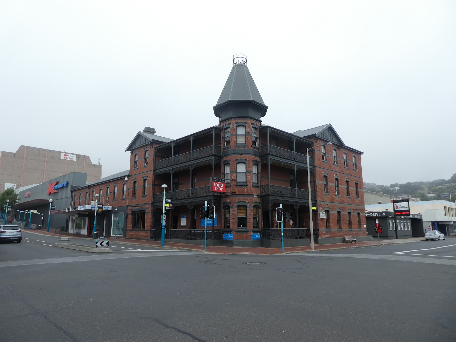
The Club Hotel on the corner of Mount and Wilmott Streets is one of the more impressive buildings in the CBD.

The views down most of the city streets in an easterly direction end with a port loading crane as a backdrop, such as here in Cattley Street.

A street covering protects shoppers crossing Wilson Street, one of the busiest of the CBD.

 St George's Anglican Church, on the corner of Mount and Cattley Streets, was the only church we came acorss in our wander around central Burnie, a CBD which unlike many others in Tasmanian towns boasts very few buildings of historical significance.
We did come across one or two which told of earlier times,

particularly at the eastern end of Cattley Street near the port, where the fog had almost obliterated the large dockside crane.

In fact, not unsurprisingly, the majority of buildings of any antiquity were clustered near the docks, including the now quite famous Baltimore Restaurant, also on Cattely Street where it meets Marine Terrace.

Mind you, this is not a place which boasts a dining view to die for.

And let's finish the 'Burnie old building' bit with one of The Baltimore's near neighbours on Marine Terrace. If this had not begun life as a bank we would eat our collective hats!

One thing we did note about the Burnie CBD was that, although the day was grey, the flowers in the street planters,

and on some of the street trees (such as this one looking along Marine Terrace towards The Baltimore) did provide a real splash of welcome colour,

as did the many light pole posters promoting the various crafts and other attractions of the 'City of Makers'.

No stroll around Bernie would be complete without a visit to the beach, and yet again I'll resort to Google Earth to give some perspective. Here you can see the port facilities including the wood chip pile, the triangle of the CBD and the Burnie beach at the top of the photo.

There we no cruise ships in today, but we were soon to learn that this Toll cargo vessel, which plies between Burnie and Melbourne, was a real regular.

A large block of modern apartments was the feature building on the sea front road

where it curved past the docks and took us on towards the beach, with the homes on the hills still shrouded in mist.

The view along North Terrace, the beachfront road, was not enhanced by the railway line which ran its length, but I guess that is one of the prices to be paid in a port city,

A well marked crossing gave us access to the Burnie Surf Lifesaving clubhouse,

an impressive building which combines the surf club

and an up market fish restaurant.

And being the weekend, and despite the less than inviting weather, the club Nippers were hard at it, training their little socks off.

Looking east back to the port area,

and in the opposite direction, we could easily see that this was an impressive stretch of sand, and by all accounts, very popular with not only the locals, but with many in the surrounding farming area.

And once little bodies have emerged covered in salt and sand, a quick splash under a waterfront octopus will soon sort that.

By now the fog was beginning to lift from the hilltops, but we had finished our central town tour. A quick fuel stop and it was time to head back to our digs.

As we pulled into a waterfront service station, I could not help but notice the ute parked in front of the adjoining hair salon, Mad Hakers.

Now for a close up........that's brutal honesty for you!
Burnie does make the claim that very good seafood is on offer here. I suspect that means in the various restaurants, but we did find a wholesale market outlet on the way back to Somerset. A large sign out the front screamed scallops, local Tassie scallops, at a price I could not believe.

But it was true. So with a few prawns to complete a seafood feast, it was into the galley with Chef Pierre on our return.

A plate of perfectly crumbed fresh seafood (a modest chef's assessment!), a bottle of fine Frogmore Creek fume blanc and a 'selfie'. Our day was complete.
I have to confess at this stage that we did not do Burnie full justice. Apart from the somewhat unpleasant weather, we were a bit jaded in the 'let's have a look at something new' department. We both recognised that a return trip to this 'City of Makers' should be included on the itinerary of our return visit to the Apple Isle (The Navigator is already making plans!).
The Cruiser service did not present us with any unpleasant surprises, and with the larder again well restocked and the tug in fine fettle, we were off next to another overnight stay on our Tassie pub crawl list.....The Rocky Cape Tavern.


