Monday, 5 November 2018

WEST FROM ROCKY CAPE - SMITHTON - PART 1 (OUR NEW HOME AT THE RIVER BREEZE PARK) (31 JANUARY - 4 FEBRUARY 2018)

Just as the locals are somewhat derisive of New Norfolk, oft referring to it as New 'Norfik', so it is with Smithton, a town which many pronounce as 'Miffton'.....ideally snorted through the nose.

Why? I have no idea, and interestingly, an old Cyprus UN colleague of mine who actually grew up there could not enlighten us. Very odd, and universal, but having now been there I can assure you all the population looked and acted completely normally!

We had not initially planned to stay here, but when poring over our charts of the north-west earlier, it became obvious that if we wanted to visit Arthur River on the island's west coast (and it had been recommended to us that we should), and stand on the most north-westerly tip at Cape Grim, Smithton provided an ideal base. 


Yet again, this was not to be a long day.....another sub 50 kilometres along the excellent Bass Highway, and for the time being we ignored the Stanley Turn-off and kept going.


Throughout this short trip we were presented with constant reminders that we were in cattle country, both beef and dairy. Herds were grazing in large numbers on either of the road, some luxuriating in lush green pastures,


whilst others took their ease in browner paddocks.


We reached Smithton in no time, welcomed by this rather natty district sign which was also universal throughout this part of the island. 'Circular Head' is the official name for that unmistakable feature at Stanley, the volcanic plug universally known as 'The Nut'.


The drizzle dampened highway took us past the large Devondale Milk factory on the approach to the town, one of several processing and industrial plants which play an important role in the area's economy.


As my old friend Google Earth shows, Smithton is built on and around Duck River, a waterway which ends in a large and muddy tidal flatland as it empties into the sea. 


The River Breeze Caravan Park which was to be our new home for a few days, is aptly named. It lies right on the banks of Duck River (indicated by the red arrow).


At the Devondale factory we had two options. One was to turn right there and follow Britton Road on its northerly route into and through the CBD, or to continue on to the point where the Bass Highway intersected with Nelson Street. We knew that we had to reach the bridge over the river and continue west along Montagu Road,


so we chose the more direct route and made our way along the length of Nelson Street 


past our first sighting of another of the large processing plants here, the McCain factory, 


and on to the bridge which would take us across Duck River.


Beyond that the road now curved left past the Bridge Hotel Motel 


and headlong into something we could not have predicted.....roadworks! Damn.


Fortunately this stretch of 'ground under repair', as they say in the golfing world, was not too long and had been graded well enough so that we were not banging and bashing through potholes.


Nevertheless the sight of the park gate was welcome.


We eased off the road and through the clearly defined main gates


and made our way into the park past the barren looking row of unoccupied sites at the front. This was a less than inspiring sight, 


but we pressed on regardless down the entrance road 


towards the large shed at the end of it


where we had correctly assumed we would find the park office (right at the far end). With the sign over one of the roller doors announcing that these were the premises of a trailer service centre, we were beginning to wonder what we had let ourselves in for.


As it turned out we had no need for concern. The lass in the office could not have been more welcoming, and soon confirmed that the river side site we had booked was awaiting our arrival. She even went as far as apologising for the rather barren looking surrounds, and explained what we already knew.....this was an exceptionally dry summer.


To get to our allotted spot, we had to then drive down past the end of the large park shed and the couple of cabins on the opposite side of the roadway,


and thence past this row of vans, mobile homes and work trucks at the bottom end of the grounds.


The riverside sites were all below the office building and rear deck area, and although the sandy ground was dry and pretty bare, with our trusty C-Gear deployed underfoot and the awning out and secured overhead, we were more than set.


We were told that the grey building just above our site


was the ablution block for those in this section of the park. 'Hmmm', was our first reaction, but here we had the classic situation of 'books and covers'.


The head,


central laundry,


and shower cubicle, enclosed in another room, were all brand new and kept immaculately clean. 


And with very few of us lined up here along the river at any one time, there was no 'rush hour'. It was almost like having our own private bathroom.


A second amenities block serviced those who had chosen sites at the front of the park, and whilst there was no camp kitchen as such,


a large BBQ and communal seating was all on hand on the decking overlooking the river


to which we had easy access up this flight of stairs immediately in front our our site.


And, needless to say, I did take advantage of these facilities on more than one occasion, this time as the water in Duck River was flooding in below us.


As you may have gathered from the Google Earth shot, at the point where our park was situated, Duck River was completely tidal, and the ebbs and flows were significant. Its mood would change completely twice a day, from the broad placid expanse of blue water of high tide,


to a mere trickle between the mudflats at the bottom of the ebb.


The volume of water which came and went was amazing, given how far upstream we were.


I would invite you to note the pile of exposed rocks on the far bank seen here (obviously) at low tide.


When the tide had fully flooded in,


this tip of the highest rock of the pile was all that could be seen.


The river is well named, as we learnt on our first day. This is where we expected to see these adults and their youngsters, safe and sound out on the water.


but as we settled in for our first afternoon happy hour, and the waters of Duck River ebbed away, this little feathered family decided it was high time to check out the newcomers,
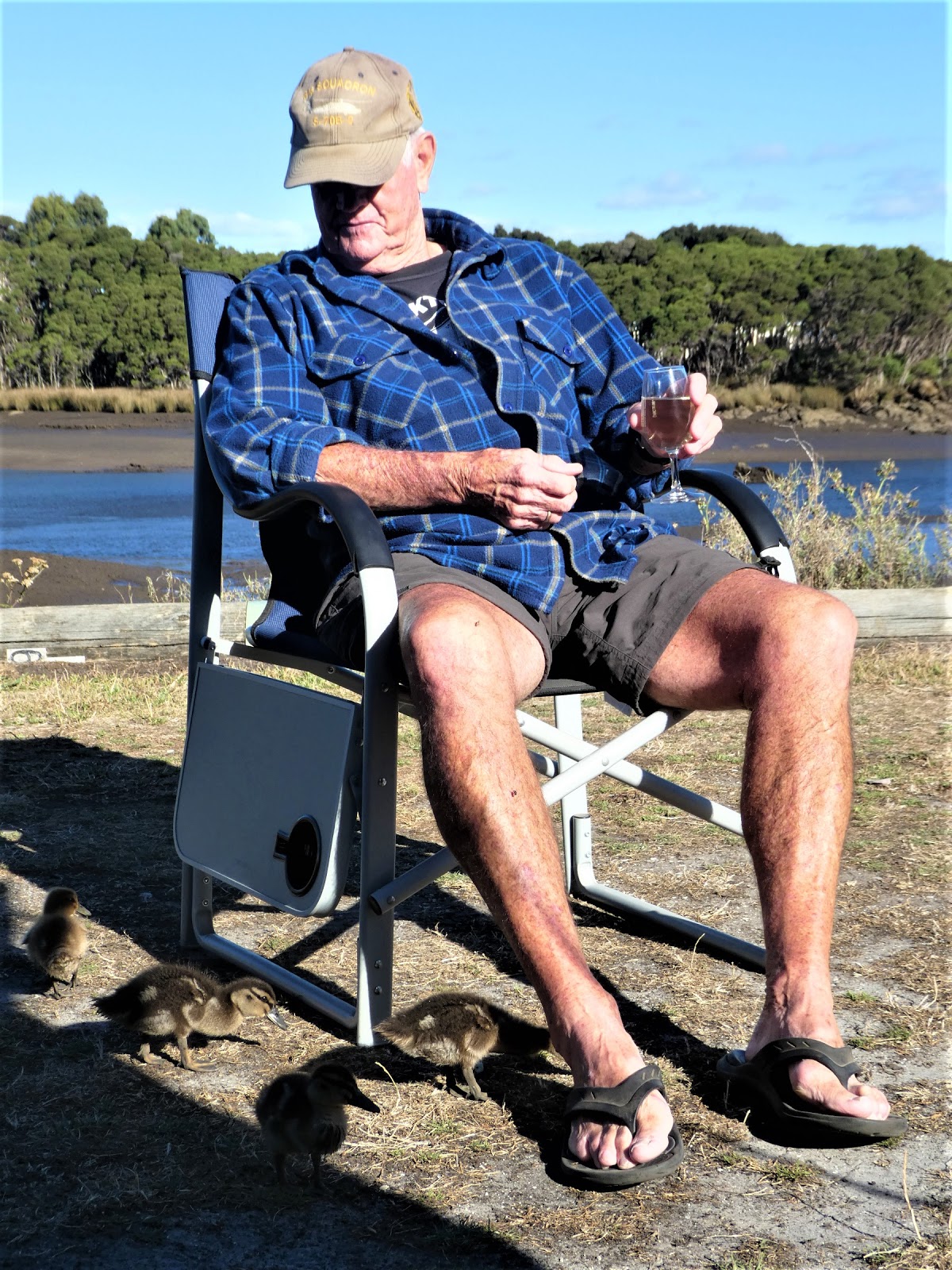


at close quarters and in detail! They were quite fearless, and obviously used to the comings and goings of the likes of folk such us.


Now that I could understand without too much difficulty, but when they all settled down within clear sight of what I would have expected them to view as a real threat, I realised these were decidedly different ducks! And, as we expected, Max was utterly indifferent to their presence. As I have often commented, the Ship's Cat would starve in the wild!


Ducks were not our only feathered friends. 'Turbo chooks' would meander past foraging on a regular basis,


whilst across the river, this gaggle of gregarious geese gathered daily on the bare banks


before taking to the water on the incoming tide and crossing the river to annoy us all on this side with their noisy and demanding honking.


Apart from being home to the camp BBQ, the top deck was also the gathering place for any who wished to share a yarn or two with Greg, the park owner, and a few of the regulars who were happy to chew the fat there on a daily basis.

It was here we learnt that Greg was an earthmoving contractor and general mechanic and had bought the park site as a bare patch of river side land a few years ago. He was the first to admit that it remained a work in progress, but we were quick to assure him that we were entirely happy with our site and the facilities on offer. 

There is nothing quite like being 'on the water' even if, for parts of the day, our vista was one of tidal mud flats. Even they have an appeal of their own, and to our abiding relief were not home to myriads of midges, which would have been inevitable elsewhere in warmer climes. 

As you may have gathered by now, were more than happy to have migrated to 'Miffton'!

Saturday, 3 November 2018

ROCKING AT THE CAPE - THE ROCKY CAPE TAVERN (30 JANUARY 2018)

Today was to be the first leg of our trip west along the north coast. Our eventual target destination was Stanley, but we had a few spots on our list before we reached that historic town, including another Tassie pub. The Rocky Cape Tavern is well known for its camping ground, and it is only just over 40 kms from Somerset. This was to be a very short day on the road.


The fog and gloom had finally cleared. Clumps of cumulus cloud hovered overhead as we hauled out of Somerset, west along the Bass Highway, a surprisingly busy road, particularly with all the log jinkers hauling timber to the Burnie woodchipping factory from the forests of the north-west.


I have to say, quite selfishly, that it was great to be travelling along a coast again, particularly when sights like this came into view. Table Cape is a very well know north coast landmark just west of Wynyard.


The north coast of Tasmania is home to a plethora of small and, in many cases, very attractive beach locations. We were to visit Boat Harbour and Sisters Beach later as we roamed around this part of the Apple Isle.


Although not nearly as big as Burnie, Wynyard is a significant north coast town, but because it lies just off the main highway, today we by-passed it. 


Is there anywhere on this island which does not provide delightful country scenery? Even with the pastures dessicated by the unusually dry summer, the farming lands of the north-west were a picture.


In a few spots the Bass Highway runs quite close to the coast when sights like this are the result.


This entire area is known for its excellent soils, and paddocks of irrigated pastures are not uncommon. 


But as we had come to expect, every Tasmanian highway continues to throw up differing vistas 


with every passing kilometre.


Some are more unusual than others. This initially puzzling piece of roadside art made sense once we had the chance to take a closer look. Trees, cattle, wind turbines and the sea represent the forestry, dairy, and fishing industries which predominate throughout this area, together with a large wind farm out near Cape Grim, the most north-westerly point of Tasmania.


And we must not forget the potatoes, grown throughout the north-west in almost unbelievable quantities. The 'local' towns of Ulverstone and Smithton both house large potato processing factories (as we shall see later in Smithton). The regional 'Pink Eye' variety is especially favoured, and after having first sampled these when staying with our good friends at Margate, we could understand why.


One enterprising farming family had obviously had some spare time on their hands. We wondered if someone should remind them that the Festive Season was well and truly over!


Not too far beyond 'Santa on a Bike', a bend in the road and an elevated section of the highway gave us our first view of this famous Tasmanian landmark. 'The Nut' rises high above the historic coastal town of Stanley. 


In what is a sadly hazy shot, you can just make out the low lying hull of a large bulk carrier. This was also our first look at Port Latta, the facility at which the iron ore sludge from the Savage River mine is reconstituted and loaded for export to China.


With another few bends negotiated and a few more kilometres covered, we found ourselves in the driveway of the Rocky Cape Tavern, one of the last of the Tassie pubs on our 'crawl' list.


This had, for many moons, been a free camp, but things had changed, as the alterations and obliterations on the camp gate sign made quite clear. For one night only we had no need of the showers (it's amazing what one can do with a flannel and a bowl of hot water), had our own toilet on board and did not need power or water. The $5 option was just right for us.


Duly paid and stamped, we were invited to chose whatever patch we liked. This spot in the front corner, where the fence gave us some protection from both wind and highway noise, suited us. There was a van already in situ next to us, but our widely extended awning guy ropes ensured that no late arriving idiot could try to squeeze in between us.


This may sound a touch paranoid, but you would not believe just how intrusive some can be, particuarly overseas 'backpacker' types who roam the countryside in 'whizz-bangs' or clapped out 4W drives. A good travelling companion of ours once came back to his site in a free camp to find a campervan actually parked on his awning mat. Needless to say, the ensuing discussion was short and sharp.


Even although no longer free, the Rocky Cape Tavern camp ground was excellent, and despite being quiet on our arrival, soon began to fill along this unpowered side of the grounds.


The powered sites were mostly to be found on this far less appealing gravel area, 


but for those wanting grass, a few were available at the back end of the park


 where a stand of large trees followed the line of a creek which formed the back boundary.


The ablution block stood just behind the small, grassed  playground area but given our circumstances, I cannot comment on the standard of the facilities.


A few cabins completed the scene as far as the park was concerned, but of course we still had the tavern to visit.


I have to say that this long, low building was not quite what I had expected, why I don't know. I suspect the word 'tavern' conjured up visions of a much older 'bush' hostelry.


This watering hole sits right  on the Bass Highway which, as I mentioned previously, does carry a substantial amount of traffic. Prominent amongst this are trucks from the Toll company, many of which were engaged in moving potato products from the Smithton factory to the port at Burnie.  


The scene on the other side of the highway was a reminder of the fact that we were very much in dairy country. 


We had decided before arriving that we would take a night off from the galley here and treat ourselves to an evening meal in the pub.


Here we found a modern light and spacious front bar where the obliging staff were more than happy to dispense a pre dinner drink or two. We were equally happy to receive them.


The walls of the passage which led us to the dining room were decorated with large and informative boards, which provided a very good insight into the flourishing timber industry which has existed in this area for decades.


The decor and furnishing of the dining room itself was consistent with the rest of the tavern.....light, modern and functional.


I cannot remember now for the life of me what we had for dinner, but I do recall we were more than happy with both the quality and quantity of the fare on our plates. I also recall, however, that we did spoil ourselves when it same to the wine list. We washed our meals down with a real treat...a Josef Chromy pinot, one of the best drops from one of Tassie's premier wine makers. The Rocky Cape Tavern received the mark of approval from the Mobile Marshies as having upheld the standards of the Tassie pub crawl group. 

With this one ticked off we had but two more to do, at Mole Creek and Weldborough, but these were yet some time away. Tomorrow we were off to Smithton.