I must begin this offering with a disclaimer. As you will see, the blog programme has decided to have one of its occasional, and totally frustratingly unpredictable, conniptions which has prevented me from being able to centre the text around the photos. Apologies for the tatty visual result.
To business. In all of our travels to date, one thing which constantly amazes us is the degree to which the countryside can change in what seems no time at all. Our journey from Kurrimine Beach to Mount Surprise was no exception. At 0830 hours we were travelling through mountainous coastal tropical rain forest country, through cane fields, banana and mango plantations, all green, lush and bustling with the activity of the cane harvest.
To business. In all of our travels to date, one thing which constantly amazes us is the degree to which the countryside can change in what seems no time at all. Our journey from Kurrimine Beach to Mount Surprise was no exception. At 0830 hours we were travelling through mountainous coastal tropical rain forest country, through cane fields, banana and mango plantations, all green, lush and bustling with the activity of the cane harvest.
In a mere four hours here we were driving into the tiny outback township of Mount Surprise where green gave way to brown and the flat, open land was dry, dusty and shimmering with mid-day heat.

After having spent almost three months in the wet tropics our return to the outback was something of a culture shock, exacerbated by the fact that the land is in the grip of drought. We were returning to country we had seen last year when it was at its best.....what a difference now.
 What could we expect at the Bedrock Caravan Park? The green and welcoming entrance was encouraging to say the least,
 as was the view along the driveway to the office. Plenty of trees and the odd smattering of green lawn was a very promising view.
We had accepted the fact that for the next few weeks of our trip west and south, dusty park sites would be the norm. What we needed now was shade. And at Bedrock this was certainly on offer. Out came our special outdoor matting, the stuff which prevents dirt coming through it (and it really does work), and we were all set for a look around.
This park has an interesting history, one which reminded us to a degree of the development of 'Evening Star', the park on a cattle station just out of Charleville where we spent two great nights last year.
The owners of 'Bedrock' bought the area in the mid 1990's when it was nothing more than barren, deserted grazing land. At that stage 'Jo' was a local diesel engineer and his wife, 'Joe', a school administrator. As they sat in the house they built on the property they noted the number of caravans which travelled through Mount Surprise, but did not stop. The idea of Bedrock was born, and after ten years of very hard work, which included not only the development of the sites and infrastructure but the planting of over 5,000 trees, the caravan park as it is today emerged.
 It is a cracker of a park for this part of the world, and, as we discovered, hosts all sorts of entertainment and extra-curricular activity during 'the season' (which had just ended as we arrived) in the huge rec room at one end of the park
 This fine facility abuts an open area in which there is to be found the park pool
 next to which is the large open camp fire area
 and, of course (what park doesn't have one of these), the huge, wood fired pizza oven.
 And as if this were not enough, the office complex hosts a fully equipped commercial kitchen and restaurant from which breakfast, lunch and dinner may be bought and eaten in the nearby dining area.
  There is even a put-put course for those who wish to spend an hour or two of frustration (or off load the kids for a while).
In addition to all that the park provides on site, staff also run tours to the Undara lava tubes (both full and half day) and to a nearby cattle station. For the three months of June, July and August, the owners employ a casual staff of over twenty to cater for the many who apparently come here for a number of weeks.
And, would you believe, we know just such a person. Lynne, who worked for a number of years as secretary to my close mate Hens B in his Bankstown aircraft engineering business, has spent a number of recent years working at Bedrock during the winter months. We just caught her....the day of our arrival was her last for 2013. Mind you, given that I'd not seen her for over thirty years it was just as well she was wearing her name tag. But we did catch up and had a good chat about times gone by. And she agrees with us Mr B....it's time to retire!
We had booked a half day tubes tour for the following day, so decided that now would be the time to take in the sights of the Mount Surprise township, of which there is not much. But as I have said before, the more one looks the more one finds.

We began our tour at the eastern end of the town, through which the Savannah Way forms the main street, and soon discovered that, like so any of these small towns, one business premises will provide a number of services.
 Here, the gem shop also caters for those wishing to post letters or to sip on a cuppa,
 whilst for those who choose to stay in the small caravan park in the centre of the town can watch a snake show as they have their tires repaired. Now that's an offer which doesn't come along every day!
 The old 'servo' is now the general store
  but the pub is still the pub
 where obviously the proprietor has a sense of humour!
 As does the local copper. The police office and residence was relatively average, but not the signage.
  I suspect it would only be the very bold or very stupid who would ignore this and approach the front door of the police residence rather than the office. We later ran into the local incumbent as he was mounting a radar site past the school crossing. He was a terrific young lad whose brother-in-law is a sign writer, hence the very professional finish. It appears he has now taken orders for similar hardware from many of his country colleagues in small one-man stations. I didn't get around to asking what the official reaction had been..hopefully supportive of the initiative.
 Mount Surprise sits astride the rail link between Cairns and Forsayth. The 'Savanahlander' passes through once a week for 42 weeks of the year. This tourist train takes passengers on a rail car journey from the coast to the outback over four days and nights visiting places such as Karanda, Mareeba, across the Atherton Tableland and on to attractions such as Cobbold Gorge and the Undara Lava tubes. As the size of the station suggests, this train consists of only two carriages.
One of the things which has struck us in this part of the world has been the strong association with WW2 activities. Mount Surprise was no exception. It was the location of a particularly secret radar station, established obviously to monitor any approach by the potentially invading Japanese.

From what we could gather reading the relevant plaque, those tasked with operating the radar station found the social life and general amenity at Mount Surprise somewhat lacking, although much effort was made to provide some for of sporting and other activities.
But enough of the town....let's go on our tour of the Undara Lava tubes, or at least the portion of them which can be taken in in the half day tour. This was to be an extraordinary day.
The Undara volcanic eruption was but one of many in this region, where volcanic cones and hills can be seen in all directions. Our first stop after leaving the caravan park was at the base of the Kalkani crater shown here from the air in a shot I filched from the Internet.

The entrance road took us to the base of a walking trail where we assembled for the hike to the rim and as you can see, the scenery at ground level is not nearly as spectacular as from the air.

Off we went, dutifully trailing behind Mark, our guide for the tour (or at least most of us did....there were a few stragglers!)
 until we reached a point on the trail where we could look across the crater bowl to the western rim. You may think that it appears higher than the eastern rim on which we were standing..you are right. Incredibly, as the ash and rock was ejected during the eruptions at this site, the prevailing easterly winds deposited more material on the western side of the crater than the east. And I have to say on the day we visited, I could well understand this phenomenon. The easterly was howling at about 30 knots up on the rim.
Apparently the crater bowl is often filled with water, but in the current drought conditions a crater lake at Kalkani is but a memory.
Not all the volcanic activity in this area produced the cone shaped craters which are most commonly associated with these eruptions.

As this trackside sign explained, some shoot upwards and others ooze their lava. Undara itself was an 'oozer' as I shall explain later.

The track on the northern and western edges of the rim changed markedly from red earth to the dirty dark brown dust, pumice and scoria which had been ejected by Kalkani,

which, in some stretches, demanded more than passing attention to foot placement.
But enough of the town....let's go on our tour of the Undara Lava tubes, or at least the portion of them which can be taken in in the half day tour. This was to be an extraordinary day.

The Undara volcanic eruption was but one of many in this region, where volcanic cones and hills can be seen in all directions. Our first stop after leaving the caravan park was at the base of the Kalkani crater shown here from the air in a shot I filched from the Internet.

The entrance road took us to the base of a walking trail where we assembled for the hike to the rim and as you can see, the scenery at ground level is not nearly as spectacular as from the air.

Off we went, dutifully trailing behind Mark, our guide for the tour (or at least most of us did....there were a few stragglers!)

Apparently the crater bowl is often filled with water, but in the current drought conditions a crater lake at Kalkani is but a memory.
Not all the volcanic activity in this area produced the cone shaped craters which are most commonly associated with these eruptions.

As this trackside sign explained, some shoot upwards and others ooze their lava. Undara itself was an 'oozer' as I shall explain later.

The track on the northern and western edges of the rim changed markedly from red earth to the dirty dark brown dust, pumice and scoria which had been ejected by Kalkani,

which, in some stretches, demanded more than passing attention to foot placement.

But from here we were treated to views of the plains below and the track over which we had driven to reach the bottom of the crater.
 It was on this section of the rim that another surprise was in store. As the redoubtable Mark explained, this vegetation is known as 'evergreen vine thicket'. So what? Well, this is one of the few plants in this area which is not fire resistant. It has survived in this tiny area of the rim purely because of the fact that the rocky nature of the hill below does not allow a fire to burn up the slopes at this point. This is a remnant of the ancient vegetation of the volcanic plains of Undara.
Further on we came to the point where we could view the plains to the south and east, and here, in the distance, stands the shield hump of Undara itself.

Here you can see four cone craters and, off to the right of the shot, the larger residual humped shape of the Undara eruption. Whilst the limitations of my photography do not bring it to the fore, I have to say that standing up here looking at the remains of these ancient volcanoes which rise out of the plains on all points of the compass, was strangely eerie. I had no trouble envisaging the smoking, prehistoric landscape so often depicted in paintings or the era.
And so it was we trudged our way back down the track to the car park for our 'cuppa and cake' which seems strangely mandatory for these types of tours (I'd rather spend the time 'touring') before we began the main event....the lava tubes.
What extraordinary things these are. Our tour took in but two of the several of these natural phenomena which, in length and form, are the largest of their kind in the world. So how did they all come about?
When Undara erupted some 190,000 years ago, rather than hurling masses of volcanic rock and ash skywards, it oozed tonnes and tonnes of viscous lava which flowed down the hillside and into natural depressions in the earth. As the lava flowed slowly along these defiles, the upper sides cooled to form a crust. The still hot lava within these lengthening chambers of rock flowed on inexorably until the eruption ceased. The end result was a system of rock tubes, one of which is over 160 kms long. Some of the resulting caverns contain water sources, but the two we were to visit are both dry.
 The existence of the tubes is a fairly recent discovery. It is not until a section of the roof caves in that their presence becomes obvious. To give you an idea, this is a shot of the landscape directly over the first tube we later entered. Apart from some volcanic rubble, there is nothing to indicate the cavern below.
 Our track into the first tube took us past one of the curious trees we had noticed whilst driving into Mount Surprise. Mark was quick to respond to my enquiry with the information it is a Kurrajong tree, the Queensland 'bottle tree', obviously nicknamed for the shape of its water holding trunk. We were a little disappointed to discover that in two weeks time or so the entire tree will be a mass of bright blossom (it looked dead at the moment!)
  And whilst on the subject of local flora and fauna I have to include a shot of this brush turkey nest we passed, not so much for itself, but as the catalyst for a very funny comment from one of our group. As we stopped at the mound Mark explained how several females will share the mound. After they have laid their eggs, their respective male partners tend the clutches, testing the interior temperature with their tongues. If the nest is too warm, they scratch off some of the litter...if too cool, the opposite. Mark went to explain how he has watched two turkeys do just that in successive maintenance efforts on the same part of the mound....one scratched off, one scratched back on. And then from the back of our pack...."Just like blokes over a BBQ" Touche madam!
 But enough of these asides, on to the tubes where the first task is to descend from the surface of the plain down towards the tube entrances. Notwithstanding the sturdy ropes provided, these rocky declines demanded the full attention of all traversing them.
 At the bottom another track awaited, at the end of which we were given a further discourse on the formation of the tubes
 before we finally came to our first entrance.
 And in we went, once again clinging grimly, in some cases, to the ropes provided.
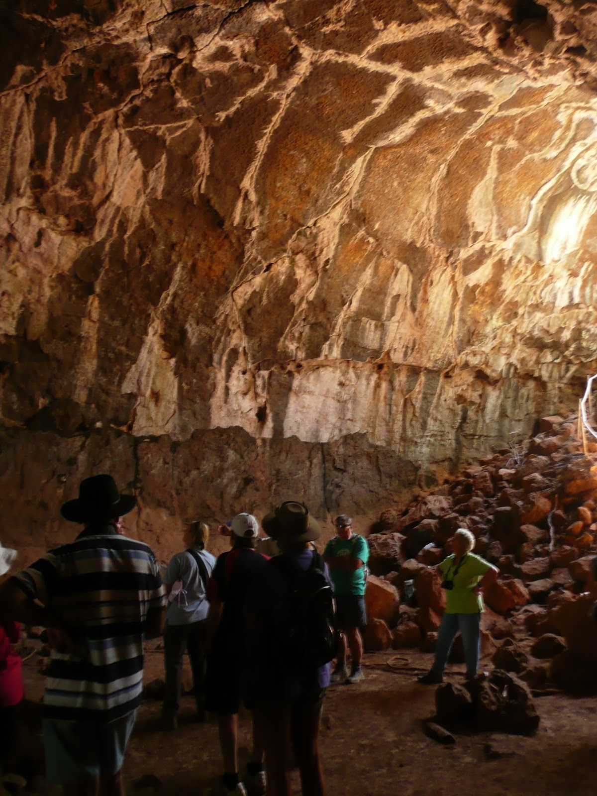
 The floor of our first tube was covered with powdered silt, as is the case apparently with many of the tubes, but what a sight it presented nevertheless,
particularly when looking up at the magnificent colours of roof of the tube. This amazing display is the result of water leaching through the porous outer rock and depositing dissolved minerals on the ceiling of the vault. Our guide did name the origins of the various colours, but apart from the white of calcium carbonate my memory has deserted me.

I do recall mention of potassium and magnesium, but beyond that it is all guesswork! I was too busy taking it all in to make notes!
 I found it quite difficult to provide a photographic perspective of the size of these chambers, but hopefully this shot does help. The entrance to the tube can just be seen at the far right of the shot....the rest is self explanatory. They are impressive, and this is one of the shortest.
 The second of our two tubes provided a different experience altogether. This much larger tube is home to the lava tube micobats, but, of course, to find them we had to get in. This shot of the upper edge of the entrance give some idea of the thickness of the roof material.
 Once again we clambered down the large rocks which tumbled from the entrance archway to the floor of the tube and the gloom beyond.
This was a much longer and darker tube which is not really surprising given it is the bat cave. And its roof was much higher than the first we visited.

 Another feature of this particular tube were a number of off-shoot lava flows which had branched from the main tunnel. These have all silted up by but their original departure points can still be seen, again with magnificent colours deposited in the roof arch. As for the dots in the shot, these are particles of tube dust which unfortunately are an unavoidable feature of photography in this particular tube.
But where are the bats...we have paid good money to see bats! On along the tube wall we edged (the floor in this one was very rocky and uneven, hence the Indian file along the wall)

as our trusty guide scanned the ceiling with his torch. Come on Mark, where are they? "In the torch beam, believe me.....remember they are microbats!" And sure enough, as we all got closer, a cluster of the tiny creatures could be seen huddled together high on the wall.

I have to confess to something of an anticlimax as we gazed at these tiny creatures. To give some perspective, the black speck in the narrow seam of light coloured material in the mid-upper left of the shot is one bat. But believe me, these little chaps punch well above their weight when it comes to toiletry. Those in the know do not stand directly below them!
Was the $80 per head tour fee worth it? Well, the short answer is that there is no choice. Entry to the tubes and their surrounds is prohibited to all but those with accredited guides. I initially through this to be a good way to turn a buck, but the fact of the matter is that some of the area is quite dangerous. Not only does the are abound with concealed shafts and holes, more importantly, the atmosphere in some of the tubes is highly toxic with large percentages of carbon dioxide present.
But to answer the question more specifically, yes it was worth it. These tubes are a unique part of the Australian outback, and, as I mentioned previously, significant on the world geological stage. We had both long wanted to see them and, whilst those nearer Undara itself in which tropical plants thrive remain on the bucket list for our next sortie to these parts, we returned to Bedrock well satisfied with the day's endeavours.
Next, further north-west on the Savannah for an overnight stop at Croydon before making our way to Normanton for a couple of days R&R around the big park pool and perhaps a beer or two at the Albion.
Both these towns featured extensively in last year's blog, so I'll not bore you with repetition, other than to note that what was this time last year a very green and leafy Croydon is currently a dust bowl. Fortunately the park owner pre-warned us when I booked our site...he did not exaggerate!

Believe it or not, this entire expanse of dust and dry grass was, this time last year, completely green lawn. Things are certainly grim in this part of the world.


No comments:
Post a Comment