To my great frustration I must begin this missive with an apology for the variation in font size part way through it. I have no idea what caused this, and, after many attempts to rectify the error (and 7 hours already spent editing photos, doing research and compiling this blog) I have given up....in disgust!
The Fitzroy is indeed a mighty river. Named after Captain Robert Fitzroy who skippered 'The Beagle' around the world in the early 1830's with Charles Darwin on board, the Fitzroy rises in the King Leopold and Muller Ranges and, with its twenty tributaries, empties a catchment of nearly 95,000 square kilometres as it flows almost 750 kilometres to the coast.
The Fitzroy is indeed a mighty river. Named after Captain Robert Fitzroy who skippered 'The Beagle' around the world in the early 1830's with Charles Darwin on board, the Fitzroy rises in the King Leopold and Muller Ranges and, with its twenty tributaries, empties a catchment of nearly 95,000 square kilometres as it flows almost 750 kilometres to the coast.

We had already seen what it does to the waters of King Sound as it empties into the sea near Derby, and that was in 'the dry' when upstream the river meanders benignly through the residual sandbanks of its bed.

In the wet everything changes. As the monsoonal rains dump on its catchment, the Fitzroy is transformed into a raging beast, as this one photo (thanks again to kimberleymedia.photoshelter) of the torrent pouring through the Sir John Gorge shows.
The statistics are staggering. In full spate the Fitzroy delivers almost 30,000 tonnes of water past any given point every second! The Fitzroy River becomes one of the largest in the entire world. Put another way, this flow would be enough to fill Sydney Harbour in 12 hours, or on a smaller scale, twelve Olympic sized swimming pools every second. I'll leave you to ponder!
The Kimberley area around Fitzroy Crossing was first explored in the late 1870's when its excellent grazing potential was realised. Cattle stations were established, but not without some incredible hardships. Take the story of the MacDonalds of Fossil Downs for example. In 1883 the family leased land near the junction of the Fitzroy and Margaret Rivers to run cattle. That all sounds pretty straight forward does it not? Not so. The MacDonalds actually lived in Cliffords Creek, New South Wales at the time and there was only one way to stock the newly acquired property.....drove the cattle overland.
So, in March 1883, Donald MacDonald and his two sons, Charles and William, set out with 700 cattle and 60 horses. Sadly Donald was thrown from his horse and died early into the trek, but the sons pressed on, and on and on. They finally arrived at Fossil Downs in June 1887 with their remaining 327 cattle and 13 horses. I need no convincing that this is believed to have been the longest cattle drove in Australian history, all 5,600 kilometres of it. What an incredible feat of endurance.
Fossil Downs became very successful and remained in the MacDonald family until very recently when it was bought by none other than Gina Rinehart (it's interesting to note how the WA mining giants are now investing in cattle properties....Twiggy Forrest and Gina Rinehart compete again!)
Not too long after this, in 1892, a Post Office telegraph station was opened in the area, followed by a Police camp and, in July 1897 a licence as issued for the shanty inn and trading post which had been established at the crossing point over the Fitzroy River.

It was time to head out and have a look at the original 'Fitzroy Crossing' where the road took me past large tracts of burnt off grassland, a precaution against raging bush fires around the town during the dry.
Some 10 kms or so out from the present township is the turn off into the original settlement site.

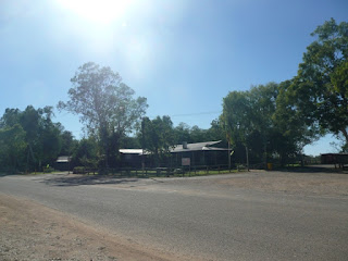
where the now dirt road took me past the old post office building which still looked to be in remarkably good nick. (I think it is now being used for worker accommodation).
The approach to the old river crossing was not too far away. The sign told me it was open.

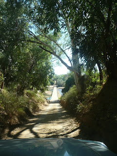
It is some approach! As I crawled down towards the river bed along this narrowest of tracks I could not believe that this was used consistently by road trains for many years. They must have just scraped through.

And there it was....the causeway of the famous Fitzroy River Crossing lay before me.

All that remained was to do it,

across and up the other side where I looked back with some satisfaction.....this is a place with a real history.

The waters of the Fitzroy were flowing under the crossing gently
and crystal clear.
On this soft Kimberley morning, as the Fitzroy meandered past the sandbanks it was hard to imagine this crossing under thirteen metres of muddy, raging torrents but that's exactly what happens in the wet.
Needless to say, the river was impassable at these times, and could be so for up to three months. This situation was finally rectified in 1974 when the new (and current) bridge was built some 10 kms to the south, and the town moved with it.
I was amazed to learn that although Fitzroy Crossing has been officially on the map since 1903, the old township was never formally recognised and the current town was not officially gazetted until 1975.
In the days or yore, when one just had to hang around waiting for the river levels to drop, an opportunity presented itself to an enterprising gent of the time, one Joseph Blythe. In 1897 he was granted the licence for his river bank 'shanty inn and trade store' from which he dispensed a refreshing brew (and sold more practical items) to prospectors (The Halls Creek gold rush was on), bullock team drivers, drovers and locals alike. The original buildings are long gone, but the site still remains that of the oldest Kimberley Pub,
now in its present form as the Crossing Inn.
This is a pub of parts.
Next to the reception doorway
is the entrance to the pub's Indigenous Art Gallery, where the local ban prevented me from bringing its contents to you pictorially.
But as you can see the outside walls are quite a different story, and what a great story this is. Let me quote directly from the Crossing Inn website.
"The Crossing Inn supports many of the initiatives aimed at improving the
well-being of
the community. For example, inspired by the success of the High School
winning the 2000 Olympic Art Competition, the Crossing Inn sponsored and
challenged the local youth to do paintings for the outside walls of the
100 year old hotel. The results are amazing - outstanding in both
artistic merit
and their local content. So the wall of this popular and historic hotel
are now a tourist attraction in their own right, and are a wonderful
museum of
local heritage, culture and art."
From the driveway leading to the Garden Bar,
the close proximity of the river is obvious.....and remember, this is 'the dry'.
This pub has been rebuilt many times as flood waters have wreaked havoc on the structure. In their own quirky way, the owners measure the height of the inundations by the number of bricks reached up the wall. The flood of 1933, for example, was a 'nine brick' torrent.
You may wonder why I'll not be posting any interior photos nor regaling you with tales of the folk we met here at the bar. There is a very good reason for that.
In stark contrast to the remainder of this establishment, the front bar is less than inviting. It was closed at the time of my visit but I had it on very good advice that this is not the place for a quiet tipple. This is the local indigenous watering hole (exclusively) and can apparently become somewhat challenging at the drop of a hat. I was the subject of a 'spousal ban', something to which I submitted with resigned grace.
During a formal tour of this area we were told that it was not so long ago that the approach roads to, and the surrounds of, the Crossing Inn were awash with cans. The locals would just toss them aside once the contents had been consumed. There are reports that the extent of this shimmering mass of metal could be seen from space.
Finally someone had the bright idea that this could be a useful resource. Much of the improvements to the local school and other community infrastructure have been funded by the 'Can Fund', with the obvious beneficial results to the environment.
And if there were any doubt the association between this pub and the locals, the many warning signs posted along the roadway to it from the township soon dispel that thought. But here again
commendable local youth involvement is at the forefront of this initiative.

All these signs have been created by kids from the Fitzroy Crossing school

with messages which are clear and simple. Hats off to whomever thought of this project. The younger generation being educated through involvement....great stuff.....there is nothing as powerful as ownership.
And it is on that hopefully positive note that I end our Fitzroy Crossing adventure......with one exception....the stunning Geike Gorge is still to come, a must for inclusion in any visit to 'The Crossing'.
And if there were any doubt the association between this pub and the locals, the many warning signs posted along the roadway to it from the township soon dispel that thought. But here again
commendable local youth involvement is at the forefront of this initiative.

All these signs have been created by kids from the Fitzroy Crossing school

with messages which are clear and simple. Hats off to whomever thought of this project. The younger generation being educated through involvement....great stuff.....there is nothing as powerful as ownership.
And it is on that hopefully positive note that I end our Fitzroy Crossing adventure......with one exception....the stunning Geike Gorge is still to come, a must for inclusion in any visit to 'The Crossing'.


No comments:
Post a Comment