Wednesday 26 September 2012

CALOUNDRA - GRAFTON (15 - 16 SEPTEMBER)

Our departure from Golden Beach was something to which I had not been entirely looking forward.  Despite the assurances from the park manager that we could easily slide out past the lamp post which was a feature of the front corner of our site, I was somewhat sceptical of his confidence.  He knows his job!  Like a liner leaving the dock we sailed majestically (and very slowly) onto the park roadway, of the park and thence into the Caloundra traffic as we headed off south yet again.
 
We had decided to make Murwillumbah, a small town some 15 kms off the Pacific Highway in the Tweed Valley, our afternoon destination for no real reasons other than we had never been there before and it was in the target travelling distance range (and advertised drive-through sites...a boon when merely overnighting).
 
The view to the south along the approach road is dominated by Mount Warning.  Like the Glasshouse Mountains, this is another volcanic plug of rock so hard that it has survived the weathering process which has eroded all around it.  Even in the distant haze, it is a very impressive sight.


The Mount Warning volcano is believed to have last erupted some 23 million years ago.  Since then the crater has collapsed to form a large caldera which surrounds the mountain.  A number of the norther NSW rivers, including the Tweed, have their headwaters around this caldera.  The peak was named by Cook during his voyage up the east coast.  Shortly after sighting the mountain, he was forced to navigate rapidly to the east to avoid the shallow coastal reefs which lie just off what is now called Final Head (many believe that Cook actually named this Point Danger which makes absolute sense to me).  From Cook's perspective, a sighting of Mount Warning provided mariners with ample opportunity to change course at an appropriate time, hence the name.


But enough of the geography and history lesson. Murwillumbah awaits, and what a treat lay in store for the Mobile Marshies at the Greenhills Caravan Park.  A drive-through site indeed.....it was a veritable paddock, shaded by huge trees and overlooking cane fields and woodland.  Even this shot does not do real justice to the area. 


In fact the entire park was open, well grassed and studded with, and surrounded by, large shade trees. A real find, and with what we later saw (briefly) of the delightful Tweed Valley, this is a park  we shall undoubtedly revisit.


Paradoxically, even though this site was the biggest we have ever seen, with no need whatsoever to unhitch, we had decided as we drove into Murwillumbah that the town looked so interesting we just had to explore....given the park was 3 kms beyond the town centre, unhitch we did.
 
It was well worth the effort.  What an interesting town.  The legendary Nimbin of the flower power era of the 70's and early 80's is a mere 40kms or so away, and I have to say that there are significant remaining examples of those times to be seen in Murwillumbah.  Apart from the many locals whose attire and hairstyles transported your correspondent immediately back to his undercover drug squad days, many of the commercial premises in the main shopping precinct offered what could only be described as 'alternative' services. 

Main street Murwillumbah could best be described as quaint.  In fact, sections of 'old Murwillumbah' reminded me of Scotland for reasons I cannot fully explain...gut feeling I guess.


Many local houses cling to the densely forested hills which surround parts of the CBD


in which we found a number of curios, including this backstreet overpass, something I've not seen for many years,


and this gem of the 50's and 60's, the 'Austral Cafe', which was unfortunately closed for a private function.  And there we were just hanging out for a strawberry spider and a chocolate double malted! 


And now for the Murwillumbah 'quirky'.  But three doors distant from the Austral we came across a pub on which this notice was posted.  Now we have no idea what the standards are beyond the front door, but I have to say had we had more time, I would have had a beer or two in here just to reward the publican's sense of humour. (apologies for the reflections)


Here at last I had found a town where I would welcome any of Liz's forays to the shops which I feel sure would be much shorter than usual if I were happily ensconced in this fine 'day care centre' for the duration!


Speaking of pubs, Murwillumbah, which is the centre of a thriving cane industry (I know... I did promise no more sugar cane but needs must), hosts many, the finest of which is indeed a splendid building albeit a little garish. (would not have been out of place in Normanton)


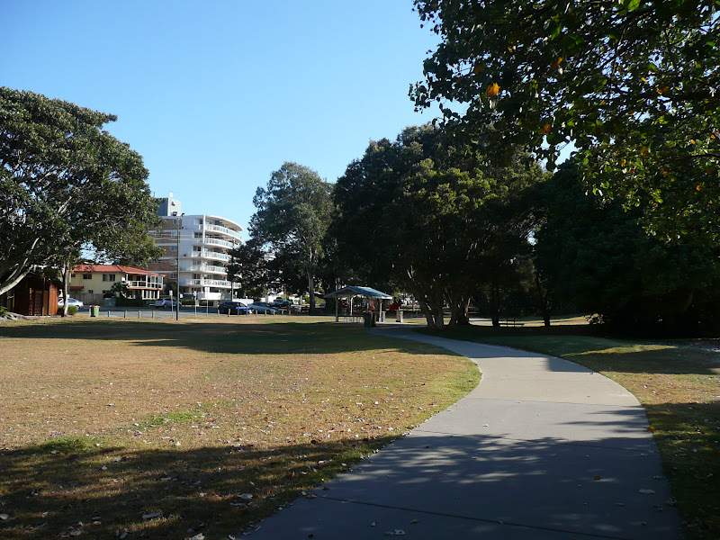
The town sits on the banks of the mighty Tweed River, some portions of which are given over to lovely parks and gardens


in which a careful search may reveal an exotic bird or two.  (she was actually looking at a local map before we headed over the bridge and into the town centre from the nearby information centre)


And this area of the park houses a BBQ shelter which I thought was decorated just as it should be in this part of the world.


The banks of the Tweed are dotted with many holiday homes and permanent residences, particularly on the southern side of town.  We were particularly taken by the setting of the local YCA Hostel.  What a place in which to drop one's backpack for a few days.


But like all the great eastern coast rivers, the Tweed has its darker side.  Most of these rivers have huge catchment areas in the order of many thousands of square kilometres, so, as you would expect, heavy rains can create havoc as the rivers burst their banks.  Murwillumbah has seen its fare share of inundation, a phenomenon which has now been largely prevented by the erection of a massive levee wall, which starts here and runs for a considerable distance north along the roadway. 


As we had, by now, come to expect in Murwillumbah, the local decorators had been at work to significantly beautify what would otherwise be a grey concrete mass.  The various  local nature themes presented along this levee wall were beautifully done and a were great advertisement for what is on offer in the district.  Clever stuff.


And what a district it is.  As I have mentioned previously, our visit to the town, and in particular the Information Centre, has whetted our appetites to see much more of the beautiful Tweed Valley and its surrounds.  Let me leave Murwillumbah with a parting view of a small sample of what the countryside offers.


Maclean was our planned destination for the following day's trip.  We made our way back to the Pacific Highway and continued south


into an ever changing topography.  Gone now were the cane fields (promise...promise) as we entered the world of hills and valleys


and the lands of the macadamia and banana plantations.


En route to Grafton we passed though an area which was very familiar to us both and, I am sure, to Mum and Harry.  A small nostalgic pictorial offering for the folks at home!

 
Now back to travel plans for the day. Note 'plannned'.  We had previously visited Maclean, this 'Scottish Town in Australia' when staying in Iluka three years ago, to cast an absentee vote of all things (the polling booth in Iluka was somewhat challenged in this regard which we found particularly odd given that it is a real tourist mecca).  In any event, apart from the novelty of seeing all the light poles painted in the colours of a myriad of clan tartan colours, the town itself is really charming.  Just the spot for an overnight stop and a wander. 
 
Enter plan 'B'.  The caravan park in Maclean is so small that we would not have been able to manoeuvre our rig through the entrance driveway let alone access our 'drive-through' site.  They were minuscule.  "Let's try Grafton".  A trawl through the caravan parks book, a 'fingers crossed' choice, and a phone call saw us booked in to the Glenwood Tourist Park and Motel in south Grafton, a locale which boasted serenity and large, drive-though sites.

Another find!  The park provided exactly what had been promised with the bonus that the couple who had recently bought the place and were very much in the throes of rejuvenating it, were absolutely charming and most helpful.  Sadly the grassed areas were struggling with a lack of winter rain and the fact that water restrictions had obviously limited the degree to which this could be overcome, but apart from that we were more than happy with our camp, here seen in the early morning mists of the following day.


Despite the fact that we have never visited Grafton itself, and, from what we had learnt, there is much on offer in this historic town, we decided that we had had enough for this day.  The tug remained hitched and we settled into a late afternoon happy hour before a fine evening meal and early night.  Sawtell beckoned....the second of our two current favourite destinations.


Sunday 23 September 2012

RAINBOW BEACH-INSKIP POINT (10 SEPTEMBER)

For a number of years now, Liz and I have wanted to visit Rainbow Beach.  During our stay in Caloundra we took the opportunity to just that, and, as I mentioned in my last blog, had an unexpected adventure whilst doing so.
 
Rainbow Beach is a small town located some 65 kms north-east of Gympie and approximately 140 kms by road from Caloundra.  It is so named for the rainbow coloured sand dunes which back the long stretches of pristine sand washed by the Coral Sea.  Immediately to the north lies Inskip Point and directly beyond that, across a narrow waterway, is Hook Point, the southernmost tip of Fraser Island.
   

The drive in to Rainbow from Gympie brought with it a real surprise....expansive pine forests and log trucks.

As we explained to Lyn and Steve who were with us for the drive, we could quite easily have been driving in the south-east of SA.  It was eerily similar and completely unexpected. 


We had received varying reports about Rainbow Beach, mostly that it was a tiny holiday village, a bit rustic and quiet.  So for our second surprise of the day.  The place was jumping.  One of the local shopkeepers did tell us that it was unusually busy, but nevertheless, the infrastructure in what is indeed quite a small town, was not what we had expected.


The short, wide main drag hosts a number of shops, restaurants and cafes, including a surf wear store and clothing boutiques which would not be out of place in the more exotic (and expensive) locales such as Hastings Street, Noosa or the rip off dens of the Gold Coast.


Large and obviously new holiday apartment blocks, the caravan park and a new, very up market pub are also features of the main street which ends (to the east) on the cliff top overlooking the Coral Sea.  And here I found the local Surf Club and RSL, inspirationally (I thought) both combined in the one building. 


The surf club had been recommended to us by friends who had recently stayed in Rainbow as being the place to go for drinks and a meal.  Good call!  Whilst we did not actually stop for either, a quick look around revealed that the club's bar and restaurant have been the recipients of numerous awards of excellence.  Coupled with the fact that the view from the balcony, perched high above the vast sweeps of the beach to both the south and the north, was nothing short of stunning, this is indeed the place to go.  Next time, and there will be a next time...Rainbow Beach is definitely on the 'must stay' list.
 
A walk to the headland viewing platform at the end of the street provides views to the south which just included a glimpse in the distance of the coloured sand cliffs for which the area is renown,
   
  
and to the north where, given it was a week day, I was quite surprised to see an active surf patrol set up on the beach.

 
With a good eye on the tide, it is possible to drive along these stretches of beach for over forty kilometres. As can be seen from the tracks here at the Rainbow Beach access point, this is an activity which is particularly popular.  In fact, it was interesting to see the number of car wash facilities, both here and in Caloundra, which advertise the capacity to cater for full under body washing. 


Our visit to the headland also provided other points of interest, the first of which was the local returned services memorial.  Whilst the memorial itself is quite simple, as can be seen, its setting, looking out across the Coral Sea and along the beaches to the north and south from this relatively high vantage point, is simply stunning.


Just to the south of the memorial we came across a mounted ship's propeller with an accompanying plaque which briefly detailed the fate of the good ship 'Cherry Venture'.  My appetite for the unusual was truly whetted, and what a tale I uncovered.


On 6 July 1973, the Cherry Venture, a 1,600 ton freighter, was making here way unladen from New Zealand to Brisbane when she, and her crew of twenty four officers and men were caught off Double Island Point in what was described at the time as a storm which was "the worst in living memory".

A 140 kph gale had whipped up sea swells of over 12 metres in height.  Unfortunately the skipper of the Cherry Venture had ventured (sorry!) too close to Double Island Point to make safe passage past it.  His empty ship was at the mercy of the relentless waves and wind.  Attempts to make headway further out to sea were unsuccessful.  With each passing wave the stern of the empty ship was flung high out of the water, the screw chewing at nothing but air.  Both anchors were dropped in an attempt to hold ground, but when the cables snapped in the atrocious conditions, the fate of the Cherry Venture was sealed.
 
The ship was quickly driven ashore at Rainbow Beach where she remained at the mercy of the pounding seas.  Whilst the crew survived the grounding, all the lifeboats were swept away, not that there would have been any real prospect of a successful launch in any event, as this borrowed shot shows.  RAAF Iroquois were launched from the Amberly Airforce Base to attempt a rescue.  The fact that they actually reached the area in the appalling weather conditions is another tale of supreme flying and navigation skill in itself, but suffice it to say that by the time they had arrived the crew had been taken off the ship by using Breeches Buoys rigged to the shore. 
   
 
Despite all attempts to refloat her, the Cherry Venture remained high and dry.  As could be expected, she became a significant tourist attraction for many years, until the deteriorating condition of her rusting hull posed a real threat to those who insisted on climbing all over her.  Her skeletal remains were finally removed from the beach and her prop mounted were we found it .   Another one for Lloyds of London!

 
And the saga of 'sand and stuck' continues, but this time much closer to home.  Rainbow Beach lies on the southern end of a relatively narrow sand peninsula which ends some 10 kms to the north at Inskip Point.  The road to the Point is bounded for much of its distance by tracts of bushland on which myriads of caravans, camper trailers and tents were dotted, all taking advantage of the free camping on offer.


And I have to say this all looked very appealing until we later saw many of these 'scrubbies' lining up at the water point near Rainbow Beach, all armed with an array of water containers of varying shapes and sizes, patiently waiting their turn at the tap in a scene which resembled something out of a third world country.  I was reminded of camping trips I made many years ago with my wonderful hockey team mates to the wilds of southern Yorke Peninsula, where we pitched camp on a sand covered limestone cliff overlooking Investigator Strait at a spot where our survival depended on humping all we needed by way of food and water (and other liquids) with us.  I must now concede to having become somewhat captive to the relative luxury of our van and the amenities of real caravan parks.
 
But I digress...on to Inskip Point and the extraordinary ferry which transports vehicles from here to the southern tip of Fraser Island.  And to a tale of the unwary.
 
The sealed road to the Point gives way in its last few hundred metres to a gravel surface which itself terminates at a sign warning that only four wheeled drive vehicles should venture further.  "No problem", thought I.  We are in permanent 4x4 drive.  Off we charged onto the wide sandy flats of the Point.  Or should I more correctly say the wide, deep, soft sandy flats of the Point!  The track out towards the embarkation point of the 'Mantaray' was deep and insistent.  Despite the fact that I had (naively) not let down our tyres (a must for really soft sand driving), we were committed.  All attempts to move out of this track onto what looked more forgiving territory, whilst maintaining sufficient speed to prevent bogging, were fruitless.  So, with a significantly increased heart rate, your correspondent piloted the trusty tug right across the flats to a point where to continue would have seen us ram a vehicle awaiting the arrival of the ferry, here seen in the distance in a rather unfocused shot as it made its way across the passage from the Fraser Island shore.


Frankly I had not been aware until this point that I was actually in the 'ferry line'.  There are no lanes, no docking points, no ticket men, nothing.  One simply drives across the sand and waits on the shore until the clearly purpose built and extraordinary looking 'Mantaray' drops its ovesized loading platform onto the beach and on you go!


The distance from which I took this shot, and the fact that the sand flats drop away at the water's edge, means that the front landing platform cannot be seen in its lowered position on the sand, but by looking at the rear platform, which is obviously still raised, hopefully you can gain some idea of how this thing works.
 
To me this whole landscape was surreal.  Four wheeled drive vehicles were scattered right around the parabola of the Point.  All were serving as the base for activities ranging from family picnics to those of clearly dedicated and well equipped anglers.  What a scene.
 
After coming to a halt I did then manage to escape the clutches of the track ruts.  We slowly made our way back towards the road entrance when, as you have undoubtedly guessed by now, the inevitable happened.  I could argue that my planned route of escape from the clutches of the Inskip sand was stymied by another driver who came charging onto the flats from the entrance road and forced me to slow when I was trying to maintain way, but that is really just an excuse.   By this stage our forward, wheel spinning, sand churning  progress had been steadily declining and the inevitable finally happened.....we were well and truly bogged.....to the chassis.  And, as I then discovered, the location of the Cruiser's spare wheel under the chassis frame, results in it acting like a ploughshare in conditions such as these.  Another lesson learnt. (the Mantaray is just visible in the middle distance in this sad shot)
 
  
The adrenalin of my annoyance proved a boon as I then stripped off and set to with my trusty travelling shovel.  As Steve helpfully pointed out, at least we weren't racing an incoming tide!  "Thanks mate".  Twenty minutes later, after the removal of (in my mind in any event...all the non combatants will dispute this figure) at least fifty tonnes of sand, with tyre pressures reduced considerably and all passengers disembarked, I steamed out of the sand in what Liz described as a spectacular display of rearward flung particles. (Silly duffer forgot to take a photo!)  I intend to return to Inskip Point, this time properly prepared.  Despite my ineptitude driving dispaly on this first visit, I found the entire area absolutely fascinating and completely unlike anything I had ever seen before.  And they were catching fish!


Thursday 20 September 2012

CALOUNDRA (9 - 14 SEPTEMBER)

We both loved Caloundra on our first visit three years ago.  "Would it be the same?", we wondered as we meandered south along the Pacific Highway from Hervey Bay.  Well, we are delighted to report that in this world of change, for us, some things have remained constant....we still love Caloundra, and all the changes we noticed were positive.  After the adventures of the past months it was a real treat to be able to navigate our way to our new home in Golden Beach without maps or computers. Driving into the town felt very much like 'coming home' in a sense.
 
 
Our new found friends, Lyn and Steve Eleftheriou, beat us to the park by about five minutes.  Steve's van is bigger than ours by a couple of feet (it is a whopper) and our side by side sites were pretty tight, but we jointly demonstrated our collective  backing skills and were both on and settled in no time with a minimum of shouting and angst (and more importantly, no damage).
 
 
Golden Beach is located at the southern end of Caloundra on the Pumicestone Passage, the strip of water which separates the mainland from the nearby Bribie Island. High rise apartments are a features of sections of the Esplanade (a tale about this later) and our chosen park is overlooked by several of these, which provides an unusual outlook to say the least.  One of the towers can just be seen behind the tree in this shot of the park entrance.  Strangely, this backdrop (or 'frontdrop' to be more precise) did not offend.


As I mentioned, this part of Caloundra lies along the western edge of the Pumicestone Passage.  Immediately to the east, Bribie Island stretches south for some 34 kms. Like Moreton and North Stradbroke Islands further to the south, Bribie is a sand island.   It lies very close to the mainland and, as can be seen in this 'borrowed' shot, ends in a long tapered strip at its northern extreme immediately south of the main Caloundra CBD. 
 
As can also be seen from this photo, 'The Pumicestone' at this end of the island features many sandy shoals and narrow channels.  Navigation through these waters at low tide in anything larger than a flat bottomed punt is not for the unwary, foolish or faint hearted.  But what a paradise for those who enjoy fishing across the flats or pumping for nippers and worms for bait.
 
  
And what a different picture a full tide presents, particularly on a still, sunny morning, here looking north towards Caloundra city in silhouette against a morning cloud bank,

 
 and here, looking south from the same spot.


A linear park runs for several kilometres along the shoreline of 'The Pumicestone' from Diamond Head in the south to Bulcock Beach and the CBD in the north.  We were regular users of this delightful facility and, indeed it forms for us one of the real attractions of this part of Caloundra.  To the north, the path passes the sections of the Esplanade which features a strip of modern high rise apartments, both private and holiday rentals,


amongst which can still be found examples of 'old Caloundra' hunched defiantly alongside their more imperious neighbours. 


To the south, the paths meander through mangrove boardwalks, stands of pandanus 


and on to the low rise Esplanade of south Golden Beach.  This walkway is not as 'flash' as The Strand in Townsville but has a variety and charm which we find is just us!  And is is well used.  The good folk of Caloundra, residents and visitors alike, can be found in their dozens every morning walking, jogging or cycling along this strip.  Mind you, as we have agreed, motivation comes much more easily when the 6.30 am temperature is 18 degrees and the sun is well up by that time. 

 
The southern section of the walkway takes one past the historic, but oddly short, 'Military Jetty'.   This area has particular nostalgic appeal for us in that the park in which we stayed on our last visit is immediately across the road from the jetty. 


 'Quaint' is probably the most apt description of this particular park. We both fondly recalled the horror we felt when we first arrived (given that this was to be our home for three weeks....including the five days of the UN reunion which was the reason for our visit) and looked down the two narrow, crowded rows of sites interspersed with permanent cabins and somewhat nondescript vans. "What have we done?". Well, this was our first real lesson in the caravan park law of 'books and covers'.  We had one of the best times of our travels here.  The park manager could not do enough for us (including allowing me to drill bolts into our annex slab to hold down one end of our annex), the permanents were universally welcoming (if not a somewhat eclectic mix), the facilities were spotless and the attached 'chippie' shop sold the best take-away in Caloundra.  By the end of the first week Liz had become the surrogate 'camp nurse' and I found myself advising on a wide range of legal matters (sadly, usually in the criminal field...we were rubbing shoulders with the odd rouge or two...but we have never had less concern in any park about our gear).  It was a real little community in which each looked out for the other.....we had a ball.  Mind you, given that we quickly adapted to the local dress rules where scruffy shorts, thongs and an optional top was de rigeur, mouths did drop when Liz and I presented at the front of the park in ball gown and full mess dress (with medals) on the evening of the formal reunion dinner!


Enough of this reminiscence...on with our walk.  Military Jetty lies just beyond the entrance to the main channel of the new (and or course in this part of the world, obligatory) waterways development, 'Pelican Waters'.


Overlooking the channel entrance off The Pumicestone sits this hotel apartment complex and herein lies the tale I promised earlier.  And what a typically Queensland tale may I say, even at the risk of appearing a little 'sniffy'.  Apparently the channel and the development of the land behind it was approved by the local authorities on the condition that the northern bank of the channel formed the southern limit of permitted high rise development along the passage.  And, you guessed it, this complex lies south of the boundary!  From what we were told by several locals, its approval created one almighty local storm.  Far be it from me to mention the dreaded 'white shoe brigade' mentality, deals and counter deals, and, heaven forbid, an exchange of coin of the realm.........!  And whilst I have to say the end result is not unattractive, it remains a very large thorn in many local sides, and is most decidedly the last of anything over two stories high from this point southwards to the extremity of Diamond Head where the Esplanade finishes.

Now, at this point, I must comment that I've not provided much of late in the way of 'local quirky'May I respectfully suggest that the sight of an Australian White Ibis acting as a weather vane on a suburban garage roof fits the bill!

 
Certainly not something commonly seen in Adelaide.
 
A walk north along The Pumicestone also provides some interesting sights and allows me to remedy another slight shortfall in my recent offerings....a dearth of 'big things'.  


This tower, to be found halfway between Golden Beach and the city centre on the eastern edge of the passage, is big.  I puzzled over its use for days until my local enquiries bore fruit. Believe it or not, this is a navigation light.  "For the Pumicestone????" I hear you ask. "Overkill" I hear you mutter.  Fair comment, but it is not for those intrepids navigating the passage in their assorted tinnies and stinkies.  This is  one for the big boys. 

Because of the sand banks and shoals which lie north of Moreton Bay, movement into and out of the main port of Brisbane by all shipping, large and small, necessitates passage along a very narrow channel which lies just beyond the western shore of Bribie Island.  The light pictured forms a lead with another situated on the island itself which provide for the safe passage of the vessels using the channel at a critical turning point. 

Indeed, one of the sights of Caloundra is that of enormous cruise ships making their way north out of Brisbane, particularly at dusk.  They pass so close to Bribie Island before turning west into the Coral Sea that all the upper decks can be clearly seen over the island vegetation from every first floor balcony along the Esplanade.  With their lights ablaze, and the need for reduced speed, the sight of these seagoing leviathans gliding silently behind the island  no more than two miles distant is a breathtaking spectacle. 

The walkway along The Pumicestone ends with arrival at the CBD.  Caloundra, as can be seen from the filched aerial shot included earlier, was built on the hills of the headland just to the north of the mouth of the passage.  Bulcock Beach, with its recently redeveloped quays and high rise apartments, cafes and restaurants


is what could be called the 'town beach'.  It is really the northern bank of the passage (here seen looking west to the quay)


which, as can be seen in this photo taken at 180 degrees from the last, lies just inside the mouth of the passage to the open sea at the northern most tip of Bribie Island.


Although this is a still water beach, the tidal flow can be quite strong at times.  In fact there are some local stalwarts who beef up their swimming training by deliberately splashing away against the tide, which, on a good day, can be running at up to three knots.

From this part of the walkway views back across The Pumicestone also include a glimpse of the tops of the famous Glasshouse Mountains, so named by Captain Cook in 1770 because their reflections and shapes reminded him of the glass manufacturing houses of his part of England at that time. 


They are indeed spectacular features, the remnants of volcanic plugs of rock so hard that each has remained whilst all around them has eroded away over the Milena.


Further around the point the walkway morphs into a boardwalk


which ends at Kings Beach, the first of Caloundra's open sea surf beaches (and the last with white sand) here seen looking south.


Kings Beach is a touch like Glenelg in that the surrounds boast holiday rentals, cafes and an open square area complete with water features and entertainment for the kids.


And like Glenelg, it is somewhat congested and parking spots are at a constant premium.  Here one will find the first of Caloundra's two Surf Lifesaving Clubs, Metropolitan Caloundra
 
 
The views from the glassed in balcony across Kings Beach and south along the western side of Bribie Island and the shipping channel into Moreton Bay from the dining and bar area of the club are magnificent.  As is the food.  We were hoping against hope that on the one evening we dined here there would be some action in the shipping channel, but apart from one tramp steamer, things were disappointingly quiet.
 
But there was a consolation of sorts.  Now I know you have all just been hanging out for another 'Pete knows everyone' story....well this is the first of Caloundra's two.  We had only just begun to eat when Liz looked up, gave me a nudge, and suggested that a chap about to order was someone I knew.  Sure enough.  Greg O'Neill is a retired SAPOL Superintendent of my vintage.  Moreover, Liz and I had shared a table with Greg and his wife at the PCOM Xmas function at the Morphettville racecourse last December.  And it gets even better.  After effusive greetings, Greg, who was in Caloundra visiting family (who incidentally do not live locally, but were here on holidays themselves), commented that it had only been a week or so previously that his wife had asked if he had heard anything of us and our adventures.  I suggested to Greg that much could be made of his dedication to fulfil his wife's every wish, even to tracking us down to Caloundra. 
 
And whilst I'm at it, the second of these yarns.  Two days in at Golden Beach Caravan Park a bloke from a mobile home some sites away wandered over to our van and enquired as to when I had been in Cyprus (he recognised the ribbon set).  To cut a very long story short, he had been stationed there as part of a twenty strong RAAF missile team working with the Brit airforce (the Brits maintained three airforce bases on the island) and had spent many a fine hour imbibing at the Australian Civpol HQ in Limassol  (a large Cypriot southern coastal town) in early 1971.  I arrived at Limassol in May 1971.  Whilst there was no personal recognition between us, we concluded that it was highly likely we may well have been in the same bar throng at some stage (and things did get a bit willing from time to time in our Mess) all those years ago.  How utterly extraordinary!
 
But back to Caloundra and the continuing tale of the local beaches (what else?).  Beyond Kings Beach and progressing further to the north around the Caloundra headland the white sand becomes yellow and gritty, a feature of Shelly, Moffat and finally the most well known of all, Dicky Beach, previously know as North Caloundra (or at least the surf club was).  Why Dicky Beach?...well the sign says it all,


and here is all that now remains of that good ship and true.


The surf club here is set well back from the beach.  It has a large membership and a very well run catering and bar set up.  We ate here a couple of times during our previous visit, and have since decided that the ambiance and views from the Met. Caloundra SLSC are much more to our liking. (no...still not homesick!!)


And notwithstanding the fact that Dicky Beach, here seen looking south towards the headland, is a fine beach, we both decided that it was Kings Beach for us (if we could only work out how to park easily!)


As I mentioned earlier, the headland area of Caloundra was the first part to be settled and now hosts a mass of high rise buildings (and others) on its hilly terrain. Even most of the lower of the multi-storey buildings provide views,


whilst the serious big boys certainly do. 
 
The main commercial street of 'old' Caloundra runs parallel to Bulcock Beach and few streets north of it, and although it is somewhat narrow and parking, of course, is a nightmare, we find it charming.
  
  
I would hate to give the impression that The Pumicestone, the beaches and the old CBD area are all there is to Caloundra.  Quite extensive 'normal' suburban housing areas extend northwards and to the west together with all the expected shopping centres and so on.  But, frankly, this can be found anywhere, so I've not bothered.
 
The RSL, Power Boat and Bowls Clubs all provide for excellent and relatively cheap nights out (complete with that wonder of the eastern states...the courtesy bus) and the public swimming pool with its 50 and 25 metre pools and inviting lawned surrounds, are other aspects of Caloundra which suit us down to the ground.
 
Let me conclude this part of our Caloundra experience with two dinners, both completely different, but which we enjoyed in equal measure for equally different reasons.
 
As I had promised the Elefth's, I finally broke out the frozen mackerel fillets which had travelled with us from Kurrimine Beach and we sat down to a fine meal of crumbed fish, mash and salad, chez Marshies.  And, hooray, I have finally found someone else who insists that beetroot is an indispensable ingredient of such a feast.  Cheers, Steve!
 
 
 Yes, I know, those bloody pants again. 
 
And for a completely different dining experience, we joined Julie and John Walker, our hosts during the UN Forces reunion here three years ago, for a sumptuous BBQ at their newly acquired unit on Kawana Island (some 15 kms north of Caloundra).  The ambiance (we sat overlooking the water), charming fellow dinner guests and great food and wine all served (only realised what a good pun this is during editing!) to provide us with a memorable farewell to what remains one of our favourite places in Oz.


Next stop, Sawtell, via Murwillimbah and Grafton.  But before we finally leave Caloundra there is the tale of the visit to Rainbow Beach and Inskip Point, where I embarrassingly had to prove that the shovel I carry is not for mere show and that I really do know how to dig the tug out of a bog.  Stay tuned!
 
P.S.  Apologies for the dicky photo placements.  As all who have blogged will attest, there are times when the victory is not worth the battle when the computer is in 'mind of its own' mode!