We had a decision to make, namely which route to travel between Capella and Sarina. The easiest option was to take the Gregory Highway north to Clermont, and then turn onto the Peak Downs Highway which would carry us all the way to coast at Mackay. From there it would be a short hop south to Sarina, a total distance of about 350 kms.
The main snag was that, with the exception of the stretch between Nebo and Mackay, we had done all these roads before.
An alternative presented....to head east out of Capella and take to coalfields road past Tieri and Middlemount, join the Fitzroy Development Road for the run north to the Peak Downs Highway, and then swing east off that major road to another secondary which would take us over the Great Dividing Range and directly into Sarina. This was some 40 kms shorter and new bitumen for us.
The discussion was brief.....today was to be a journey on roads much less travelled. This was to be a decision which did not please us later in the day, but I'll come to that in due course.
You may recall that we were all pretty well rugged up around the campfire the previous afternoon, and for very good reason.

The central highlands of Queensland can get very nippy at this time of the year, and whilst our departure skies were clear and the sun was shining brightly as we crept out of the caravan park and onto the coalfields road just after 0700 hours, the temperature was hovering at a seriously chilly 2 degrees C. The Cruiser's climate control system was hard at it, once the big V8 engine had warmed up!

Very soon after leaving camp we found ourselves driving past a section of the broad acre farming area which surrounds Capella where this paddock of sprouting sorghum glowed green (Emerald Green in fact!) in the early morning sunlight.

As we hauled along this first leg of today's trip of 310 kms, there was no need for a compass to tell us we were travelling virtually due east. The angle of the sun's rays gave the road surface the appearance of being wet, but in fact it was bone dry. Driving into this glare is no fun, and with the ever present threat of an encounter with a still sleepy, foraging roo, the speedo number through this section remained very low.

By the time we reached the Tieri turn-off, conditions had improved considerably, and we did briefly contemplate a quick detour, but we decided to push on on the basis we had seen coal towns when traversing the Bowen Basin a couple of years ago.
Out of curiosity I did later (yesterday actually) check out the Internet to see what we may have missed. The standard of the town website came as a real surprise. The photos and text made it

clear that this was a welcoming and well found little mining community which is actually a dormitory town for the nearby Oakey Creek coal mine.

A great deal of work has gone into making this an attractive and entertaining place for its 1,200 inhabitants to live.
All manner of sporting activities are catered for (including an Olympic sized swimming pool), the town has a good pub, adequate shopping and for those with a yen to camp and fish, swim or water ski, the Bundoora Dam caravan and camping grounds are a short thirty minute drive away. That's if you can tear yourself away from the excellent golf course!
I had previously read that the isolation, long shift hours and inherent danger of coal mining can easily take its toll on the workforce. Towns like Tieri, with pleasant surroundings and good facilities are critical to countering that. We had found the same travelling down the Bowen Basin previously.

It was not long past Tieri that the reason for its existence became abundantly clear as mining infrastructure loomed large over the tree lines in the distance ahead of us,

and, at points, closer to the roadside.

This is a busy and productive coal mining area as is all of the Bowen Basin.
Beyond Tieri we passed another town turn-off, this one leading to Middlemount. This was a name which was to feature heavily in the news before the end of the week, sadly for all the wrong reasons, as the death of a digger operator who was crushed beneath a collapsed wall was reported.
This was the third fatal mining accident in the Bowen Basin area over the past six months, and as you might imagine the relevant union was up in arms. It is a mistake to think that modern mining methods have eliminated all the associated risks.

By the time we had covered the first 95 kms of our journey, we came to the first of what would be several road junctions. Here we turned left to head north along the Fitzroy Development Road. At least this one had a name!

We had now left the coal mining area and found ourselves travelling through a rather dry looking landscape where large tracts of grazing land

were interspersed with the occasional agricultural paddock such as this one covered with the tall, dark brown, dry stalks of cropped sunflowers.

As we travelled further north the open plains country gave way to more heavily timbered road sides

and more undulating country. We did pass the odd road train or two, but on this stretch the width of the road presented none of the challenges of the single vehicle bitumen strips of the real outback. Here all I had to contend with was the wind wash of their passing.

After 100 kms north along the Fitzroy Development Road and with more significant looking ranges in front of us, we came to our next highway junction. Here a right turn took us onto the Peak Downs Highway, but the comparative luxury of hauling the van along this major road was short lived. We had less than 20 kms to go before yet another change of direction lay ahead of us.

On this section we had another reminder of the fact that the coal industry is spread far and wide in this part of the country, even if here it was limited to the railway line which connects the various mines to the huge port facilities at Hay Point, a place we were to visit in a few day's time.

With the ever steeper looking ramparts of the Great Dividing Range ahead of us,

we soon reached our next, and final, major road junction, where our destination actually appeared on the road sign.

We were now on the final leg of the trip with about 80 kms to run before we reached Sarina, but this was where things turned pear shaped. The road surface as it appears in this shot looks quite normal, but believe me this was far from the case.
This was one of the worst stretches of sealed road we had encountered for many, many months. The relevant section on our charts is now decorated with a very large cross to ensure we are never tempted to come this way again.

Occasional challenges like this creek crossing,

where the road was reduced to one lane, came as an almost welcome relief from the constant shuddering vibrations which rattled our rig as we made our way across with can only be described as a very badly corrugated blacktop. Even driving along the very centre of the road (where possible) offered limited relief.

But by now we were inexorably committed. We had no choice to push on, past yet another coal train

and on towards the ever closer ranges.

We did have some respite on a level section where the undulating country briefly plateaued but this was relatively short lived.

and by the time we reached this point, with the end in sight, we were well and truly back into mountain country, where the landscape all around us had morphed dramatically.....we had clearly returned to the tropics.
No crossing of the Great Dividing Range comes without its challenges. We have completed many, with and without the van, but frankly, having spent the time we did in Tasmania (and despite

rather ominous message conveyed on the notice of the times the bus would be traversing the range) I took this last section on with some gusto. We are now well seasoned hills haulers and at least here the road surface had become much more user friendly. In any event, for the next 20 kms or so we would not be travelling at anything much more than 20 - 30 kph.

So down we went,

twisting and turning, all the while descending though the now lushly vegetated slopes.

With more than three tonnes behind us, these speed advisory signs become irrelevant.
Descents like these are an individual challenge, and as far as I am concerned, always managed by keeping a hawk eye on the fluctuations of the speedo and tacho, feeling the movement of the van through the seat of one's pants and managing the gear range accordingly. Mind you, there is precious little we can do about the warning to 'beware of falling rocks', other than keep fingers tightly crossed!

But as I have said before, with steep roads come views, and the descent over the Sarina Range was no exception. We could well have been back in Tassie!

With the continuing demands of keeping everything on an even keel,

and under control from the requirements of both speed and highway positioning,

I rarely get to actually see these sights (other than an odd glance very much in passing) until the time comes to edit the photos taken by my travelling companion through the passenger side window.

With one last steep curve negotiated

our descent was completed, and we found ourselves back on 'the flat'

where Liz could not help but maintain her average by instantly snapping away at a sight we had not seen for some time.......the waving white fronds of sugar cane in full flower. Returning to 'cane country' is always a significant moment for both of us, despite the increasing number of years we have now done it. For us, I suspect it is something of a land version of crossing the equator.

Here tropical trees and plants had replaced the scrub of the outback (very much an observation not a criticism!),

and the railway line running parallel with the road was a narrow sugar train line replacing the much broader gauge of the coal trains tracks.

And finally, after a somewhat long and sometimes trying day on the road, came the welcome sight of the steam rising from the Sarina sugar mill.
After our numerous transits of this sugar town, and the sagas of Liz's (kidney stones) and my (earwig in the ear) visits to the hospital here in years past, our passage through the town was a simple matter,
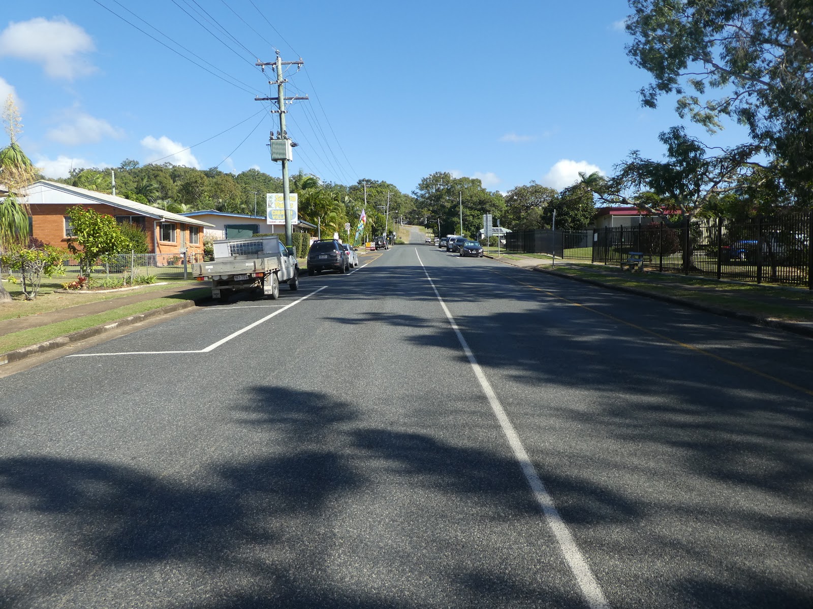
and within five minutes of coming off the Sarina Range Road we were cruising up Anzac Street

and coming to a halt at the office of the Sarina Palms Caravan Village,

where this very explicit notice in front of the office came as no surprise to us.
We had already been briefed that here, because of the narrow park driveways and dual entrances, one of the services on offer is that the park manager will provide personal guidance to ensure that all arriving vans are safely manoeuvred onto the site allocated to them (this is known around the caravanning world as 'a marriage saver'!).
Now Liz and I, after all these years, are dab hands at this, but I have to admit that today I was more than grateful that all I had to do was sit in the Cruiser and do exactly as the was told.