A few phone calls a week or so ago to our very close friends the Banninks had raised the possibility of a rendezvous with them for a few days at Lake Maraboon (17 kms south-west of Emerald). This was altogether too much to resist, particularly given that Hens travels with a topper (a small tinnie) and I still carried my redclaw nets. Lake Maraboon absolutely crawls with these freshwater crustaceans. Perhaps after all these years I might finally get to actually catch one!
This change to our original travel plans meant that several overnight stops which had been on our previous agenda now went by the wayside....we had to cover some serious ground.
Today was to be a very long one by our standards.....465 kilometres south through the Bowen Basin for the entire day from Collinsville to Capella, a small but very pretty little town through which we had travelled several years ago when heading north out of Emerald to Charters Towers.

Needless to say an early start was very much the order of the day. This one dawned still, cold and misty and as we hauled out of Collinsville it became very evident that the fine, clear weather of the past few days had deserted us, at least for the time being.
This was to be a day of constant reminders of where we were....smack in the heart of Queensland coal country.

Only a few kilometres south of Collinsville, the train loading facility of the Sonama Mine


and the twin conveyors heaping coal on the loading dump loomed large through the wan misty light of the early morning.
Well, we thought, this is not too bad.....a bit misty, but it could be worse. It soon was!

We had not travelled more than 10 kms out of Collinsville when we drove straight into a 'pea souper'.

This was serious fog. With fog lights on and the caravan clearance lights ablaze along both sides and the rear, we crawled along at no more than 30 kph for what seemed like an eternity

before the first break came and we had a stretch of sunlit road ahead of us.


This was serious fog. With fog lights on and the caravan clearance lights ablaze along both sides and the rear, we crawled along at no more than 30 kph for what seemed like an eternity

before the first break came and we had a stretch of sunlit road ahead of us.

We did encounter a few more patches of light mist as we made our way through the undulating hills now well south of Collinsville, and had I been less peeved about the delay (which was the last thing we needed on this long haul day) I would have had to admit this really was pretty scenery.

Our first creek crossing was soon with us.

Here the highway was definitely the 'low road' compared to the elevated rail crossing but metres away.

Not that there was too much water below us...the state of this river bed was testament to the fact that much of this part of the country was struggling with very low seasonal rainfall. It was somewhat odd to think that only a few days ago we had been travelling though areas which had been completely inundated by the massive dump from Cyclone Debbie...only in Australia!

By now the mist had cleared and we were charging ahead at a goodly clip,

but not for long. Where the hell did this lot come from? Again it was lights on and speed off

until, after more than 80 kilometres of frustration, we finally emerged into bright sunlight which, to my great relief, stayed with us for the rest of the day.

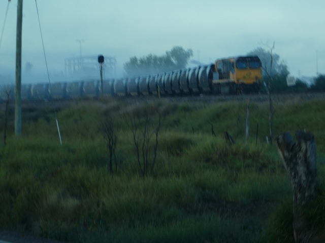
And of course the other thing which was our constant travelling companion for our entire trip were reminders of the fact that we were indeed still in coal country. Coal trains

and distant overburden heaps were very much the order of the day...all day!

Our first creek crossing was soon with us.

Here the highway was definitely the 'low road' compared to the elevated rail crossing but metres away.

Not that there was too much water below us...the state of this river bed was testament to the fact that much of this part of the country was struggling with very low seasonal rainfall. It was somewhat odd to think that only a few days ago we had been travelling though areas which had been completely inundated by the massive dump from Cyclone Debbie...only in Australia!

By now the mist had cleared and we were charging ahead at a goodly clip,

but not for long. Where the hell did this lot come from? Again it was lights on and speed off

until, after more than 80 kilometres of frustration, we finally emerged into bright sunlight which, to my great relief, stayed with us for the rest of the day.

And of course the other thing which was our constant travelling companion for our entire trip were reminders of the fact that we were indeed still in coal country. Coal trains

and distant overburden heaps were very much the order of the day...all day!

The landscape flattened out considerably as we made our approach to the first town through which we were to pass.

Glenden, about 120 kilometres south-east of Collinsville, is one of the purpose built mining towns to which I referred in my last post. It lies a short distance off the highway, and despite our rather full schedule, we were keen to pop in for a quick look, more in the nature of a recce for future reference, really.

What a lovely little town it proved to be. Whilst all the homes are of a very similar design, they are not unattractive. We had no sense of a 'matchbox city' here.

The town has been planned in such a way that there are no intersections. The tree lined streets all curve around each other and in this very short 'in and out' visit we saw that this is a town with excellent community facilities and one in which there is an obvious pride in its appearance.

As we took a quick break at the rest stop at the entrance to the town and the obligatory photo of the huge earth moving bucket which takes pride of place here, we both agreed that Glenden is now firmly placed on our list of places in which to spend more time in the future. And again we could not help making the comparison with what we had seen at the company mining town of Leigh Creek.....light years apart!

And it hardly seemed as though we had left Glenden when we came across another real surprise. This, I have to admit, was by accident. Some 25 kilometres south of the 'big bucket' we came to this junction where the sign to Mackay, and the departure of a mobile home from the road off to the right, created a temporary directional dilemma for the normally very street savvy Mobile Marshies.
I committed to the turn, and within short order we both came to the same conclusion....we were on the road to Lake Elphinstone which was not actually where we should have been going.
Quick as a flash the navigator piped up with a comment she still denies was self justification or a cover-up. "I think there is a free camp at Lake Elphinstone", was her cheery observation. Ah,well, now that we are here we might as well see what's on offer.

What a most fortunate blunder this was. There they all were, lined up along the lake's edge beyond the open stand of trees.

As we had done in Glenden, Liz snapped away as we virtually drove in and out, but even this very brief visit was enough to seriously whet our wanderers' whistles.
A subsequent trawl through our recently acquired 'Wikicamps' and a glance or two on the Internet told us that here the facilities include public BBQ's, toilets and showers. The lake is an ideal venue for kayaking, fishing and chasing redclaw. The spacious camp grounds are level and absolute lakefront views are here for the taking. This was more than enough to convince us that this is a must for a future stay.
But for now, it was back to the right road, and off towards the next town on the list, Nebo.

This next 50 kilometres leg of today's trip took us through a section of the Denham Range,

with all its undulations and the constant foreground of distant hazy hills.

On the outskirts of Nebo, whilst still some five kilometres from the town,

we reached our first 'highway' for the day. The Peak Downs Highway runs out of Mackay to take travellers the 275 kilometres south-west to a point where it intersects with the Gregory Highway just north of the mining town of Clermont. For us it was now a right turn,

and on through the town of Nebo, which like Glenden and others, lies a little distance off the highway. This is another the the mining towns of the Bowen Basin, with infrastructure which supports over ten mines operating in the immediate district.

With a permanent population of just over 1,000, Nebo is not a metropolis by any means, but it is home to a great looking pub as this photo courtesy of the 'couriermail' shows. What more incentive is necessary for a stop-over here on a return trip, I ask?

We had barely left the town precinct when another rail bridge provided yet another reminder of where we were. As I have mentioned before, these coal trains are huge. We were soon to learn just how big they really are.

The highway out of Nebo, with the electric rail line as a companion for many kilometres, now took us south-west

towards the next small mining town on our route, Coppabella, where another overburden heap dominated the approach view.

I had now been driving for almost two hours since our last break in Glenden. It was time for another, and what better spot than the small rest stop on the entrance road to Coppabella.
Leaving aside the fact that this is a charming little park into which to pull up for a while, it comes with a bonus for any who are keen to know more about the coal industry (well the coal trains at least and this particular town),

because directly across the road a retired coal train waggon stands proudly in Clough's Park, transformed now into an industry billboard.

I'll let your minds boggle to whatever extent you choose as you absorb these figures. Just look at the average total weight of these trains for goodness sake!

The stats on the town were equally informative. What did surprise us was the fact that this is a 'railway town' as opposed to a mining village, but when one looks at the number of trains which pass through here each day, it make some sense.
Yet another town to visit at a later date went on the list.

As we rejoined the highway with still over 190 to go (our destination for today is some 55 kms south of Clermont)
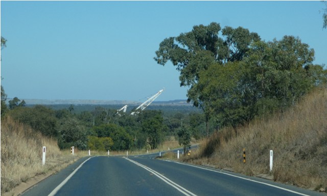
and breasted a quite long hill, we were confronted by an extraordinary sight. What on earth is this huge machine towering over the not insignificant tress ahead of us?

And the answer is......a massive dragline, and of course this answer merely raises another question....what the hell is it doing here sitting in the scrub with not a mine within cooee?
As luck would have it, whilst we were still pulled in off the road to grab this photo, the fortuitous arrival of one of the operators near the point where I was taking this shot enabled me to do some sleuthing.
It turned out that this gargantuan lump of moving metal was en route back to its normal place of operation. Apparently it had been loaned to another mining group during a slow time in activity at its normal site, and, because these things crawl around on massive great tank tracks, it had been carted off through the bush from one mine to another. I was suitably gobsmacked I can tell you.
This seems like an opportune time to detour quickly from our road trip and bring some perspective to all this mining stuff. Thanks to 'businessnews', this shows a typical dragline

excavator, of the sort we had just come across, beavering away in a typical open cut coal pit. This photo also shows a pile of overburden which is stripped away to allow easy access to the coal seams.
I am indebted to the 'couriermail' (again) for this shot of another open cut mine (near Moranbah, the next town we shall pass) which serves to show just how large these great gashes in the landscape can become.

I must comment at this stage that I am particularly peeved that my trusty aid Google Earth has gone down with some electronic ailment. An aerial view of these districts give a much better idea of just how many of these mines are active throughout the area. I am hopeful that my much skilled computer assistant (son Cameron) will be able to restore this function on which I so heavily rely before too much longer, when I shall revisit this matter.

But for the present, it was ever onwards south-west along the Peak Highway, where some serious infrastructure and yet another overburden heap in the distance heralded our approach to yet another junction, this time leading off to the right to the town of Moranbah.
This is the 'biggie' as far as the mining towns we had passed today are concerned, with a permanent population of nearly 10,000 and another 1,500 FIFO's coming and going regularly. Again, a town for a later visit.
Beyond the Moranbah junction, the landscape took a dramatic scenic turn with a series of massive granite lumps filling the horizon in front of us as we gazed across the green cropping fields

which had replaced the scrub through which we had been driving for so long.

These rocky outcrops reared upwards in all different shapes and sizes. Some formed lines along the skyline,

others stood aloof as couples

or in single solitary isolation.
What a change this all made from what we had been looking at for the past five hours or so. Just spectacular!

But as we plodded on along through the flat cropping landscape towards the Gregory Highway,

the ubiquitous 'man-made' hills of this area continued to dominate the scenery, but as a spectacle these came in a very distant second to the handiwork of Mother Nature we had just been admiring.

By now yours truly was beginning to feel a tad jaded. The Gregory Highway junction was a very welcome sight.

As we now made our way south-east towards Clermont, this massive roadside hill of overburden was a familiar sight....we had stayed in Clermont some years ago before travelling this highway north to Charters Towers. Today we left the town in our wake as we pushed on doggedly towards Capella.

In just less than a hour the long awaited sight of the outskirts of Capella came into view,

as did the sign pointing to our camp for tonight. But there was one important task to be completed first.

So rather than turn off, we mooched on through the town, past these magnificent bottle trees,

and the linear park which is a real feature of this spot (something we had also remembered)

until we reached the somewhat challenging entrance (after all this time at the wheel) to the local showgrounds. What on earth was this all about I hear you ask.

Simple, folks....for whatever else it might offer by way of good amenities, the Capella Caravan Park does not have its own dump point. Our head was but one visit shy of flashing its very insistant warning light at us. This was an important and very necessary detour if a later urgent and sleepy stumble to the camp amenity block in the dead of night was to be avoided!

Job done, it was back through the showgrounds portal where did not I need to be told to 'keep left',

until finally, after a very long day, we had reached our destination.

We had had the foresight to book a drive-thru' site in which there would be no need to unhitch, and our most welcoming host David led us to our allocated spot where we were able to drop anchor with a minimum of fuss. And would you believe it...here we found ourselves right next to another Roma, not only from South Australia but purchased from the same dealer as ours!
Contrary to my normal habit, I did not photograph this park, for two reasons. Firstly we plan to return to this delightful highway town at a future date when making much more of exploring the Bowen Basin, and

secondly, I was just too bloody knackered! Once the caravan legs were down, and power and water were connected, there was only one thing on your scribe's agenda....a long drink!
Tomorrow's run to Emerald and thence to Lake Maraboon was to be a doddle distance wise, but we had another problem to deal with before we went there.
Our air conditioner had begun to display an error message. We had identified a firm in Emerald which services the model we have installed in the van. This was ideal, but there was only a slight snag....to be assured of immediate attention we had to be on the doorstep at 0800 hours, so it was to be another early start on the morrow.
Another drink, tea and an early night were in the forefront of our minds....photos of the Capella Park (which is excellent by the way) would just have to wait.
No comments:
Post a Comment