From the time we began this nomadic lifestyle we have, where practical, tried to travel new routes as we head up, down and around the countryside. Understandably, as time has gone by the options to traverse new main Australian highways has become limited, so in those circumstances we compromise by choosing new places as our stop-over points.
But not always. There are some routes where the sheer distances involved, and our penchant for a maximum of a 250 - 300 kilometre travelling day, means that we must revisit old haunts. In other cases, we do so for the simple reason we particularly like the town.
Such was the case on this trip where we decided to break our journey east and north towards the coast at the 223 kilometre mark, which would bring us into Capella, a pretty little town which has always had an appeal for us and where we knew that we could comfortably drop anchor in a good drive-thru site with a minimum of fuss.
Well, that was the plan at least.....it had been almost two years since we were last here....fingers crossed nothing had changed.

Well, that was the plan at least.....it had been almost two years since we were last here....fingers crossed nothing had changed.

So from Alpha it was back to the Capricorn Highway which would take us east, past the gem fields of Anakie, Sapphire and Rubyvale, on to Emerald where we would leave the A4 and turn northwards to Capella.

This was still new highway for us, but today we knew that the Drummond Range lay between us and Emerald, so unlike our experience of a couple of days ago, the ridges across the distant skyline did not come as any surprise.

Most of the land through this area is used for cattle grazing. Despite the drought which was gripping so much of the country, the grass between the trees through this stretch was quite high and thick, albeit brown and dry looking.
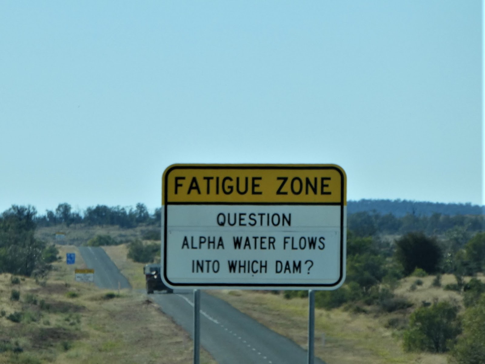
For some reason which we could not quite fathom, this section of the Capricorn Highway is a recognised fatigue zone, and as we had found elsewhere in Queensland, the authorities have made an effort here to stimulate tired minds with roadside trivia,

but in this instance, unlike any we had come across before, the question was followed (after a few kilometres) by a hint. I have to admit that we quite enjoy these little highway games, but not because we have ever needed to be shaken out of the lethargy of a long run....our self imposed travel limits have meant that, with the rare exception, our brains have always been alert and active.
Ah, you were expecting the next shot to provide the answer, weren't you? No such luck, you'll have to read on!

The ramparts of the Drummond Range presented themselves some 80 kms out of Alpha, about half way towards Emerald, and despite some annoying roadworks, we scaled the heights and crossed without incident or fuss.

With another 60 kms or so under our wheels, we reached the turn-off to the three gemfield towns which lie about 45 kms or so west of Emerald. We've yet to spend anytime here, but having taken a day trip to the area some years ago (in May 2013 actually!) whilst staying in Emerald, Rubyvale in particular is on our 'to do' list.
It was also during that visit that we fell for the trap of thinking that Emerald had been named after the gemstone, which is completely untrue. In 1869, one P.F. MacDonald established a grazing run in the area. He was so impressed by the green hue of his pastures, he named his property Emerald Downs from which the town eventually took its name.
Who needs roadside trivia when you can tune in to the Mobile Marshies?

Before reaching Emerald, we were passed by travellers of another stamp, seated in creature comfort in the carriages of 'The Spirit Of The Outback'. This twenty-six hour train trip from Brisbane to Longreach is one which is considered to be up there with the Indian Pacific or the Ghan, notwithstanding the fact it is considerably shorter.

Within less than another fifteen minutes we found ourselves in the bustle of Emerald traffic, but not for long. Fortunately our familiarity with the town meant that we had no trouble finding the highway junction where we would take our leave of the A4, which continues on east to Rockhampton, and join the A7, the Gregory Highway, for the last 55 kms of the trip north to Capella.

Once in the main street of the town and whilst en route to the Capella Caravan Park we passed the sign showing the road to Tieri and beyond. This was to be our route tomorrow, but for now

it was further north to the entrance of the caravan park

where we were soon directed to our site, one right next to that we had occupied last time we were here.
I recall that on that occasion, in August 2017, we had driven an unusually long distance (for us) south through the Bowen Basin coalfields, over 450 kms from Collinsville. After setting up all that was on my mind that afternoon was a chair in the shade and a very long drink, but on this occasion we were both much brighter.

A daily afternoon happy hour around the camp fire is a feature of this park during the cooler months, and today we were more than keen to join the throng and swap the inevitable travellers' tales. As you can see by the way everyone was rugged up, the fire was lit for more than mere 'atmosphere'!
Before ending our day here around the fire, we did take an earlier opportunity for a quick jaunt along the main street.
This was actually the third time we had passed through Capella, and as is so often the case, I could not fault the description presented by 'Aussie Towns', which notes that, "Capella is a tiny township with the appearance of being a single street with houses and shops stretching along it."
The area around Capella was first explored by the ill-fated Ludwig Leichardt and as a result of his good reports graziers took up large runs in the 1860's. For many years Capella served as a small roadside stopping point between Emerald and Clermont, a mining town to 60 kms to the north, until a rail line connected these two larger centres in the late 1800's.
Why the government of the day took the action it did I cannot discover, but in what seems like a touch of early Australian socialism, things changed in the Capella district from 1883, when the large pastoral runs were compulsorily resumed and parcels of land were offered to small cropping and dairy farmers.
Capella, purportedly named by the area surveyor Charles Gregory after the brightest star in the constellation of Auriga (for what reason no-one seems to know), went on its comfortable, sleepy way for many years until, in the 1950's, the Queensland British Food Corporation introduced large scale grain production to the area......or at least they tried to!
Typical of so many agricultural projects or experiments in Australia's history, our fickle weather brought this one to its knees with a run of poor seasons. But all was not entirely lost. New crops, particularly sunflowers and sorghum, were introduced with a large degree of success.
Later, in the 1960's, the area surrounding Capella was the subject of large scale scrub clearances (try doing that in Queensland these days!), which led to a real agricultural expansion with broad acre plantings of the new, successful crops. This in turn led to the need for, and development of, bulk storage facilities and other local infrastructure, and Capella was on its way.
The 1982 discovery of coal at nearby Tieri, some 35 kms east of Capella, provided a further boost for the region and the town, and today Capella, with a permanent population of about 1,000, is an important service centre in a rich agricultural and coal mining area. Indeed there are now nine coal mines operating within an hour's drive of the town, something we were to see for ourselves on the morrow.

In addition to all this commercial activity, Capella also sits within sight of the spectacular Peak Range, where large volcanic plugs rise out of the flat surrounding plains to present spectacular sights (thanks to the website of the 'Southern Great Barrier Reef' for this photo)
We had unknowingly (at the time) photographed many of these as we drove into Capella two years before, and we both agree that the comparisons made between these and the Glasshouse Mountains of the Sunshine Coast area are completely apt.

Capella's long main street presents a mixture of buildings which are consistent with the history of its development.

Here modest little premises, such as the town Post Office,

and the local pharmacy

rub shoulders with the much more modern Dooleys Tavern

and the large town motel.

The Capella Hotel, a reincarnation of the original on this site (yep, you guessed it....this is Queensland and it burnt down!), occupies a prominent position in the street,

whilst the improved town infrastructure now includes, amongst other things, a fine swimming centre.
But it was what is to be found on the opposite side of the main thoroughfare which was of far more interest to me.

A memorial park of some sort is a common sight in most Australian country towns,

but here in Capella it included something unique to this town, apart from this quite moving avenue of honour.
Within the confines of the park is this spectacular tribute to that unique and famous Australian fighting force, the Light Horse (thanks again 'Aussie Towns' for a much better shot than mine),

but interesting as this was in itself, it was what I found on the plaque nearby which really caught my attention.

Apart from what I found to be the fascinating explanation for the hat band plume unique to the Australian Light Horse (and from later research I have concluded that this explanation is more probably true than not), here we had an unexpected and direct connection with the historical events which so occupied us in Barcaldine but a few days before. In fact I recall making the point then that although Barcaldine became the focal point of the strike, it actually began elsewhere, notably north of Capella.
Again, as I have so often commented, we continue to be fascinated by what we find when we nose around small country towns.
By now, after all our outback adventures, my actual nose was keen for the smell of salt and my ears were yearning to hear the sound of the surf once again. The coast was calling. Tomorrow, at Sarina, we would be but a stone's throw away, and back into cane country to boot.
And, just to show I have not forgotten.................here is the answer.

Your day is now surely complete!
And, just to show I have not forgotten.................here is the answer.

Your day is now surely complete!
No comments:
Post a Comment