One of the odd things about Mole Creek is that there is not, and never has been, a mole in sight! Trout, yes, platypus, indeed, Tasmanian tigers, certainly, echidnas, absolutely, but never a mole. This leaves the obvious question....why the name and how did it originate? We'll come to that shortly.
Firstly we were off to get some much needed exercise in the form of one of the many 'walks' which abound around Mole Creek...there are literally a dozen or so within a short drive of the town.
We had chosen to visit the nearby Alum Cliffs Gorge, about a five minute drive east from our park. This had been described in the relevant brochure as "An enchanting short walk (about 40 minutes return) to a forest lookout perched high above the Mersey River."
We've been conned before in relation to the described length and degree of difficulty of several Tasmanian walks, but in this case the description and reality aligned.

The narrow roadway off what becomes the B12 east of Mole Creek, snaked through quite dense timber until we reached the car park

where another of the ubiquitous Tasmanian '60 Great Short Walks' greeted with the news that the walk was indeed a gentle climb and that stunning views of the Mersey River and parts of the Great Western Tiers would be our reward. We shall see!

Well, they got the first part right. The track began with a set of bush steps which presented little challenge to your scribe's aged and deteriorating knees and took us through a stand of quite large trees, remnants of the dense forests which covered this entire area when it was first settled (more of this later).

'A gentle climb' remained the accurate description of the track as it emerged into more open scrub

and took us past this odd standing stone (don't ask...I have no idea and could discover noting relevant about it!)

before we made the final (still gentle) descent to our destination,

the viewing platform perched high above the cliffs. And I do mean high.
I really do love it when what is promised is delivered, and here at Alum Cliffs the views out over the gorge through which the Mersey River meandered (not that it had any choice in this topography) were indeed 'spectacular'.

Even the fact that there was but a trickle in the stream below did not detract from the stunning vista.

Sadly the limits of my photographic equipment prevented me from being able to capture the cliffs on both sides of the lookout at the same time. So, here is what we could see to our left.

This late afternoon shot I filched from the 'net' does present a much better view of the narrowness of the gorge and the height of the almost sheer cliffs either side.
This walk had indeed been worth the little effort it took. But we were in for yet another surprise.

I had only taken a cursory glance at this strange looking collection of beams when we had first walked past, but now it was time to pay more attention to this odd looking construction.
We eventually found a small plaque which provided the much needed explanation, one which I would never have come to without help in a hundred years.
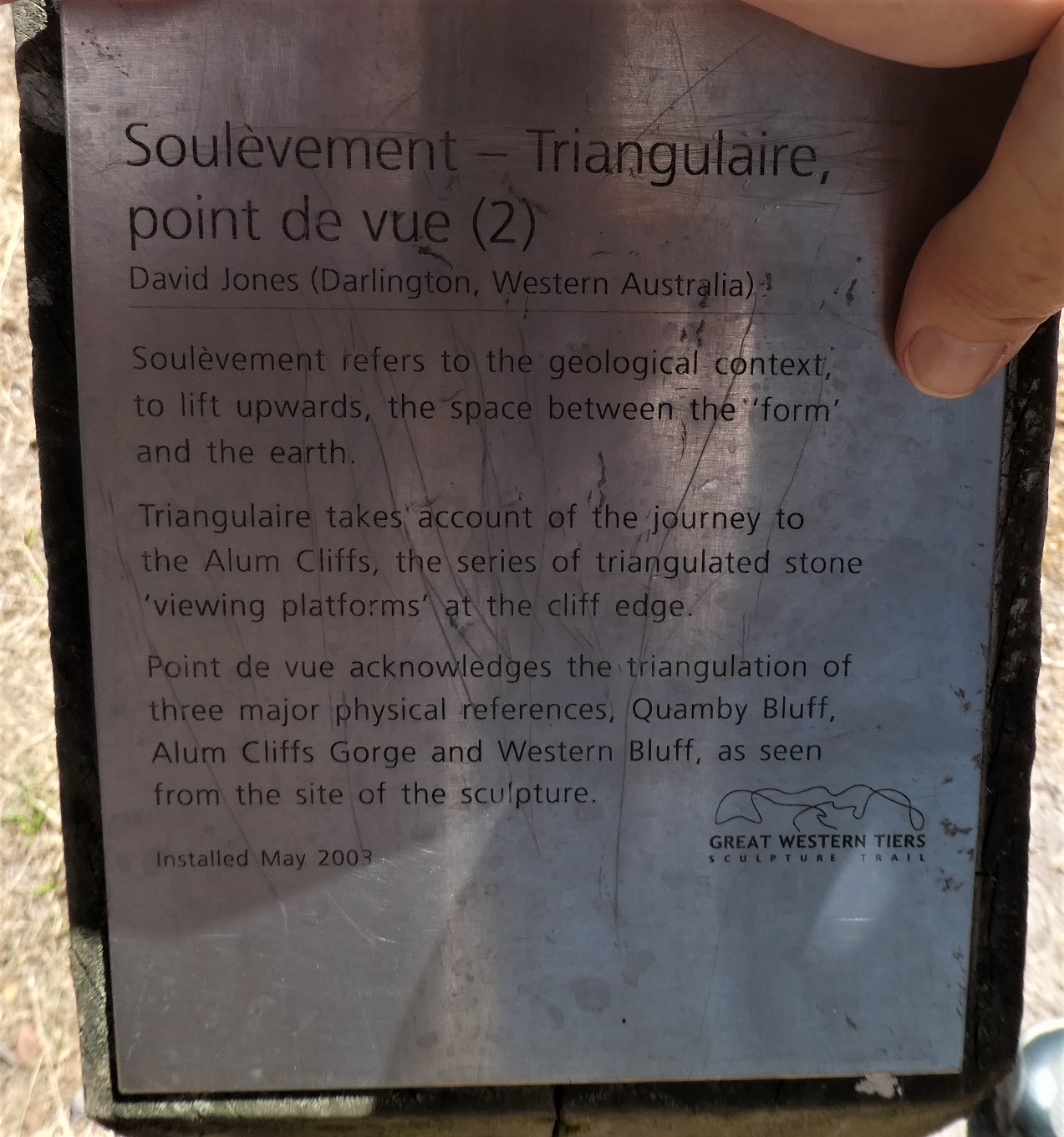
I am aware that I do have a penchant for the word 'esoteric', but would have to argue that never have I used it more aptly than now.
But there is more. I have since discovered that this 'work of art' is one of fifteen different contributions made by various artists to the 'Sculptures of The Great Western Tiers', offerings which are dotted throughout the area, particularly on the road from Deloraine to Mole Creek. We were to see more of these on the banks of the river at Deloraine next month.
I vaguely remember mentioning in a previous offering that a number of my Mole Creek town photos have gone astray somewhere in the electronic ether (or should that be 'the cloud'...where do they get these names?!). But I have retained a few, and I've pinched a couple to add to the final pictorial brew.

This is the view looking west along Mole Creek's main street (the highway as is so often the case in these small towns) as we drove in from Alum Cliffs.

At this end of town a small group of shops includes the original town 'general store' and its more modern counterpart, the Mole Creek Supermarket'. The town 'servo' is just out of shot.
The Mole Creek Hotel and a few local B&B's and other forms of visitor accommodation are located at the other end of this strip of commercial premises. And speaking of the pub, I did discover a fascinating snippet after I had blogged our stay there.
This famed watering hole actually began life as a guest house. When the nearby King Solomon's Cave was discovered at the beginning of the 20th Century, the bloke who grabbed the lease on it, the enterprising Edward James, also built a 30 room guest house over the period 1907-8, but due to some quirk of the law at the time could not serve alcohol. Part of the building was even used as the local grocery store for many years.
Believe it or not, the situation did not alter until 1953, when a licence was finally granted. It was probably just as well the building was originally named the Mountain View Guest House. Had 'hotel' been included in the title, it would have most certainly been Australia's first genuine 'pub with no beer'....and a record holder at that'!
But I digress...back to the town itself....and its name. I have not forgotten!
Let me introduce you at this point to the word 'karst', a word which is used to describe a topography which features underground drainage, caves and sinkholes, a system formed by the dissolution of soluble rocks such as limestone, dolomite and gypsum.
These land forms are to be found throughout Tasmania, an end result of the fact that much of the island was actually the seabed some 500 million years ago.
As this map shows, the area around Mole Creek is a Category A system, and the caves were shall visit shortly are a product of this phenomenon.

But, I hear you shriek, what on earth has that all got to do with the name of the town?
Well, everything really, because the little Mole Creek which runs through the area, was so named because it constantly disappears underground only to re-emerge after a short distance, and then vanish again as it makes its way through the local karst topography.
Just like a mole!......a conundrum solved by a geography lesson.
The district around Mole Creek was settled in the late 1800's, when it was a mixture of tall forest, open plains and boggy marsh. Many of the original settlers who came to this area once it was opened for development, were ex-convicts who set about felling the timber and establishing small farms.
The discovery of the cave systems brought tourists to the area as early as the 1850's and this remains an important local industry, along with forestry and farming, and, unsurprisingly, given the locale, a large limestone quarry.
But the product for which Mole Creek and neighbouring Chudleigh are best know (apart from the caves) is honey. In 1918, a local lad who had kept bees as a hobby before he went off to war, maintained his interest when he returned. He went on to open a commercial enterprise in Mole Creek, and within five years the 'Golden Bee' brand was a flourishing business.
Today Robert Stephens is remembered as the father of a local industry which accounts for about 35 percent of Tasmania's entire honey production (and they do produce a heck of a lot of it on the island), including the renowned Leatherwood honey, unique to Tasmania, one which is, we have been told, a decidedly acquired taste.
And now I must cheat a touch to complete our quick town toddle. Opposite the town's limited 'CBD', servo and very good swimming pool and public BBQ and picnic area (thanks to the Meander Valley Council for this shot)

the Mole Creek contribution to the Sculptures of the Great Western Tiers graces the roadside. At this juncture I must confess we were ignorant of the fact that this and the other piece of art we had come across on the Alum Cliffs trail were both part of this extended series, and this lack of knowledge continued in Deloraine where we inadvertently again 'joined the trail'.


A railway opened in Mole Creek in 1890 and although it only ran over a distance of 20 kilometres until it joined the Western Line at Deloraine, for many years it transported logs destined for the paper mill at Burnie or the chipping plant at Bell Bay.
In later years limestone was carried on this track to South Bernie for processing. This short 'extension' was closed in 1985 and the track has since been lifted, but during its heyday this line played an important part in the local Mole Creek economy and development.
And now that we have seen the town, learnt the origin of its name and the topography from which it was derived, and checked out the cliffs, it is time to visit the caves, well, two of them at least.
I vaguely remember mentioning in a previous offering that a number of my Mole Creek town photos have gone astray somewhere in the electronic ether (or should that be 'the cloud'...where do they get these names?!). But I have retained a few, and I've pinched a couple to add to the final pictorial brew.

This is the view looking west along Mole Creek's main street (the highway as is so often the case in these small towns) as we drove in from Alum Cliffs.

At this end of town a small group of shops includes the original town 'general store' and its more modern counterpart, the Mole Creek Supermarket'. The town 'servo' is just out of shot.
The Mole Creek Hotel and a few local B&B's and other forms of visitor accommodation are located at the other end of this strip of commercial premises. And speaking of the pub, I did discover a fascinating snippet after I had blogged our stay there.
This famed watering hole actually began life as a guest house. When the nearby King Solomon's Cave was discovered at the beginning of the 20th Century, the bloke who grabbed the lease on it, the enterprising Edward James, also built a 30 room guest house over the period 1907-8, but due to some quirk of the law at the time could not serve alcohol. Part of the building was even used as the local grocery store for many years.
Believe it or not, the situation did not alter until 1953, when a licence was finally granted. It was probably just as well the building was originally named the Mountain View Guest House. Had 'hotel' been included in the title, it would have most certainly been Australia's first genuine 'pub with no beer'....and a record holder at that'!
But I digress...back to the town itself....and its name. I have not forgotten!
Let me introduce you at this point to the word 'karst', a word which is used to describe a topography which features underground drainage, caves and sinkholes, a system formed by the dissolution of soluble rocks such as limestone, dolomite and gypsum.
These land forms are to be found throughout Tasmania, an end result of the fact that much of the island was actually the seabed some 500 million years ago.
As this map shows, the area around Mole Creek is a Category A system, and the caves were shall visit shortly are a product of this phenomenon.

But, I hear you shriek, what on earth has that all got to do with the name of the town?
Well, everything really, because the little Mole Creek which runs through the area, was so named because it constantly disappears underground only to re-emerge after a short distance, and then vanish again as it makes its way through the local karst topography.
Just like a mole!......a conundrum solved by a geography lesson.
The district around Mole Creek was settled in the late 1800's, when it was a mixture of tall forest, open plains and boggy marsh. Many of the original settlers who came to this area once it was opened for development, were ex-convicts who set about felling the timber and establishing small farms.
The discovery of the cave systems brought tourists to the area as early as the 1850's and this remains an important local industry, along with forestry and farming, and, unsurprisingly, given the locale, a large limestone quarry.
But the product for which Mole Creek and neighbouring Chudleigh are best know (apart from the caves) is honey. In 1918, a local lad who had kept bees as a hobby before he went off to war, maintained his interest when he returned. He went on to open a commercial enterprise in Mole Creek, and within five years the 'Golden Bee' brand was a flourishing business.
Today Robert Stephens is remembered as the father of a local industry which accounts for about 35 percent of Tasmania's entire honey production (and they do produce a heck of a lot of it on the island), including the renowned Leatherwood honey, unique to Tasmania, one which is, we have been told, a decidedly acquired taste.
And now I must cheat a touch to complete our quick town toddle. Opposite the town's limited 'CBD', servo and very good swimming pool and public BBQ and picnic area (thanks to the Meander Valley Council for this shot)

the Mole Creek contribution to the Sculptures of the Great Western Tiers graces the roadside. At this juncture I must confess we were ignorant of the fact that this and the other piece of art we had come across on the Alum Cliffs trail were both part of this extended series, and this lack of knowledge continued in Deloraine where we inadvertently again 'joined the trail'.

To my annoyance (and embarrassment) I cannot now accurately remember exactly what this offering presents, beyond the fact that the rock strewn, descending and curving path between the rock walls is representative of the flow of Mole Creek above and below ground.

The other inescapable feature of that side of the main road, this time opposite the pub, was far more obvious in its intent (and again Aussie Towns has come to the aid of this blog with the last two photos).
A railway opened in Mole Creek in 1890 and although it only ran over a distance of 20 kilometres until it joined the Western Line at Deloraine, for many years it transported logs destined for the paper mill at Burnie or the chipping plant at Bell Bay.
In later years limestone was carried on this track to South Bernie for processing. This short 'extension' was closed in 1985 and the track has since been lifted, but during its heyday this line played an important part in the local Mole Creek economy and development.
And now that we have seen the town, learnt the origin of its name and the topography from which it was derived, and checked out the cliffs, it is time to visit the caves, well, two of them at least.
No comments:
Post a Comment