We competed our Thargomindah stay with two more outings. Both involved visiting rivers, 120 kilometres apart, the Bulloo on foot and the Wilson courtesy of the horses under the bonnet of the Cruiser. And in visiting Noccundra on the Wilson River we stumbled on a real Australian mystery story.
The good burghers of Thargo have gone to great lengths to ensure that visitors to the town can amble along the banks of the Bulloo in comfort and style on yet another of the town's ubiquitous cement walking paths.
As this shot from 'Google Earth' shows, this particular path (very conveniently for us) begins at the southern edge of the Explorers Caravan Park and wends its way along the river bank past the

entire southern edge of the town. The area I've circled in red is the location of one of the town's highlight tourist spots, Pelican Point.
On our jaunt we left the pathway at the section where the it reaches the eastern side of the town oval from where we made our way onto Powell Street and back to our digs.

On our jaunt we left the pathway at the section where the it reaches the eastern side of the town oval from where we made our way onto Powell Street and back to our digs.

As we left the park and began our progress along the walking track, we came initially to the first of the very well presented information boards which can be found en route.
This one, in particular, provided us with a good overview of the Bulloo itself, its catchment and

the area of Australia through which it flows. This is a significant inland river system, but like so many others, only really flows during periods of high rainfall. Typical of some of these inland river systems also, the Bulloo does not flow to the sea but, when it is more than a series of waterholes, it empties into an ephemeral lake just north of Tibooburra.

For those contemplating a stroll by starlight (hopefully well protected against mozzies), an impressive looking solar lighting system illuminates the way.

Bench seats and tables are dotted along the path, and noting the improvised rock fireplace at this one, it would seem that impromptu bush BBQ's, or a cheery evening fire, is not discouraged.

As we strolled along here in the late afternoon the abundance of trees along this curving track were casting little but shadows, but they would provide a deal of very welcome shade during the hotter times of the year (which was certainly not now!). The short bridge ahead took us over a small side channel of the river

when we soon came across another of the walkway information boards. Again we were more than impressed with both the design and the detail it contained. These were another indication to us of just how much effort the local shire is expending on making a visit here well worth while.

Another sweeping bend brought us to the edge of the water,

at Pelican Point.

I detoured temporarily off the firm cement path and wandered down this access track,

from where I could gain a much better view of the extent of the water currently flowing past Thargomindah.

Just as had been the case with the Warrego River a few days ago, we really were seeing this watercourse at its best. This broad expanse was a far cry from the series of billabongs of the dry seasons.
The joys of fishing for yellow belly and netting for large yabbies in this region is one of the activities promoted in the tourist blurb. Looking at the colour of this water it never fails to astound me that the fish could ever find a dangling bait, but they do!

And indeed, just beyond this set of most unexpected sun lounges and more formal BBQ area (more than a mere pile of rocks to contain the fire)

we came across one of the residents of our park trying his luck on what was clearly a purpose built fishing access spot. This certainly beats having to bush bash down a river bank to wet a line! What would Thargo do without its cement plant??

The ruts in this river access road provided yet more evidence of the recent rains, and looking at this we could easily understand why several of the district unsealed roads (such as down to Cameron Corner) remained closed or had only just been re-opened.

At this point, with one last glance back along the pathway,

we veered off it and made our way up past the town oval where we were amazed to find that it could be lit at night by a series of light towers of considerable size.

Needless to say, in this part of the country, the goal posts were those of rugby league,

and although the supporting infrastructure was relatively modest, there was grass on the playing surface......and those lights! Extraordinary in a small town such as this.

At this point in our relatively short ramble we found ourselves wandering past the second of the two town caravan parks.

We had independently assessed this from afar when making our decision to stay at the other, and looking at what may have been, we were more than glad we had done so.
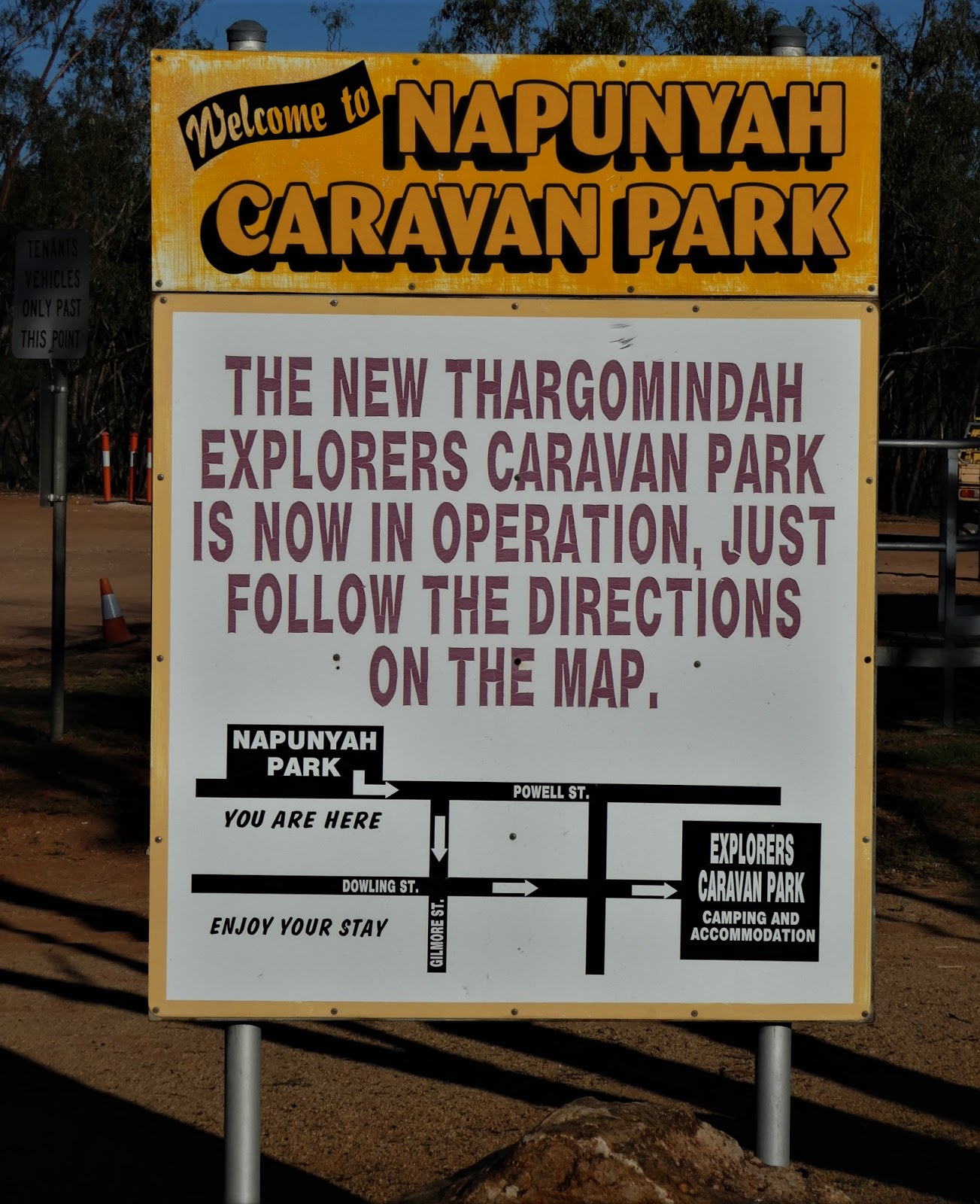
Just as we were applauding ourselves, we came to this sign. It was now obvious that this park is in its shut down stage during what we suspect is a process of easing what appeared to be long-term residents out of the park. Certainly newcomers were not encouraged.

Our last few steps took us past the large, modern shed which houses the town fire service

before we were back where we started at our digs, where our 'Warrego River' roses were continuing to provide a delightful splash of colour under our awning, and, a little later,

the molten glow of the setting sun bathed us in light of a completely different hue.
One feature of the river walk we had not seen (because we bailed out before reaching the end) was the old Cobb and Co. crossing. During the latter part of the 1800's, Thargomindah became the home for the coaches which took passengers hither and yon throughout the district.
For any who think that these were days of 'romantic outback adventure' this snippet from the excellent Bulloo Shire website may encourage a different point of view!
"If people feel that the road toll now is extreme, it was no bed of roses in the days of Coach Travel. Horses and men were spirited, and bolting and drunkenness were only two of the many hazards that had to be faced on the roads. Coach drivers and passengers had to contend with wild animals, unfriendly aborigines, and rough, potholed tracks. The high speeds of the very lightweight Coaches meant that any one of a hundred mishaps could occur, including rollovers.
Brake failure was common on steep, winding roads, and on many occasions the horses had to be urged along faster and faster to stay in front of the Coach.Sometimes the horses would shy at a goanna, a lizard, or some imaginary object causing all the horses to bolt. Even a broken rein could cause a bolt, and often the Coach would roll over, with fatal consequences.
The worst feature of Coach Travel was the discomfort of travelling long hours in extreme cold or heat seated on top of the Coach. Even an inside seat was no guarantee of comfort. For the outside passengers, overhanging trees were a health hazard. In the late 1800's, a Coach in transit from Cunnamulla to Thargomindah, with a full load inside and outside, was held for an additional paying passenger. Since all seating was taken, he sat among the luggage, and being of Chinese extraction he was not unduly discomforted. Somewhere between Cunnamulla and Suicide Creek, the Coach negotiated a bend, where many River Red Gums overhung the road. Consequently, the Chinese man was swept off into the forked clutches of the tree.
This trip of 150 miles, on a good road, would take about 5 – 6 days. Thus, when the Coach arrived in Thargomindah with a missing passenger 4 days later, there was concern, and a search party of Police and Black-Trackers set out to look for the missing passenger, knowing that few people survived for long in the harsh environment. The Chinese man was found, still in the tree, frightened, scratched, and a little thirsty. He had kept his sanity by talking to the trees and the birds. The remainder of his trip was completed on the back of the Constable's horse, with the memory of an experience he would never forget."
And whilst on the subject of Cobb and Co. in Thargomindah, and at the risk of having to admit to an odd sense of humour, I was more than amused to find a photo on a large information board the next day as we left town to make our way out to Noccundra......

.........feed for the horses being delivered by camel train!

This provides the segue I was looking for as we move right along to our trip out west to Noccundra. We did stop briefly to examine the large set of road signs on the Bulloo Development Road which was to carry us to our destination (well most of the way at least).

Here we more than gained the sense that we were right in the 'real outback'. Looking at this sign I was reminded of that (now) iconic song by The Dingoes, 'Way Out West' a yarn about a Queensland FIFO oil worker. As I noted previously, support for the gas and oil exploration and production are becoming an increasingly important part of Thargomindah's economy.

We were relieved to see that the road we were about to travel was open, and were more than pleased that Cameron Corner was not today's destination. We had, in fact, been speaking earlier to a couple in the camp ground at our park who were actually 'marking time' (less than patiently!) waiting for this road to open.

This major town information board which has been set up to greet visitors arriving from the loop road down from Eromanga, or the more challenging journey in from Innaminka, was located opposite the road condition signs.
The central feature of this display is an excellent shire map, one which puts this general area into

some real perspective, including the gas and oil fields, with the long term South Australian gas field at Moomba just west of the border.

So, knowing our way was clear, we were off on our road trip, one which would be just shy of 300 kilometres return.

We had barely left town when the sealed section of the road narrowed dramatically, another reminder of just where we were.....'development road' is invariably another name for 'narrow'!

Junctions on roads like this through country such as it is are rare, and invariably lead to one of two things....a station or a gas or oil field. This sign ahead indicated that we were about to pass the road leading to Norely Station, one of Kidman's at the turn of the Century.

Whilst much of what we were to traverse was pretty flat country, we did have to negotiate the Grey Range, a relatively low, but long line of hills which soon stretched across the horizon ahead of us.

We did cross several floodways, where there was no need for signs or height markers to identify them......the roadside grass and residual pools did that more than adequately.

Again we could only marvel at how clever our timing had been (in reality...coincidental would be a better descriptor!). After the recent rains we were seeing this country at its best. Our hopes for the Channel Country proper were high!

Mobs of grazing cattle were pretty pleased with the situation as well.

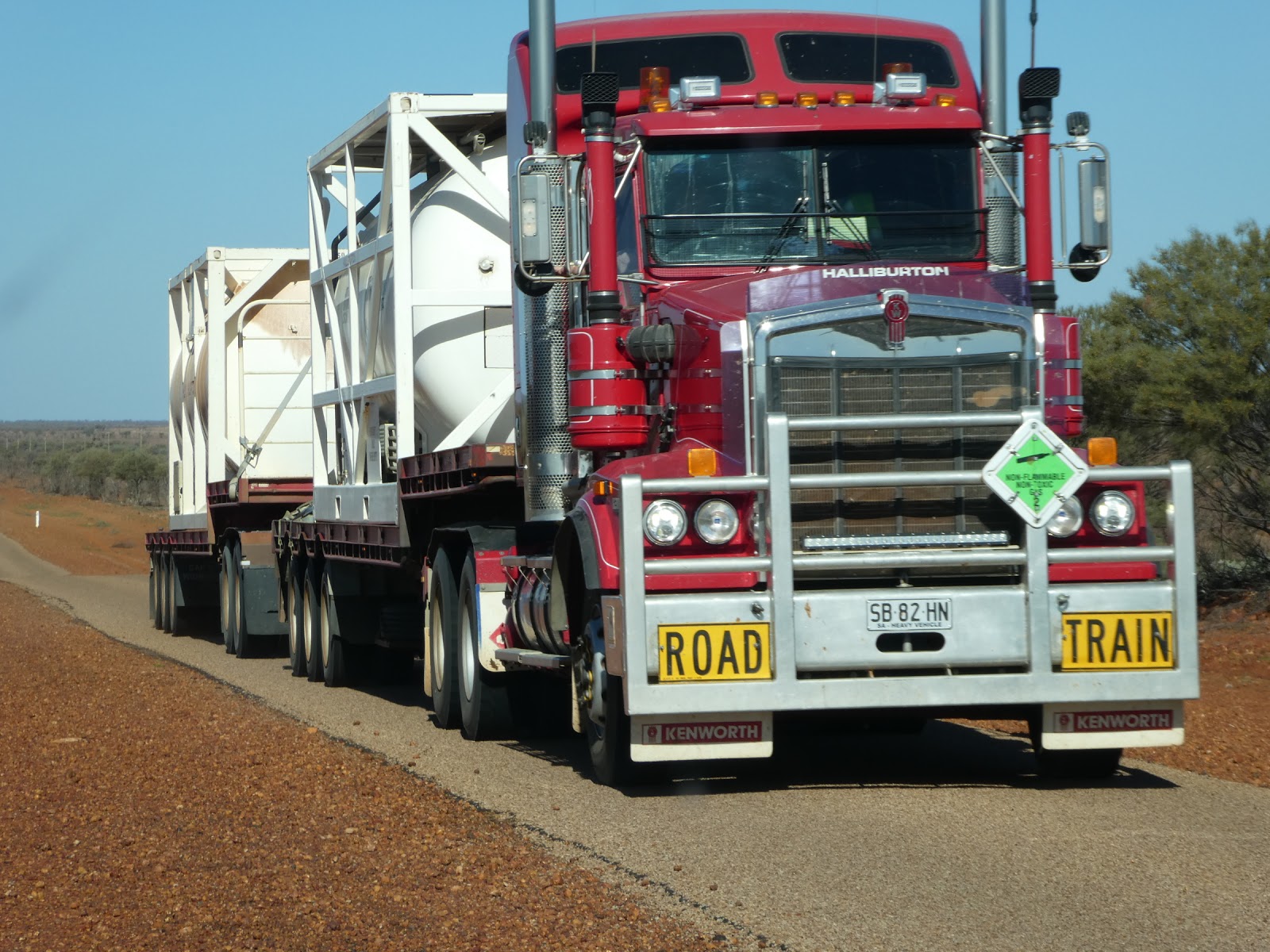
But elsewhere this road continued to remind us of just where we were. The plume of dust ahead was being kicked up by the wind created by the bulk of a fuel tanker making its way along this section where the shoulders had obviously been recently graded. Despite appearances, this truck was firmly on the bitumen.

As we neared, I was afraid we may have been stuck behind this monster for quite some distance, but fortunately, after a few minutes maintaining a respectful distance to the rear, we came to a short stretch where the bitumen was wider.
To my astonishment and delight, the most obliging driver in front of us actually slowed and pulled over sufficiently to allow us to pass. Never have I been more pleased to know the heavy vehicle highway blinker signal for 'Thank You'!

Much of the road through the undulations of the Grey Range was wider than the rest, a most sensible road construction precaution in a section where crests and bends do not give much warning of approaching traffic (which invariably out here is something which is bloody big!).

But once on the far side of the range, a sign in front of us gave warning that the road was about to narrow again as it stretched seemingly interminably through the low scrub into the distance.
Although narrow, I have to say that the condition of the road surface was excellent, and with so little traffic on it we were able to thunder along at a goodly clip. It had been some time since the Cruiser had been really given its head, and as I am sure you know, diesel engines appreciate a good workout from time to time.

After just over an hour this unexpectedly colourful sign told us we were approaching the junction where we would have to make a turn.

Not that we were planning to go to Tibooburra, Broken Hill or Cameron Corner, that is, but the first stop on the Warry Gate Road is Noccundra, and that was our destination.

How odd it was to think about the fact that we could take this road all the way back to Adelaide. Once we have swapped our current palace for a smaller and tougher off-road van (when we finally settle again) adventures over roads like this will be very much on the agenda.

With less than 20 kms now to go as we turned south off the Bulloo Development Road, we found ourselves in real gibber country,

where the flat, dry plains between the tree lines were a mass of harsh reddish rocks.


where the flat, dry plains between the tree lines were a mass of harsh reddish rocks.

It was across this unyielding and barren looking landscape that we caught our first glimpse of the tiny outback settlement of Noccundra.
But before we turned off the road and into the pub car park, we had to complete another short mission, to check out the nearby Wilson River and its camp ground, but before I bring you what we found there, let me again turn to 'Google Earth' for an overview shot of the area.
Although a grid of town streets has been laid out, very few have attracted any building development here in Noccundra (or probably more to the point, what was once there is now gone). As you can see, a short dirt roadway runs off the sealed road to take travellers to the banks of the Wilson River.

Here the land has been cleared to a degree to allow for open spaces to be occupied by those wishing to spend some time by this surprisingly wide waterway.


We were not entirely surprised to see this sign prominently displayed at the entrance to the campground and we did wonder how many of those who made this spot home for a while actually took any notice of it! The fact that it was necessary at all is a somewhat sad reflection on the reality of the hygiene (or serious lack of it) of many who camp in areas like this, not to mention the complete disregard these grubs show for their fellow campers.

And believe it or not, as we reached the open area by the river, here was yet another invocation to exercise common courtesy and good hygiene. We did wonder just how bad things may have been here from time to time to have prompted two notices, and I have to say we did keep a good lookout as we drove around!


As this shot shows, it is not far to walk (or drive) to reach the toilets from the camping area.....ah well!

On the day of our visit the place was empty. There was not a camper within coo-ee, something which did surprise us

given the fact that there was oodles of water in the river along this stretch.
But then I discovered that this is not unusual. The short Wilson River which rises in the Grey Range we had recently crossed (it only flows over about 30 kms in all) is part of the Lake Eyre Basin, and although its flows are strictly seasonal, the body of water along which the campgrounds are located is known as the Noccundra Waterhole, and it is rarely dry. Beyond here, the river spreads out on its way across the plains before it joins Cooper's Creek.
Despite its limited length and ephemeral nature, the Wilson River played a very important part in the development of the cattle industry in this area, and the development of stock transport routes.
Those tossing in a line at the waterhole can expect to catch Yellow Belly, freshwater catfish, and Spangled and Silver Perch, not to mention large yabbies between May and August. So where was everyone?

Well, there was plenty of evidence that folk had been camping along the banks quite recently. Fire sites such as this were dotted throughout, so we must just have come at the wrong time or on the wrong day!

As we made our way back to the 'town' we had the grand pleasure of a close encounter with a couple of feeding brolgas, who had their heads down searching for prey in this patch of surprisingly lush grass.

These magnificent and stately birds are anything but timid, and it was a few minutes before they realised that we had stopped to watch them, and even then they merely stood tall for a better look at us (briefly) before getting on with their lunch.

As the aerial shot showed, there is not much to this town but what's here did come as a real surprise. A large shed was not entirely unexpected, but the adjacent tennis courts were.......

.....as was this spacious building, the Noccundra Hall!
And then there's the pub, which we'll come to in a minute, but the question remains, why is this here? Again I'll let the 'Bulloo Shire' come to my assistance:
"Noccundra is located 142 kilometres west of Thargomindah on the banks of the Wilson River and contained within the pastoral holding of Nockatunga Station. The first Hotel in Noccundra was built around 1860 and burned down, which was a common fate of early western Pubs. The present Hotel was built in 1882 of sandstone, quarried from Mt Pool in New South Wales, and transported by Camel Train.
The Noccundra Hotel is all that survives of the town today, and was listed by the National Trust in 1977. It is an important link with the establishment of pastoral settlement in this area. It is one of the few early hotels actually built as an hotel to service the surrounding stations, it then developed into an important stopping place for Cobb & Co Coaches.
Noccundra Hotel has an unsealed Airstrip directly behind it, and many visitors fly in, park their planes out the front of the Pub, and enjoy a drink and a meal, then fly out again. Noccundra holds a Campdraft, Rodeo, Horse and Motorbike Gymkhana, and Bull Ride every October, as well as an Annual Race Meeting. The Noccundra Waterhole is a great fishing spot, and an ideal camping area."So there we are. A few early outback Australian stations with their very own pub.......they got their priorities right out here! In all our travels we had never come across anything like this before.
And it must have been seriously important to the lot living and working out here. The quarry which supplied the sandstone from which the hotel was rebuilt was located on a station some 30 kms south-west of Tibooburra, itself about 220 kms from Noccundra along the Warry Gate Road. So as far as I can roughly determine, camel trains carted building stone some 250 kms or so across what was then virtually trackless bush to enable this pub to be built! Surely this endeavour must go into the category headed 'only in Australia'!

After leaving the brolgas to get on with their feed, we headed up to the wide hotel car park to don the nosebag ourselves.

What a lovely little oasis we found,

with its thick sandstone walls and enclosing verandah surrounded by lawn and shady trees.

Before going inside to see if the meals here were as good as we had been told to expect, we took a quick wander around the hotel surrounds where I had spotted what looked to be a small memorial of some kind.
It was here that we stumbled across yet another of those extraordinary tales of the Aussie outback. The plaque told some of the story, but not all of it.

Andrew Hume is not to be confused with the 'Hume' of 'Hume and Hovell' exploration fame. This member of the Hume family was in gaol for horse stealing, when he made claims that he knew of a survivor of the ill-fated Leichhardt expedition who was alive and living with aborigines in the far west of Queensland. He was believed by at least one backer who arranged for Hume's release and provided him with the money to mount his own search party.
As is recorded here, this all came to a very sticky end, but there is also a story within a story here. I invite any interested to look up 'Timothy O'Hea'!

And now it was certainly time for lunch. Apart from us there were only a couple of workmen in the bar (they were doing repairs to the 'town hall'). This gave us plenty of time to chat away to Sarah and Margaret, the mother and daughter team who were serving drinks and taking the meal orders (dad Neil was the cook for the day!).
This family, who have been running the pub for some time now, actually came from South Australia so we did have common ground.

I could not possibly enjoy an outback lunch such as this without just one beer......but I did restrict it to only one (and mid strength at that) to go with my excellent burgher and great chips. By the way, did mention it was a tad chilly today...definitely heavy shirt weather!

With lunch over, and a quick inspection of the pretty basic outdoor undercover pool room (and smokers' tables) completed, our visit to Noccundra came to an end and we took our positions in the Cruiser for the return drive.

We did stop briefly in the gibber plains to take this shot which shows just how narrow the Bulloo Development road is for most of the distance between Noccundra and Thargomindah,

and after an uneventful recrossing of the Grey Range the roofs of Thargo eventually came into view in the far distance.
And wouldn't you just know it.....after seeing absolutely no traffic for the entire return trip to date, when we were but 5 kms or so from town we had to scuttle for safety on the dirt verge as this monster hurtled past us, but we did receive a very cheery wave and toot of thanks for our courtesy (which was nothing more than self preservation really!)

With one last reminder of the recent rains as we made our final flood plain crossing, this most interesting of days came to a close, as did our stay in Thargomindah.
All that remained now was to pull down, enjoy one last Thargo happy hour sunset and prepare for our departure on the morrow when we would be heading off to yet another of Australia's outback opal towns, Yowah. Yowah! Where the hell is Yowah? Stay tuned!
Thanks again, I thoroughly enjoyed all the blogs on Thargo, even having a chuckle or two at some comments. I have the feeling I've met you on our travels around Australia somewhere. I'll have to read all your blogs to see if I can pinpoint where!
ReplyDelete