I read somewhere that the Channel Country of Australia is unique in the world and I would have to agree. For me, however, one of the frustrations of a visit to this area lies in the fact that its true splendour can only really be captured from the air, so I shall crave you indulgence in that I've resorted to 'Google Earth' on several occasions to complement what we were about to see on the ground.
I found the way in which the red earth rises out of the floodplains to present two entirely different topographies, side by side, mind blowing. We were about to take two short drives, both completely different and both very much on the 'must do' list for any visit to Windorah....the sand hills and 'the creek'.
Here I've circled in red the end of the sand hill we visited, whilst, in the opposite direction, the blue

'pen' shows the approximate route we took when traversing the 12 kms of the Nature Drive east out of town to the Cooper's Creek camp sites and crossing.
This aerial also clearly shows two of the most prominent topographical phenomena of the Windorah region, the raised ridges of the long, red sand hills and the flat, channel riven flood plains through which Cooper's Creek snakes southwards.
Sand first. Windorah is, in terms of outback distance, not too far from the Simpson Desert, a waterless wilderness renowned for its line after line of hills of red sand.

If you look closely at this shot, you will see what appear to be streaks of varying colour across the landscape, all running roughly SSE. These, dear readers, are the sand hills, and they go on for kilometre after kilometre.
In fact the Simpson Desert is the largest parallel sand dune desert in the world where over a thousand dunes, shaped by the westerly winds and held in place by the natural vegetation, straddle three States (NT, QLD and SA).
Some of the dunes reach a length of over 150 kms and range in height from about three metres to that monster 'Big Red', a dune which towers to forty metres (famous for outback concerts, 4x4 challenges and the like).
Some of the dunes reach a length of over 150 kms and range in height from about three metres to that monster 'Big Red', a dune which towers to forty metres (famous for outback concerts, 4x4 challenges and the like).
Windorah lies just beyond the eastern edge of this extraordinary place, but this is not the end of the sand hills. As this shot shows, where ever the ground rises above the flood plains in this part of the Channel Country, ridges of sand are a feature. It is utterly extraordinary.

We were off to see a few of these heaps of red sand for ourselves, about 10 kms west of Windorah, where the owners of Ourdel Station have generously allowed visitors to access a dune just to the east of their homestead.
Like the lookouts of Baldy Top and The Bluff we had visited in the past recent days, a sunset or sunrise trip is recommended, but we were content to see this local attraction in the light of the morning, and a chilly one at that.

As we headed out west along the Diamantina Development Road,

we were again given a reminder of just where we were......in Australia's outback where careful trip planning should be the watchword of all travellers.
Fuel, or more to the point the lack of it, was not a problem for us today. As anticipated, some 10 kms out of town, we came to the turn off to the track which would take us to the bottom of the dune.

Being blessed with a good gate girl, I had no need to depart the cabin, and with the dune rising in the distance
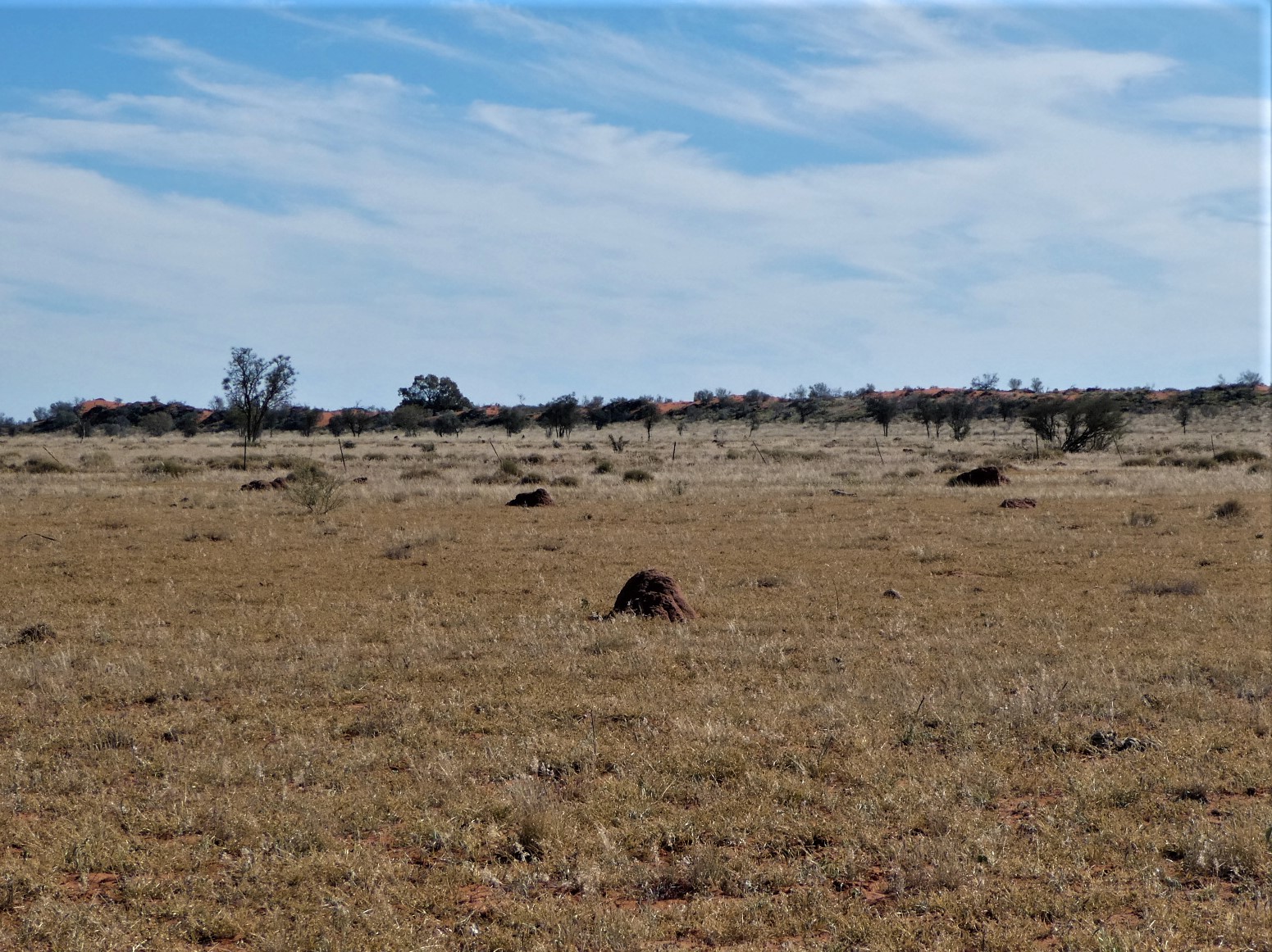
and Liz back on board after shutting the gate, we drove along the access track, from which we could see the long ridge of another dune beyond the termite mounds of this grazing paddock
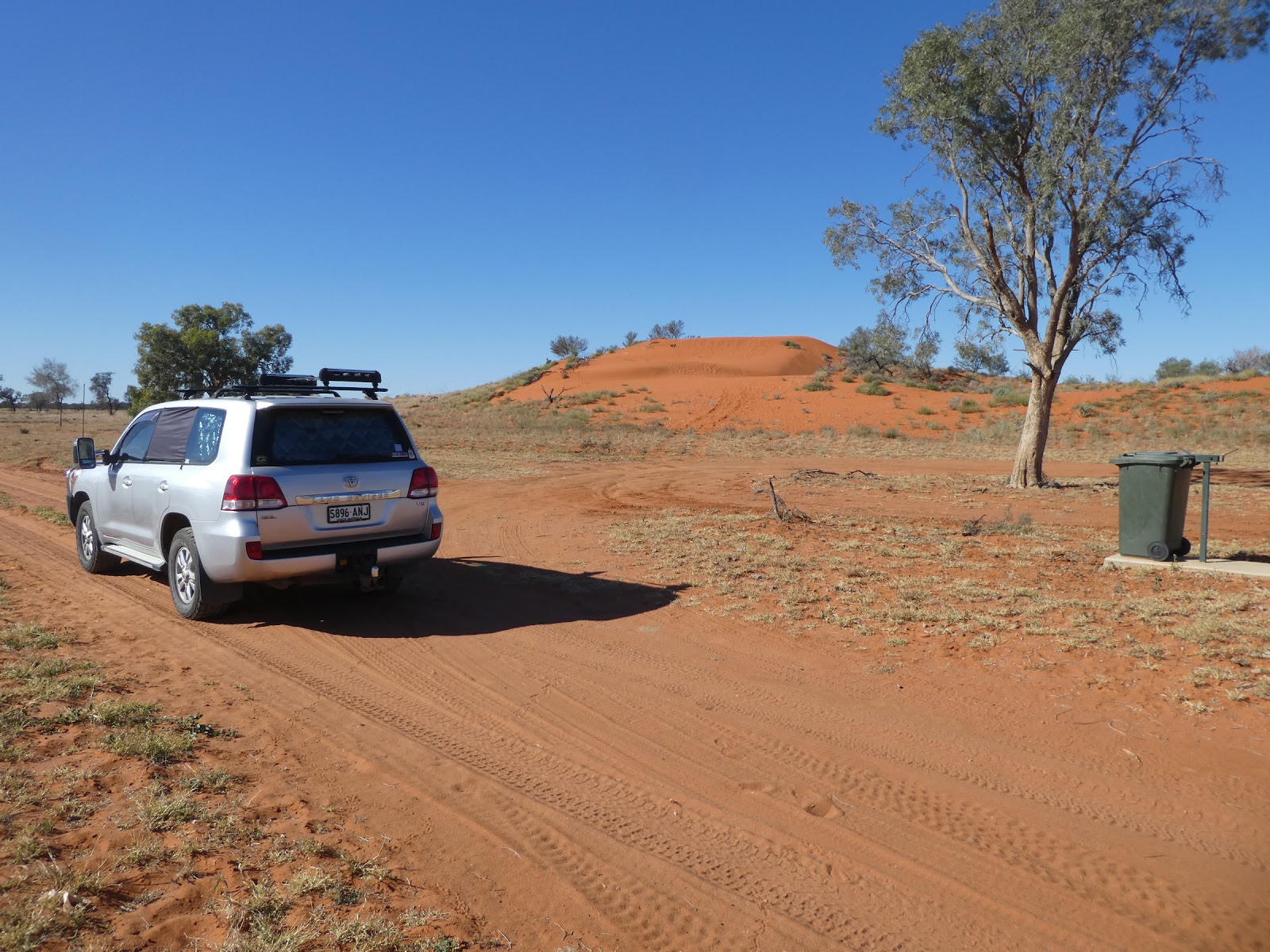
before we parked the cruiser in the parking area at the base of the hill we were about to climb.

So far so good, and now for the climb up what is, in the overall scheme of things, a modest dune, but one which does feature what is some of the reddest sand in Australia. The footprints of previous visitors covered the base of the hill,

but as we made our ascent, we were soon leaving our unique, but temporary mark on the sandy surface. As I looked back I was strongly reminded of that oft used adage found in National Parks and the like, "Leave nothing but footprints". We were doing just that,

as had a much smaller critter before us!

As we wandered around the summit of the first crest, the wind which creates these dunes was whipping across the top.....and it was bloody cold. Liz did her best to 'rug up'

whilst 'Mr Dag' cracked hearty and just grinned and bore it, snug in the thick shirt which had protected yours truly from the travails of Tassie temperatures!
Despite the fact that this hill is not as high as many, it was a fair haul through the sand to the top, but once there, the views over the surrounding plains made it well worth the effort.

Our transport below us seemed far off with the grazing plains stretching beyond.

From here we could also see the station homestead buildings off the west,

and to the north, the fences and tanks of a cattle yarding point.
At this point let me again resort to 'Google Earth' to show how this all fits. We we standing about where the green arrow ends.


This vantage point also brought us a great view of the effect of water through the channels, where this green swathe denotes the passage of the recent flood waters through the otherwise red and barren landscape.

From the eastern edge of the hill on which we were standing we could see across the intervening flat land to the ridge of the next similar sand hill, one of several between here and Windorah. Although we were quite some distance from the Simpson desert, this area did give us some idea of what we would find there, but with far less effort!
And so, as the title of this offering suggests, from the sand we move on to the water, but before we do so I must share another 'Google Earth' aerial shot with you.
This is the area about half way along the road back to Windorah which so clearly shows the lines of sand hills to the north of it

and to the south, the unbelievable network of channels on the flood plain, which was obviously dry when this photo was taken.
I had previously had trouble appreciating the fine filament like channel networks which become so obvious during the wet, as shown in this beautiful photo by 'Scott Bridle',

but the stretch alongside the Diamantina Development Road just west of Windorah would produce a result just like this during a flood. What an incredible area this is!
So now it is off to Cooper's Creek along the 12 kilometre track east of Windorah.

The large sign to our right heralded the beginning of the Nature Drive which would take us up to Cooper's Creek. All the relevant information stipulates the need for a high clearance vehicle, and although the track surface was relatively benign at the beginning we soon discovered that this was good advice.

Throughout this entire journey, which was to take us through ever changing landscapes, signs such as this identified the various trees and bushes we were passing,

whilst others identified various points of interest,

in this case the windmill, tanks and troughs of the 'Stock Route Water Point'.

The initial stages of the track took us across a flat, dry and somewhat barren landscape, but wow, how that was soon to change!

Not long after passing the very clearly signed private road entrance into a nearby station property

we came to a stock gate which, had it not been for a mud map we were carrying and the notice on the rails, we may have thought a bar to any further progress.

But we knew that this was part of the drive, and the good old gate girl was soon out and at it again for the second time today!

This 'tree trunk' pole once carried the single telephone line into Windorah in the days when shared lines through a central switchboard (which all on the network could access at any time) meant that conversations had to be carefully phased.....sledging the neighbours was a very risky practice in those days!

At about 5 kms into our trip we were still in gibber country where a bush I had seen on plenty of previous occasions was scattered across the open ground in numbers. I now knew it was turkey bush.
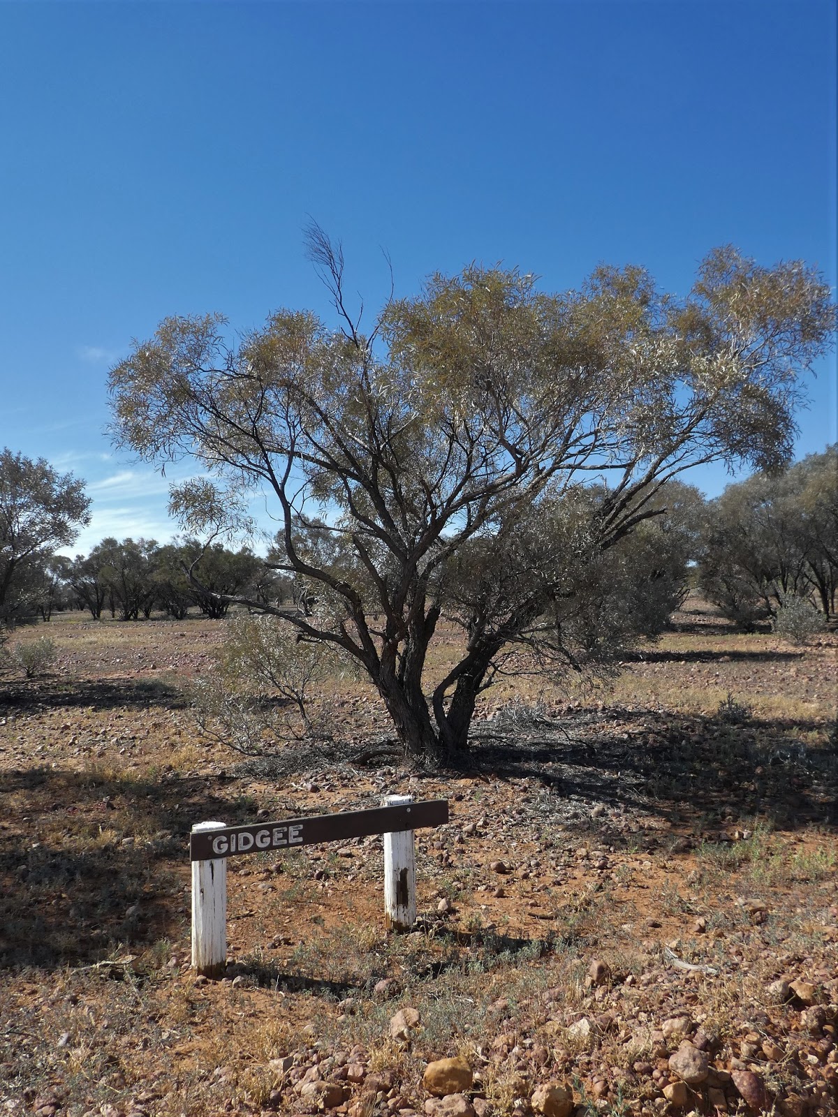
The Gidgee tree is reckoned to have the third hardest wood in the world. We know from previous experience that it burns hotly with little ash and is much valued as a camp fire timber. Unfortunately the leaves and bark, particularly those gathered around the base of the tree, give off a less than pleasant smell, reminiscent of boiled cabbage or sewerage. It is little wonder that it is known universally amongst those in the bush as the 'stinking wattle'.

We had barely passed the Gidgee tree when the country changed dramatically. The red earth gave way to that of a much darker colour and the hard gibbers had disappeared to be replaced by a carpet of green.

Deep ruts began to appear in the track as it snaked its way through the thickening grasses, clear evidence of the fact that this area had been very wet quite recently. We were beginning to see why high clearance vehicles were recommended for this drive.

Now all around us was lush and green. The grasses which spring up here after the rains or a flood are recognised as the best in Australia for cattle fattening. And here we had the added bonus of patches of wildflowers as well.

We soon found ourselves negotiating some sections of seriously damaged track. Sights like this make it easy to understand why so many outback roads are closed after heavy rain. Large vehicles leave deep, wide ruts which, once the mud dries, become rock hard obstructions to any trying to use the tracks. Here and there the grass was much higher,

and patches of different wildflowers began to appear, like these yellow button flowers

and these small daisies. If you look closely you may be able to see that the clay like ground in which these are growing is still scarred by the deep cracks of the dry.

As we got closer to Cooper's Creek the grass became higher and thicker. What a transformation the wet creates.

Dead Horse Creek lay between us and the end of the drive. The bed at the crossing point was thankfully dry,

but as I paused at the bottom of the quite steep incline,

it was clear looking upstream that when the water flows through here it does so at the rate of knots.

There was still quite a bit pooled downstream.

On the final run in to the Cooper's, the tall grasses again gave way to a much lower, thicker carpet

and the somewhat stunted trees of the dry plains, like the Gidgee, were replaced by the much more stately Coolibahs, but here there was nary a billabong or swaggie in sight!

Well, here we are, parked on the western bank of the iconic Cooper's Creek. I have waited years to see this and I was still having trouble believing I was finally here.

Cleared areas encourage free camping along these banks, and we spotted several lucky travellers taking advantage of this idyllic location.

Given the size of our current rig we would have a deal of difficulty accessing many of these river side sites, but camping on Cooper's Creek has gone directly into our 'to do' book for the time when we downsize and go off-road.

This really is a significant waterway (part of the second longest inland system in the country), but we did wonder how many years we would have to wait to see it quite like this again.

For our final stop before reaching the end of the Nature Drive we pulled in next to a table and bench seats under the shade of a stand of huge river red gums. What a marvellous camp site this would make. We were amazed that it was empty.

In other circumstances this certainly would have been our pick, in sight of the bridge between the trees, but today this was but the thing of future dreams!

From this vantage point we could see downstream to the remnants of the old crossing point used to ford the creek before the bridge was built.

Beyond the low stony barrier of the old crossing the far bank was crowded with pelicans, white necked herons and a lone egret. If any have doubts about the stories of the fish to be caught here, this was pretty good evidence that they are true.

From this point, looking upstream, the length of the bridge became more apparent, but what did really surprise me was what we could see moored below its eastern end.

A house boat, even one this small, was the last thing I expected to see here.

That brought us to the end of the Nature Drive, a most fascinating experience and one for which we are now great advocates.
But we were not quite finished with Cooper's Creek. We crossed the 'highway' (everything is relative out here!) and took a quick toddle along the track upstream of the bridge

where we found more happy campers (well, if they weren't they must be hard to please!)
During this trip, in several spots where the grass had grown so quickly it was already going to seed, flocks of these beautiful little birds rose in numbers I would estimate to be in the thousands.
I had read of this phenomenon, but could not believe the staggering numbers as these tiny birds rose to completely block out sections of the sky. They reminded me of huge shoals of bait fish as they swirled and twirled before settling on the grass stalks well ahead of us, only to rise again as we passed. I was more than miffed I had no hope of capturing this through the lens.

We ended this sojourn with another bridge crossing and a short descent to the creek's edge on the eastern bank. This proved a mistake on the part of yours truly,

because from here, between us and the old crossing, the sight of this boat trailer meant that some lucky bugger was out on the Cooper's catching callop or cod. My envy knew no bounds!
Being alongside Cooper's Creek not only fulfilled an ambition of mine long held, but brought with it the realisation that these scenes were all that I had imagined they would be. We shall return!
No comments:
Post a Comment