Sarina has been described as a 'compact town', with much of its community infrastructure in or close to Broad Street, its divided main street (which is actually the Bruce Highway as it runs almost north-south through the town).
Of this there is no doubt, and just as this town map shows, another major feature of Sarina's layout is that its streets wander about in all directions, partly due to the proximity of the ranges to the west and, I suspect, the fact that the initial growth of the town was centred on the sugar mill and the railway.

One advantage is that all of the CBD was within easy walking distance of our caravan park. For reference, I have marked its location with the red arrow, and that of the sugar mill and the nearby park, museum and information centre with the blue circle.
The major road on the left side of the map is that which brought us into town. The Bruce highway is self-evident, whilst the other major road running off the Bruce to the right of the map is the Sarina Beach Road which, as its name suggests, took us to the local beaches and to the huge coal loading port of Hay Point in nearby Dalrymple Bay. More of all this later.
The major road on the left side of the map is that which brought us into town. The Bruce highway is self-evident, whilst the other major road running off the Bruce to the right of the map is the Sarina Beach Road which, as its name suggests, took us to the local beaches and to the huge coal loading port of Hay Point in nearby Dalrymple Bay. More of all this later.

Like many 'sugar towns' (such as Tully, in particular), the mill dominates the Sarina skyline. Even if the structure itself is not visible, the plumes of steam and smoke which belch skywards from the various stacks can be seen for miles across the surrounding fields and forests.
Notwithstanding the prominence of the Sarina's sugar industry today, it was cattle grazing which initially brought settlers to this area in the mid to late 1800's. Runs were established around Plane Creek, the watercourse with runs through the southern end of the town.
Sugar was being grown, but it was not until government incentives allowed growers to band together and built a mill on Plane Creek in 1894 that the township began to expand.
Plane Creek, as the original settlement was known, was renamed Sarina in 1908. It took its name from that given to the nearby inlet by the surveyor William Borlase. Why he chose to christen that waterway after an enchantress of Greek mythology is anyone's guess. Certainly the reason for his choice has been lost in the mists of time.
Although cattle grazing continues throughout the area, sugar soon dominated the local economy and with more growers taking up land and the mill in full swing, Sarina was on its way. In 1913, the expanding the North Coast railway, which now connects the town directly to Brisbane, linked Sarina and Mackay.
Much later, in the 1970's, the development of the Hay Point coal terminal to service the ever expanding mining operations throughout the Bowen Basin to the east, provided a boost to the local economy, and the beaches south of the port soon became popular holiday destinations and retirement areas.
So as the title of this missive notes, Sarina is all about sugar, cattle and coal, but it is sugar which dominates.

It seemed reasonable to begin our town tour at the southern end of the town where, just north of the Plane Creek bridge, the steam stacks of the sugar mill tower over the town welcome sign.

This is not the largest mill in the State, but like all its counterparts, once the cane cutting is underway, the operations here run continuously 24 hours a day. When the wind was in the south, we could hear the constant hum from our park, but like all background noise, within a few days we hardly noticed it.
The somewhat cloying sugary smell was more of a problem, particularly for Liz who detests it, but fortunately instances of this were few and far between during our stay.
The Sarina mill is one of eight owned and operated in North Queensland by Wilmar Sugar. Last year it processed 1.7 million tonnes of cane which contributed to the company production of about half of Australia's total raw sugar.

But one thing which does make the Sarina mill different from others is its ethanol distillery, where molasses is converted to ethanol for industrial use and as a fuel.....to the tune of 60 million litres a year! As a by-product, this plant also produces a valuable fertiliser which is used in boosting cane growth. As we had learnt so many years ago in Tully, virtually nothing is wasted at any stage of the process of converting sugar cane to raw sugar.

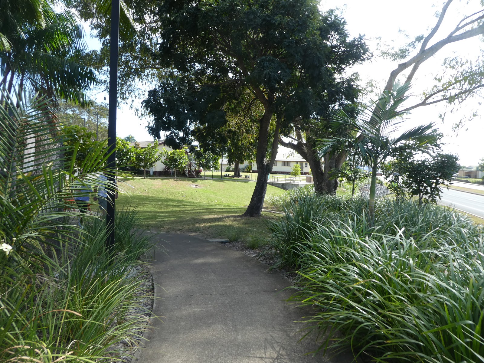
One of Sarina's major (and highly publicised) tourist attractions lies right on the mill's doorstep, a park area known as 'The Field Of Dreams'. Why? Frankly, when I read the explanation on the relevant website, I decided that I would be embarrassed to post it here....such schmaltz!!

At least what we actually found here was a damn sight better than the blurb explaining its name. Just past the mill buildings a footpath leads to........

.........all this.

Continuing along the path we first passed the huge Massey Ferguson cane harvester which is on display here. Having so often seen these monsters in the distance at work in the cane fields, it was quite interesting to actually be able to gain a good close up look at what is a remarkable piece of machinery.

The Sarina Sugar Shed proved to be exactly what we had expected,

a sophisticated commercial enterprise

which included a cafe,

and a sales outlet where all sorts of products were on offer. On top of all the usual souvenirs and clothing products, the Sugar Shed operates a small distillery and produces its own range of distinctive rums, schnapps and other liqueurs. Non alcoholic ginger beer and ice creams, gift hampers and a range of locally made relishes, sauces and chutneys also line the shelves and fill the freezers.
From here, too, guided tours of the mill are run on a regular basis throughout the day.
We were poor customers. We had already enjoyed a tour of the Tully mill a few years ago, we had no need of any clothing, souvenirs (Liz even resisted a stubbie holder!), relishes, coffee or cake, it was too early for ice cream, and rum is about the only spirit neither of us drink. Sorry folks, we are really here just to have a look!
Needless to say our Sugar Shed sojourn was short lived, and we were soon back on the path which would take us to the next section of this quite extensive park.


Seen here from the street, this group of buildings

includes the old Yukan railway station

includes the old Yukan railway station

and the Sarina museum, complete with this unusual piece of public art.

This cluster of old buildings, which houses the Sarina Arts & Crafts Centre, includes the original Court House built in 1906, the old town gaol, circa 1906, and the Mount Pelion School House (built in 1926).

The largest of all the buildings relocated here is the Regional Tourist Information Centre,

and as these shots show, the visitor season was in full swing. Those who arrived early had managed to find a parking spot....others were not so lucky.

We watched on with barely concealed amusement as those who arrived later circled about in various states of confusion, in many instances ignoring both directional arrows and common sense. Indeed as we stood here surveying the scene, a rather frazzled staff member from the centre emerged to try to bring a little order to this expansive parking lot.
She had only limited success and, in one disgraceful incident, was the subject of a real tirade from the female half of one clearly frustrated caravanning couple. This harridan was equally unamused when I quietly pointed out that they should learn to get up earlier!

'The Field of Dreams' is a singularly important part of the area tourist attractions and, as this shot, courtesy of 'Mackay City Centre' shows, it is a large complex, well positioned right next to the town mill.
Apart from all that can be seen and done here, the linear park which lines the highway presents a very attractive welcome to the town. It's just such a pity that the rationale which explains the choice of title for the area is such rubbish, but then again I suspect very few bother to dig it up as I have!

Anyway, it's time to move on, on north along the Bruce Highway, or, as it is known as it passes through the CBD, Broad Street. And broad it is indeed, with twin carriageways divided by a wide median strip.

Before reaching the main business area of the town, we passed the Sarina Leagues Club which is virtually opposite the Tourist Information Centre.
We did pop in briefly to see what was to be on offer here on the State of Origin night, and from what we saw this is a club which is well up to scratch. As it was we chose to stay in the park and yell for Queensland with others assembled at The Meeting Place.

Apart from the wide median strip, Sarina's main street could be anywhere. The three active town pubs

(these are two of them), the large bakery and a few other commercial odds and sods can be found on the western carriageway, whilst the other side of the road is home to the assortment of commercial enterprises which one would expect to find in a town of this size.

Central Street, which morphs into the Sarina Range Road (the one we used to come into town) is a clutter of various business including several medical practices. Looking west along it from Broad Street, it is easy to see just how close the edge of the range is to the town.

The town War Memorial, located on the median strip at this particular intersection, is one of two main items of interest to be found in Broad Street.

The other, some hundred metres or so further to the north, could not be more different. Here, with the garishly pink backdrop of the Sarina Hotel, 'Buffy' has pride of place.
We had previously seen (and obviously photographed) the spiel about Buffy at the Tourist Information Centre,

which saves me some typing time.

Seen here from the opposite direction, this now quite famous cane toad has his own specially constructed surrounds with explanatory plaques affixed to the walls. And as always happens during State of Origin, Buffy was dressed in a Queensland supporter's scarf on the day we wandered by.
This is by far the least of several indignities Buffy has had to endure in years gone by. He was actually painted with the Queensland colours on more than one occasion by over enthusiastic supporters, and has been stolen more than once. His position has now been made secure by chaining him to the concrete on which he sits.
One might well wonder why it is that a statue of this odious beast, one which has caused so much havoc across the country, occupies such a prominent position in Sarina.
Well Queenslanders, it seems, are a forgiving lot, and quick to latch onto anything which clearly sets them apart from the rest of Oz. As you may well have seen in the past, the flag we fly during SOO periods to support Queensland carries an image of a cane toad. In fact the team nickname is 'The Toads', but here in Sarina, Buffy represents the sugar cane industry on which the town relies so heavily.

This same industry is also the subject of several murals which adorn the walls of the public loo just beyond Buffy's patch.

As you can see from this shot, looking back south along the street from Buffy's patch, the median strip features many large shade trees which do much to beautify the entire central CBD.

A little further to the north, the town Post Office,

Court House and Police Station are all located at this end of Broad Street,

and by the time we reached the junction of Anzac Street, which leads up the hill to our caravan park, the median strip had come to an end. This large block of shops on the corner included one of real significance.....the 'chippo' which supplies the Friday fish feast at the park!

Beyond this point, the highway passes a number of civic buildings including the council chambers and library

as it continues north towards the Sarina Beach Road junction.We travelled along that road several times,

not least because it was here that we found one of the town's new major shopping areas which we visited more than once.
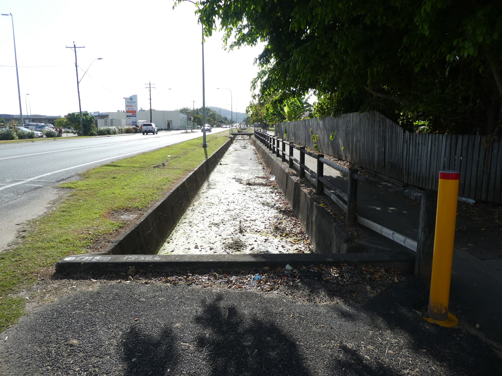
It was as dry as a chip during our two sojourns in Sarina, but as these gutters along the edge of the Sarina Beach Road attest, when it does rain here, it often pours!

It was also at this location we came across two of the most unusual houses we had ever seen.

Let me conclude this rather rambling town tour with a shot, on the high side of town, of the place we have both visited on previous occasions, the Sarina hospital

and a general view over some of the homes in this area with the ever present steaming and smoking stacks of the Sarina mill in the background.
As all the tourist information advocates, apart from the Sugar Shed and Field of Dreams, a visit to the nearby beaches and to the huge coal loading terminal at Hay Point should be on the 'must do' list of all who visit the town.
We did just that on several occasions.......coming to you in the next issue!
No comments:
Post a Comment