The 'King Jarrah' has done its bit to show off that species and we were impressed. Now it is time for the karris.....and we were more impressed!
We were off to explore the timber town of Pemberton, visit the south coast at Point D'Entrecasteaux (which shall be known for ever more in this missive as PDE) and Windy Harbour and take a drive through a karri forest or two.
Three 'tourist' karri trees were on our agenda....the 'Diamond Tree', the 'Gloucester Tree' and the 'Dave Evans Bi-Centennial Tree'. Our journey initially took us south out of Manjimup along the South-West Highway, where, 10 kms or so later, we turned off along the short entrance roadway to the car park at the 'Diamond Tree'.

There it was, our first giant karri, all 52 metres of it,

complete with its tree-top lookout, the box like structure you can see perched impossibly at the very top of the huge trunk.
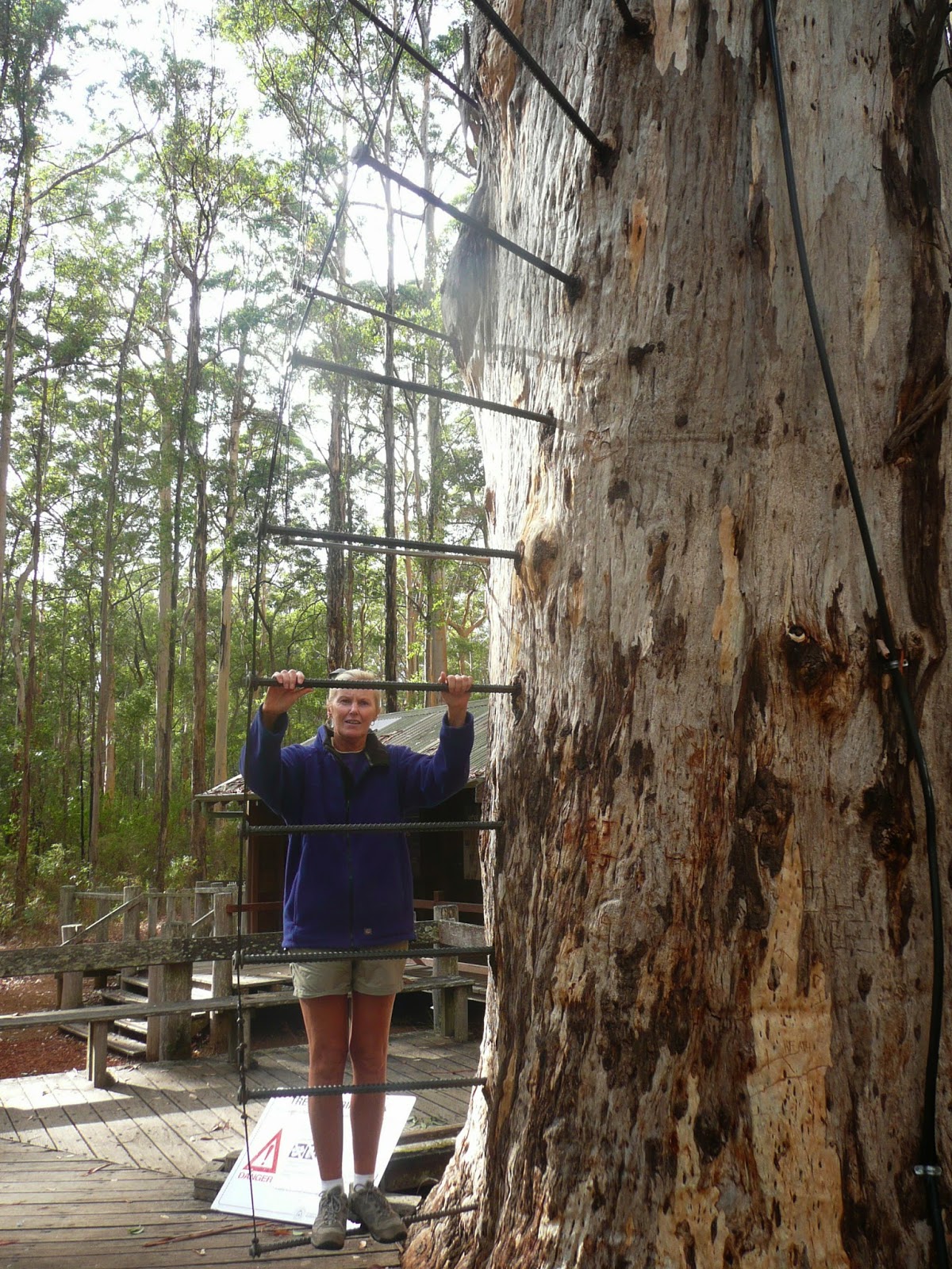
We had previously read that these trees are fitted with climbing steps and that the view from the top of them is nothing short of spectacular. I was abuzz with anticipation....until I saw what was actually on offer by way of 'steps'.....nothing more than long steel bars which spiralled upwards around the tree's trunk. The only safety device consisted of wire mesh netting which formed a kind of tube at the back of any climbers. This, I decided would do absolutely nothing to prevent a very nasty fall if one slipped during ascent or descent.

I was even less encouraged to scale the heights after reading the nearby advisory sign which cautioned against attempting an ascent if "unfit, have a heart condition or are afraid of heights". The heart's OK, but dicky knees would probably rate as an impediment and, despite all my leaps from hovering helicopters, heights are not really my thing. Not promising so far.
The sign also notes that "space is limited on the pegs and part of the climb is near vertical. Please be considerate of other climbers when passing". When passing.....ye gods I hadn't event thought of that possibility!
The sign also sagely informed prospective adventurers that the pegs became slippery when wet (really!!) and that windy or stormy weather conditions were not ideal for a climb. No argument with any of that, but the bit that really grabbed my attention was the advocation that there should never be more than nine persons in the lookout at any one time. Just how one would know how many Jack and the Beanstalk types were standing proudly atop the tree before one's ascent began I have no way of knowing. "Hello up there...coming up...please number off so I can climb with confidence...I have no wish to be double figures!!"
Oddly enough, we left the Diamond Tree without being able to tick off the box 'Views across the forest' and made our way onto the Vasse Highway en route to Pemberton

The road took us past the first of a number of vineyards and orchards we were to see that day. By the end of this tour we had no difficulty in accepting the fact that this area does indeed grow more grapes than Margaret River.

Another much advertised product of the Pemberton district is marron. We were reminded of this as we passed this commercial marron pond on the outskirts of the town. I did later make purchase enquiries at a Pemberton marron outlet only to find that they were more expensive than crayfish....bugger!

Pemberton is a pretty little town nestled in a valley surrounded by the Gloucester National Park. According to the tourist blurb, "with its cool Mediterranean climate, crystal clear streams and rich earth, the scenic diversity of Pemberton is awe-inspiring". A bit effusive, but not too far off the mark.

The predominant feature of Pemberton's main street is a delightful park which occupies a considerable distance of one side of it. Flowering trees,

flower beds and autumn leaves of this time of the year all provide a real splash of colour

and a lovely setting for the local RSL building and the nearby remembrance memorial area. And, of course, more brown stone walls!

One thing Pemberton does not do well is cater for the travelling public. On the day of our visit, the local bakery was closed. We did poke an enquiring nose into the rather up-market cafe opposite, only to have confirmed what we suspected from what we had read about it. Fine luncheon fare indeed was on offer, such as, for example a platter of marron, chorizo, cheeses and breads and assorted accompaniments...a mere $80! And all else on the menu was of the same ilk....all we wanted was a toasted sandwich.

The rather grand looking Pemberton pub did rate some dining consideration, but we were on a pretty tight schedule which did not really include a long, leisurely lunch. We ended up munching on a Mrs Macs pie from the local general purpose store....there goes my pastry allowance for the next fortnight!
Whatever Pemberton may lack in the catering department, it more than compensates when it comes to forest. The second on our list of big, climbing trees was nearby....The 'Gloucester Tree'.


By now we had learnt that these special trees were not immediately evident on approach, given the size of their neighbours. The Gloucester Tree was no exception and was only really identifiable at this point by virtue of the fact that the pathway lead directly to it.
This 61 metre whopper boast not one, but two lookouts. For those clambering their way skywards,

a mid-way platform offers the opportunity to take in preliminary views across the park (read excuse for a breather!) before a relatively benign staircase is used to complete the accent.

But don't be fooled.....the bottom section remains spiralling steel pegs.
As much as seeing this 'tourist' tree, we were here to take our first jaunt through a karri forest. I have already banged on about the effect this had on me, so I'll not dwell other than to repeat that these are stunning places.
Although we chose one of the shorter of the various tracks available, we were not disappointed in the slightest with what we saw.

If you look closely, you will see Liz in her blue top coat on the pathway.....I hope this presents some idea of the height of these trees and the grandeur of the forest generally (and at this point the trees were fairly well spaced).
Before we go further, a quick word about the karri. This species of eucalypt, which can grow to a height of 85 - 90 metres, is beaten only by the Mountain Ash of Victoria and Tasmania (add another 10 metres or so) as the tallest in the country. It is found only in the rich brown loam soils of the incised valleys of the extreme south of Western Australia between Cape Leeuwin and Albany. Here the high rainfall provides for the 170 litres of water these trees suck up out of the ground per day. To reach the tops of mature trees from the ground so far below, this water is transported up through the bark at the extraordinary pressure of 300 lbs per square inch, a feat which remains a scientific mystery.
Bark drop, as we shall see later, is a feature of the karri. A forest of these trees can produce three tonnes of bark litter per hectare per year, which, if left uncleared (forest fires are very useful in a karri forest) would mean anyone trying to walk through it would be waist deep in litter.
Early settlers to this region noted the fact that the karri grew in patches (where the soil is right) and made a fundamental agricultural error. They cleared tracts of trees in the mistaken hope that other plants would do equally well, only to find that they failed dismally....the karri is indeed the master of its environment.

Our short walk through the Gloucester National Park took us past a few burnt trees,

the odd felled trunk or two

and the occasional reminder of the results of the logging industry prior to the preservation of this area as a national park.

I referred previously to the penchant of the karri to drop its bark. Looking around the base of this fellow, which was in the process of shedding, you can gain some idea of the volume of litter one tree contributes to the forest floor.

Apart from resulting in the light golden colour of the new bark layer, which means that karri trees in the sunlight appear particularly striking, this shedding process can also result in intricate bark patterns of constant variety. If you hadn't guessed by now, dear reader, I've become a huge fan of this gift of nature to the southern part of WA.
It was with some reluctance, and with an eye to our day's schedule which could best be described as full, that we left the forest and again took to the bitumen.

Our 65 kms journey from Pemberton, through the small town of Northcliffe to the coast at Windy Harbour, took us through patches of tall forest where the soil and growing conditions were favourable

before this gave way to the low scrub of the sandy coastal region.
And here, at PDE, a whole new vista lay before us, one of comparable grandeur to that of the karri forests...the rugged coastal cliffs, small offshore islands and shoals and the weathered basalt pinnacles of this part of the south coast.

We first took in the long sandy surf beach known as Salmon Beach, here looking to the north-west from our vantage point.

In the opposite direction the beach came to an abrupt halt at the base of the headland cliff which is in fact the western end of the jutting land peak which is PDE.

From Salmon Beach we made our way past the weathered 'pinacles' landscape

and onto the pathway to the first of two established clifftop lookouts on PDE.
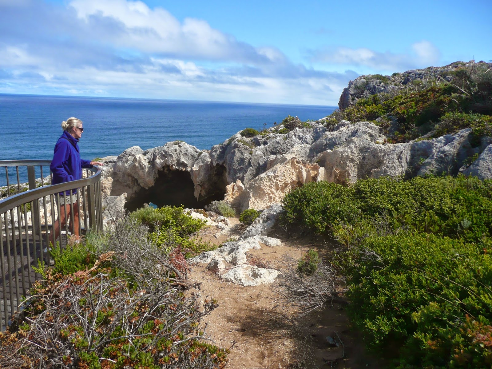
From this angle things look relatively innocuous, as I thought on my approach.

That Innocent thought lasted just as long as it took me to reach the lookout platform and peer over.....whoof!! The benign looking dark blob in the previous shot is actually the shadow of the interior of this extraordinary hole in the rock of the cliff face, through which the surf could be seen thundering against the rocks at least 150 metres below where we were standing. Whoof again!! What a treat for the vertigo sufferer. This photo was taken with a very firm grip on the rail with the other hand!

A step back from the rail and lifted eyes revealed the sheer ruggedness of the cliffs of this area. It reminded us both of our Nullarbor crossing so many months ago.

A second platform further around the point provided a vantage point from which to look out over the Southern Ocean
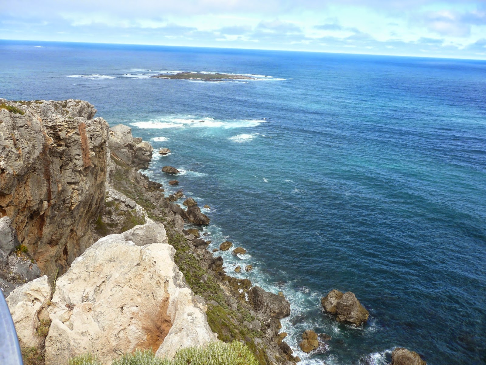
and along the cliffs of the head of the point which I again estimated to be at least 100 metres plus high.

The coast in the opposite direction was equally rugged....this was pretty spectacular stuff indeed!
The pathway back to the parking lot brought us views to the east from the point of the flat coastal hinterland and the distant rooftops of the hamlet of Windy Harbour.

That was our next destination. And what an interesting little spot this proved to be where

relatively modern beach houses and areas of green lawn

happily rubbed shoulders with dry and dusty roadways and real shacks,

including this one rather grandly named 'Seagulls Call'. I'll bet they do.
Our real purpose in coming to Windy Harbour was to check out the caravan park. It had been recommended to us, but for some reason I had remained a little sceptical, especially in light of what we had found previously at Peaceful Bay compared with its publicity.

I was pleasantly surprised with what we found. The park here looked quite good. We suspect that water is very limited, and there were few trees to provide shade or break up the wind, but at least there was plenty of grass.

The park office was a touch rustic to say the least but from what we could see seemed to be able to provide the essentials. This is clearly a fishing hamlet in which a few folk live full time but which I am sure is absolutely wall to wall during the major summer holiday periods. As we drove around the village I had visions of the road dust which I am sure would be a permanent feature here when things were busy. Windy Harbour was off the list for next year.

This decision was supported by the fact that, as we are beginning to find on this part of the WA coast, the 'swimming beach' is little more that a paddling stretch between rocks.

Windy harbour does sport a very impressive boat park and volunteer sea rescue shed

and it was obvious to us that fishing, both inshore and offshore, is very much the reason for spending time at Windy Harbour, but interestingly my initial assessment of the boat ramp, which ends in thick sand

was more that justified when I read this nearby sign. Boating at Windy Harbour has the potential to be a real adventure!
It was time to head back to Manjimup and Fonty's Pool. Not far from Windy Harbour we passed Mt Chudalup, a huge granite monolith which rises out of the karri forest and coastal heath to a height of 187 metres.

A climb to the top of this solid lump is guaranteed to provide the adventurous with a wonderful view over the surrounding landscape, including the massive Yeagarup inland sand dunes off to the west. We had neither the time or real inclination at this point in our day but I was curious to discover what we had missed. The Internet can be a marvellous thing. This is the view we denied ourselves.

The last of the big trees was now firmly in our sights. The 'Dave Evans Bi-Centennial Tree' stands in the Warren National Park a few kilometres south-west of Pemberton.

This whopper is the king of the castle when it comes to 'the big three karris'....it towers 75 metres above the forest floor,

and like the others, offers peg steps and a treetop viewing platform to the intrepid, one of whom I caught just as he was about to clamber onto the deck. But, unlike its fellows, this tree's viewing platform was not built as a fire spotting lookout. As its name suggests, it was constructed as part of Australia's 200 year anniversary celebrations. And Dave Evans?....a local luminary who had contributed much to the community.

As you may have gathered by the length of this blog, we were having a big day out! The last leg was at hand, a drive back to Fonty's along the quaintly named Cherrybearup Road which gave us our last look at karri forest for the day.

As we neared Manjimup, the tracts of forest gave way to avocado orchards,

and rows of sweet corn against a backdrop of a hillside vineyard

until this now familiar sign came into view. It had been a long day indeed. But we felt by now we had largely come to grips with what is on offer in the Southern Forests. There remains a deal to see in this area, but that will just have to wait for another visit.
happily rubbed shoulders with dry and dusty roadways and real shacks,
including this one rather grandly named 'Seagulls Call'. I'll bet they do.
Our real purpose in coming to Windy Harbour was to check out the caravan park. It had been recommended to us, but for some reason I had remained a little sceptical, especially in light of what we had found previously at Peaceful Bay compared with its publicity.
I was pleasantly surprised with what we found. The park here looked quite good. We suspect that water is very limited, and there were few trees to provide shade or break up the wind, but at least there was plenty of grass.
The park office was a touch rustic to say the least but from what we could see seemed to be able to provide the essentials. This is clearly a fishing hamlet in which a few folk live full time but which I am sure is absolutely wall to wall during the major summer holiday periods. As we drove around the village I had visions of the road dust which I am sure would be a permanent feature here when things were busy. Windy Harbour was off the list for next year.
This decision was supported by the fact that, as we are beginning to find on this part of the WA coast, the 'swimming beach' is little more that a paddling stretch between rocks.
Windy harbour does sport a very impressive boat park and volunteer sea rescue shed
and it was obvious to us that fishing, both inshore and offshore, is very much the reason for spending time at Windy Harbour, but interestingly my initial assessment of the boat ramp, which ends in thick sand
was more that justified when I read this nearby sign. Boating at Windy Harbour has the potential to be a real adventure!
It was time to head back to Manjimup and Fonty's Pool. Not far from Windy Harbour we passed Mt Chudalup, a huge granite monolith which rises out of the karri forest and coastal heath to a height of 187 metres.
A climb to the top of this solid lump is guaranteed to provide the adventurous with a wonderful view over the surrounding landscape, including the massive Yeagarup inland sand dunes off to the west. We had neither the time or real inclination at this point in our day but I was curious to discover what we had missed. The Internet can be a marvellous thing. This is the view we denied ourselves.
The last of the big trees was now firmly in our sights. The 'Dave Evans Bi-Centennial Tree' stands in the Warren National Park a few kilometres south-west of Pemberton.
This whopper is the king of the castle when it comes to 'the big three karris'....it towers 75 metres above the forest floor,
and like the others, offers peg steps and a treetop viewing platform to the intrepid, one of whom I caught just as he was about to clamber onto the deck. But, unlike its fellows, this tree's viewing platform was not built as a fire spotting lookout. As its name suggests, it was constructed as part of Australia's 200 year anniversary celebrations. And Dave Evans?....a local luminary who had contributed much to the community.
As you may have gathered by the length of this blog, we were having a big day out! The last leg was at hand, a drive back to Fonty's along the quaintly named Cherrybearup Road which gave us our last look at karri forest for the day.
As we neared Manjimup, the tracts of forest gave way to avocado orchards,
and rows of sweet corn against a backdrop of a hillside vineyard
until this now familiar sign came into view. It had been a long day indeed. But we felt by now we had largely come to grips with what is on offer in the Southern Forests. There remains a deal to see in this area, but that will just have to wait for another visit.
In our final tourist cast around Manjimup, I take a look at the local orchards and find out all about that epicurean delicacy which is produced here.....the black truffle.
No comments:
Post a Comment