Will we ever come to grips with the numbers? Those associated with the iron ore industry with which we were becoming familiar defy belief. What we found in Dampier was no exception. And after our introduction to the world of massive salt production in Onslow, here we find it again.
But before we take a fleeting (all that we could see) look at what Rio Tinto gets up to in this town, a quick roam around the rest of it is in order.

But before we take a fleeting (all that we could see) look at what Rio Tinto gets up to in this town, a quick roam around the rest of it is in order.
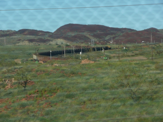
What a fitting introductory sight we saw as the road into Dampier climbed up and over the ore train railway bridge on the edge of town.....one of the massive trains on its return journey from the port to Tom Price with the red hills of the Pilbara in the background.

At the nearby Dampier Information Bay visitors to the town are greeted by none other than 'Red Dog', (well in a bronze reincarnation at least) that legendary kelpie/cattle dog cross which roamed the Pilbara for years after the death of his second master, hitching rides on ore trains, in buses, utes and cars, and any other form of transport which would carry him. It is said he even made it all the way to Adelaide and back again.
Sadly this most convivial canine met his end after eating a poisoned bait.....it is as well for the person who laid it that their identity has never been discovered. Had it become known I strongly suspect the term 'summary justice' would have become a reality!

As we drove beyond the information bay towards the town lookout area which provides views over the water, we passed one of many of these barrack style buildings which dot the town. Most appeared deserted and we assumed they had been used to quarter the single members of the original town workforce.

Dampier looks out over what is essentially a channel between the shoreline and the large salt loading facility offshore.

Panning further to the right we could see more of the channel, the land mass beyond it and the roof line of another of the accommodation blocks beyond the jumble of red Pilbara rocks which are also another feature of the town.

Focusing in across the water, the huge salt stockpiles come into view. This is the product of the massive salt pans on the outskirts of Karratha which we passed on our way to Dampier.
This seems an opportune point to have a quick look at the scale of this operation. Dampier Salt, a Rio Tinto owned company, is the world's largest exporter of salt. It owns and operates three facilities in WA, at Lake McLeod just north of Carnarvon, here at Karratha and further north at Port Headland.

In an attempt to make some sense of how this all works I have taken the unusual step of reproducing this map in 'extra large'. We were standing at the spot indicated looking out over one of the brine ponds. The green area towards the top of the map is the Dampier township. If you look closely to the left of that you will see two white patches connected by a straight line. These are the salt stockpiles on the Dampier loading causeway. That which appears in the middle is the one pictured in the previous photo.

And this is but one of the evaporation pans we could see from the information lookout point near Karratha, one of many.

The water channels which fill these pans run along both sides of the main highway leading out of Karratha to Dampier and the Burrup Peninsula.

Driving out along it we found that someone in the company has a real sense of humour. At several points we saw this sort of thing....here we had two dummies lounging alongside a BBQ and a couple of cartons of beer with the caption reading 'Living the Dream'. What a hoot!

And another example. I am a little surprised (but also very pleased) that these have been tolerated by the local authorities...we were not the only vehicle to slow on this very busy road to ogle.

But back to business. This photo, courtesy of 'australiaforeveryone.com', shows just how the salt loading works at Dampier. The harvested salt is trucked to the coast, carried by conveyor belt across the purpose built causeway to the first stockpile (as seen in my previous photo) thence to the loading pile on Mistaken Island and finally onto the bulk carrier.
Tonnes and tonnes of it leave here each year. Some final figures for your enlightenment and entertainment (or complete boredom...it's up to you). It takes 65 tonnes of sea water to produce 1 tonne of salt. In their Karratha operation, Dampier Salt floods over 11,000 hectares of evaporation and crystallising pans. During winter the average evaporation rate is 420,000 tonnes of water per day. This rises to an astonishing 1,000,000 tonnes per day during summer.
One hundred and twelve kilometres of roads,levees and conveyor belts have been built to support the operation. The bulk carriers are loaded at the rate of 2,800 tonnes per hour. And the total export tonnage per year.....4,200,000 tonnes of the stuff! This is big business with a capital 'B'!

After all this mind blowing stuff, let's get back to the business of our tour of Dampier. From our vantage point at the William Dampier lookout, we drove down towards the Esplanade,

past the bowls club and, could you guess, the associated Chinese Restaurant (we thought for a moment we were back on the east coast!)

to a spot where we could look out over another jumble of red rocks across the local soccer field to the beach beyond.

We were less than surprised to find that the Dampier soccer lads have taken advantage of the canine legend of the Pilbara as their club name.

The clubhouse sits alongside a small palm lined park

and from its front steps we could take in the public BBQ and picnic area on the shoreline at this southern end of the town.

Here is another example of the difficulty I often have with the tourist blurb and reality. This stretch of course sand and interspersed rocks to the south of the park

and in the other direction, are touted in one brochure as being 'white, sandy beaches' on which to laze away a day or two. I don't think so!
It was here that we came across one of the quaintest of War Memorials we had ever seen.....two flagpoles set in the beach with a pile of sandbags (presumably) representing a fortified position between them.

I am still not quite sure what to make of this. It is nothing if not simple, and I guess it is better than nothing at all......but, frankly, only just.

Further along the Esplanade to the north of the beachfront park is the rather grand (for Dampier, that is) building of the Hampton Harbour Boat and Sailing Club.

This is a pretty exclusive joint. To get this shot of the front of the club I had to sneak down a path which I suspected was for members only, but what the hell, nothing ventured and all that. I was a visitor on a mission.

The associated boat launching area is fenced and gated.

Odd I thought, until I read this sign on one of the gates. No wonder access here is somewhat restricted. What I could not understand is why all this security exists here when, not too far along the seafront (as we shall see shortly) there is another large public launching facility with no restrictions of any kind. This remains a mystery.

But having possibly been a very naughty boy, I did take advantage of the position to get this shot back south along the seafront to the distant palms of the soccer club and picnic area

and north, where I had my first glimpse of the iron ore loading facility at Parker Point.
Dampier is a mining town, of that there is no question. And here I shall be lazy again by quoting directly from the Pilbara Coast Holiday Planner, produced by the City of Karratha.
"Named after William Dampier who explored the North West Coast in 1699, Dampier is located 21 kms north-west of Karratha, overlooking the ocean and the islands of the Dampier Archipelago. The Port of Dampier was developed in 1963 when Hammersley Iron entered into an agreement with the state government to develop an iron ore mine at Tom Price and a port in the Burrup Archipelago which would allow the company to export its iron ore to world markets. The town has a population of approximately 1,250 people."
Dampier is now surrounded by approximately 11,000 hectares of industrial land - the Woodside operated North West Shelf Venture's Karratha Gas Plant, Woodside's Pluto Gas Plant, and Rio Tinto's Iron Ore and Salt operations. Dampier is Australia's highest value port, with exports of $34 billion (28 percent) of Western Australia's merchandise exports, and the second highest volume port. Dampier is also home to the King Bay Supply Base which provides important support to the offshore oil and gas industry."
This is all pretty heady stuff. Another set of numbers which I found mind numbing.

As we pushed on along the Esplanade towards Parker Point we came to the public boat ramp, the size and construction of which showed two things. Recreational boating and fishing in this part of the world is almost mandatory,

and here the tides are whoppers, not quite that of Derby as we were to see later, but still of sufficient variation to warrant very long launching platforms.

It was here that we found the Dampier Caravan Park, one we had contemplated visiting for a couple of days. It is well maintained but we decided our decision to spend the entire time at Point Samson had been wise....the sites here were small and there is a distinct limit to what one can do as a visitor in Dampier.

Sport is vital to the social life of most of these smallish towns, and Dampier is obviously no exception. The main town oval and sports club buildings were expansive and well watered.

The buildings of the Rio Tinto Training Centre are to be found nearby, set in a very neat garden fringed by palms.

This is very much the business end of town. As we approached the northern end of the seafront, all local amenity gave way to the real purpose of all this....iron ore exports.

This facility is not quite on the same scale as that at Cape Lambert, but it is no slouch nevertheless.
As I said before, we were unable to gain any really good shots of the port. I am therefore indebted to peterbellingham.com for providing this excellent overview of the Parker Point ore loading wharf and the four bulk carriers alongside.

The current size of operations here is the result of a relatively recent expansion, which leads me to regale you with a few more staggering numbers. Parker Point began operations as a single berth serviced by one ore loader. In 2007 what we now see was completed......room for four ships at a time serviced by two loaders. This upgrade took three years to complete, involved over 5 million man-hours of work and, wait for it, cost a mere $2 billion, yes billion. ($2,000,000,000) As we were rapidly learning, when it comes to development costs in the iron ore mining industry, think of a number and then just keep adding 0's!

All that now remained was to have a quick look at some of Dampier's housing and the CBD. Even as we climbed up from the Esplanade, these odd shaped power poles were yet another reminder of the fact that this is a town with a purpose.

Dampier is quite hilly, and where ever we drove a consistent feature of the street scape

were jumbled piles of Pilbara red rock in vacant land areas between streets and houses....open space Dampier style.

Most of the Dampier housing is what I would describe as unpretentious, but consistent with all we had previously seen to date in towns such as this, large boats were to be found in most driveways, or in many cases, on the front verge....they were too big to fit anywhere else.

Dampier is not the town to visit if the need for a wide ranging shopping spree is high on the agenda. With Karratha being so close, there is no point in establishing commercial ventures beyond the basics. An IGA supermarket, a coffee shop and a few other small stores make up the compliment.

The parking quadrangle is bounded on the one side by the supermarket etc, and on the other, the quite large Dampier Hotel, on which a large sign

may gives some hint as to the social norms of a goodly proportion of the town's population.

I was somewhat amused to find the Dampier Police Station at the head of the quadrangle. It almost shares a common wall with the hotel....how practical in the case of a pub brawl...walk out of one door and into the the next, and then reverse the process, miscreants in tow.! No need for a 'paddy wagon' here.
For us, this was Dampier. It was time to move on to the nearby North-West Shelf Project visitor centre, not too far away north along the Burrup Peninsula.
As we left Dampier, we did pause briefly on the purpose built viewing platform to take one last look at yet another massive Pilbara iron ore train as it shunted its 200 or so waggons
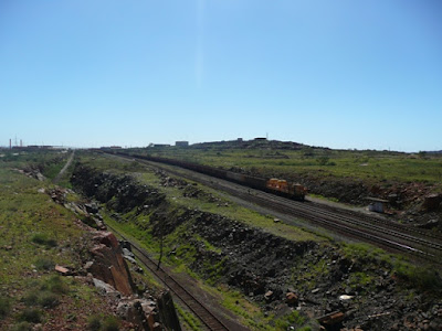
into Parker Point for loading. It was fascinating to listen to the clanking and creaking of the couplings roll along the length of the train as they took up as successive sets of waggons were positioned over the receiving hoppers.
So much for salt and iron ore....now for gas. Could our minds cope with another round of staggering figures?

At the nearby Dampier Information Bay visitors to the town are greeted by none other than 'Red Dog', (well in a bronze reincarnation at least) that legendary kelpie/cattle dog cross which roamed the Pilbara for years after the death of his second master, hitching rides on ore trains, in buses, utes and cars, and any other form of transport which would carry him. It is said he even made it all the way to Adelaide and back again.
Sadly this most convivial canine met his end after eating a poisoned bait.....it is as well for the person who laid it that their identity has never been discovered. Had it become known I strongly suspect the term 'summary justice' would have become a reality!

As we drove beyond the information bay towards the town lookout area which provides views over the water, we passed one of many of these barrack style buildings which dot the town. Most appeared deserted and we assumed they had been used to quarter the single members of the original town workforce.

Dampier looks out over what is essentially a channel between the shoreline and the large salt loading facility offshore.

Panning further to the right we could see more of the channel, the land mass beyond it and the roof line of another of the accommodation blocks beyond the jumble of red Pilbara rocks which are also another feature of the town.

Focusing in across the water, the huge salt stockpiles come into view. This is the product of the massive salt pans on the outskirts of Karratha which we passed on our way to Dampier.
This seems an opportune point to have a quick look at the scale of this operation. Dampier Salt, a Rio Tinto owned company, is the world's largest exporter of salt. It owns and operates three facilities in WA, at Lake McLeod just north of Carnarvon, here at Karratha and further north at Port Headland.

In an attempt to make some sense of how this all works I have taken the unusual step of reproducing this map in 'extra large'. We were standing at the spot indicated looking out over one of the brine ponds. The green area towards the top of the map is the Dampier township. If you look closely to the left of that you will see two white patches connected by a straight line. These are the salt stockpiles on the Dampier loading causeway. That which appears in the middle is the one pictured in the previous photo.

And this is but one of the evaporation pans we could see from the information lookout point near Karratha, one of many.

The water channels which fill these pans run along both sides of the main highway leading out of Karratha to Dampier and the Burrup Peninsula.

Driving out along it we found that someone in the company has a real sense of humour. At several points we saw this sort of thing....here we had two dummies lounging alongside a BBQ and a couple of cartons of beer with the caption reading 'Living the Dream'. What a hoot!

And another example. I am a little surprised (but also very pleased) that these have been tolerated by the local authorities...we were not the only vehicle to slow on this very busy road to ogle.
But back to business. This photo, courtesy of 'australiaforeveryone.com', shows just how the salt loading works at Dampier. The harvested salt is trucked to the coast, carried by conveyor belt across the purpose built causeway to the first stockpile (as seen in my previous photo) thence to the loading pile on Mistaken Island and finally onto the bulk carrier.
Tonnes and tonnes of it leave here each year. Some final figures for your enlightenment and entertainment (or complete boredom...it's up to you). It takes 65 tonnes of sea water to produce 1 tonne of salt. In their Karratha operation, Dampier Salt floods over 11,000 hectares of evaporation and crystallising pans. During winter the average evaporation rate is 420,000 tonnes of water per day. This rises to an astonishing 1,000,000 tonnes per day during summer.
One hundred and twelve kilometres of roads,levees and conveyor belts have been built to support the operation. The bulk carriers are loaded at the rate of 2,800 tonnes per hour. And the total export tonnage per year.....4,200,000 tonnes of the stuff! This is big business with a capital 'B'!

After all this mind blowing stuff, let's get back to the business of our tour of Dampier. From our vantage point at the William Dampier lookout, we drove down towards the Esplanade,

past the bowls club and, could you guess, the associated Chinese Restaurant (we thought for a moment we were back on the east coast!)

to a spot where we could look out over another jumble of red rocks across the local soccer field to the beach beyond.

We were less than surprised to find that the Dampier soccer lads have taken advantage of the canine legend of the Pilbara as their club name.

The clubhouse sits alongside a small palm lined park

and from its front steps we could take in the public BBQ and picnic area on the shoreline at this southern end of the town.

Here is another example of the difficulty I often have with the tourist blurb and reality. This stretch of course sand and interspersed rocks to the south of the park

and in the other direction, are touted in one brochure as being 'white, sandy beaches' on which to laze away a day or two. I don't think so!
It was here that we came across one of the quaintest of War Memorials we had ever seen.....two flagpoles set in the beach with a pile of sandbags (presumably) representing a fortified position between them.

I am still not quite sure what to make of this. It is nothing if not simple, and I guess it is better than nothing at all......but, frankly, only just.

Further along the Esplanade to the north of the beachfront park is the rather grand (for Dampier, that is) building of the Hampton Harbour Boat and Sailing Club.

This is a pretty exclusive joint. To get this shot of the front of the club I had to sneak down a path which I suspected was for members only, but what the hell, nothing ventured and all that. I was a visitor on a mission.

The associated boat launching area is fenced and gated.

Odd I thought, until I read this sign on one of the gates. No wonder access here is somewhat restricted. What I could not understand is why all this security exists here when, not too far along the seafront (as we shall see shortly) there is another large public launching facility with no restrictions of any kind. This remains a mystery.

But having possibly been a very naughty boy, I did take advantage of the position to get this shot back south along the seafront to the distant palms of the soccer club and picnic area

and north, where I had my first glimpse of the iron ore loading facility at Parker Point.
Dampier is a mining town, of that there is no question. And here I shall be lazy again by quoting directly from the Pilbara Coast Holiday Planner, produced by the City of Karratha.
"Named after William Dampier who explored the North West Coast in 1699, Dampier is located 21 kms north-west of Karratha, overlooking the ocean and the islands of the Dampier Archipelago. The Port of Dampier was developed in 1963 when Hammersley Iron entered into an agreement with the state government to develop an iron ore mine at Tom Price and a port in the Burrup Archipelago which would allow the company to export its iron ore to world markets. The town has a population of approximately 1,250 people."
Dampier is now surrounded by approximately 11,000 hectares of industrial land - the Woodside operated North West Shelf Venture's Karratha Gas Plant, Woodside's Pluto Gas Plant, and Rio Tinto's Iron Ore and Salt operations. Dampier is Australia's highest value port, with exports of $34 billion (28 percent) of Western Australia's merchandise exports, and the second highest volume port. Dampier is also home to the King Bay Supply Base which provides important support to the offshore oil and gas industry."
This is all pretty heady stuff. Another set of numbers which I found mind numbing.

As we pushed on along the Esplanade towards Parker Point we came to the public boat ramp, the size and construction of which showed two things. Recreational boating and fishing in this part of the world is almost mandatory,

and here the tides are whoppers, not quite that of Derby as we were to see later, but still of sufficient variation to warrant very long launching platforms.

It was here that we found the Dampier Caravan Park, one we had contemplated visiting for a couple of days. It is well maintained but we decided our decision to spend the entire time at Point Samson had been wise....the sites here were small and there is a distinct limit to what one can do as a visitor in Dampier.

Sport is vital to the social life of most of these smallish towns, and Dampier is obviously no exception. The main town oval and sports club buildings were expansive and well watered.

The buildings of the Rio Tinto Training Centre are to be found nearby, set in a very neat garden fringed by palms.

This is very much the business end of town. As we approached the northern end of the seafront, all local amenity gave way to the real purpose of all this....iron ore exports.

This facility is not quite on the same scale as that at Cape Lambert, but it is no slouch nevertheless.
As I said before, we were unable to gain any really good shots of the port. I am therefore indebted to peterbellingham.com for providing this excellent overview of the Parker Point ore loading wharf and the four bulk carriers alongside.

The current size of operations here is the result of a relatively recent expansion, which leads me to regale you with a few more staggering numbers. Parker Point began operations as a single berth serviced by one ore loader. In 2007 what we now see was completed......room for four ships at a time serviced by two loaders. This upgrade took three years to complete, involved over 5 million man-hours of work and, wait for it, cost a mere $2 billion, yes billion. ($2,000,000,000) As we were rapidly learning, when it comes to development costs in the iron ore mining industry, think of a number and then just keep adding 0's!

All that now remained was to have a quick look at some of Dampier's housing and the CBD. Even as we climbed up from the Esplanade, these odd shaped power poles were yet another reminder of the fact that this is a town with a purpose.

Dampier is quite hilly, and where ever we drove a consistent feature of the street scape

were jumbled piles of Pilbara red rock in vacant land areas between streets and houses....open space Dampier style.

Most of the Dampier housing is what I would describe as unpretentious, but consistent with all we had previously seen to date in towns such as this, large boats were to be found in most driveways, or in many cases, on the front verge....they were too big to fit anywhere else.

Dampier is not the town to visit if the need for a wide ranging shopping spree is high on the agenda. With Karratha being so close, there is no point in establishing commercial ventures beyond the basics. An IGA supermarket, a coffee shop and a few other small stores make up the compliment.

The parking quadrangle is bounded on the one side by the supermarket etc, and on the other, the quite large Dampier Hotel, on which a large sign

may gives some hint as to the social norms of a goodly proportion of the town's population.

I was somewhat amused to find the Dampier Police Station at the head of the quadrangle. It almost shares a common wall with the hotel....how practical in the case of a pub brawl...walk out of one door and into the the next, and then reverse the process, miscreants in tow.! No need for a 'paddy wagon' here.
For us, this was Dampier. It was time to move on to the nearby North-West Shelf Project visitor centre, not too far away north along the Burrup Peninsula.
As we left Dampier, we did pause briefly on the purpose built viewing platform to take one last look at yet another massive Pilbara iron ore train as it shunted its 200 or so waggons

into Parker Point for loading. It was fascinating to listen to the clanking and creaking of the couplings roll along the length of the train as they took up as successive sets of waggons were positioned over the receiving hoppers.
So much for salt and iron ore....now for gas. Could our minds cope with another round of staggering figures?
Wow, What a Excellent post. I really found this to much informatics. It is what i was searching for.I would like to suggest you that please keep sharing such type of info.Thanks best salt lamps
ReplyDelete