Our winter destination was getting closer, but we still had a few things to do and people to see before finally settling in at Kurrimine Beach.
In previous years we had heard much about the fishing to be had at Alva Beach, the small coastal township in the Burdekin region of Queensland, just under 20 kms north-east of Ayr. We had overnighted in Ayr on our return south last year and agreed then that this is a town in which we must spend a few days, but not at this stage. We were continuing our quest for new coastal destinations, and at Alva Beach we found one which was, for me at least, utterly fascinating.
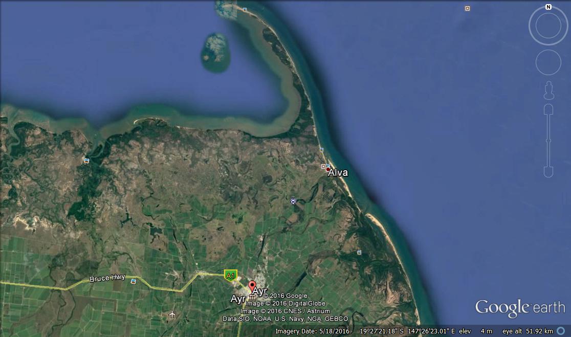
And it is here in this missive that I can announce I've discovered a new trick....the use of Google Earth photographs. I have recently become more aware of the wonderful advantages this imagery provides when trying to gain an initial impression of a new destination and its surrounds (yes, yes....troglodyte Marshie again struggling out his cave into the light of modern technology!)

As this photo shows, Alva (Beach) lies on the coast just south of the distinctive and impressively hooked peninsula which is Cape Bowling Green (despite many enquiries I could not get to the bottom of this unusual name...my quest continues).
Its name is not the only thing which is unusual about Cape Bowling Green. It is the longest sand spit in the country, stretching northwards for just under 15 kms from the south-eastern corner of Bowling Green Bay. It may seem somewhat odd to be commenting about sand at a beach destination....I mean after all what else would one expect to find (apart from mud flats!) but here the sands are different.

One of the first things I noticed about our pending destination when I was poking about in Google Earth was that the waters of Alva Beach appeared to be nothing more than a channel between the coast and a long sand bank.

This turned out to be exactly right, and not only that, these sands are constantly on the move, continually being sculptured into ever changing channels and banks by the irresistible force of the waves (thanks to 'tripadvisor' for this photo).
So what is so different about this part of the coast, and where does all this sand come from? The answer is the mighty Burdekin River which dumps incalculable tonnes of fine silt into the ocean at its mouth about 40 kms south of Cape Bowling Green. These sandy deposits are gradually pushed north under the influence of the prevailing southerly waves along the coast and up to the cape.
Interestingly, when we had first crossed the Burdekin River via the famous (and somewhat intimidating) Silverlink bridge it had been, like now, the dry season. The flow had been reduced to a few small channels, and we had commented at the time about both the width of the river and the sandy nature of its bed.

This photo, courtesy 'zontadistrict22', will hopefully provide a much better impression of what we saw than my mere words. These huge silt beds extend for miles and miles along the river,

and when you see what happens to this waterway during the height of 'the wet', (thanks 'snowys') the extent of the sand deposits along the coast near Alva Beach from the mouth of the Burdekin to Cape Bowling Green become much more understandable.

And these soft, shifting sands can be very unfriendly. Apart from the dangers of rip channels for those swimming, any taking to the beach in their 4WD's should do so with caution. For the uninitiated, or those who chose to ignore the many warning signs, they can be treacherous on a rising tide, as this photo of two vehicles terminally stranded in the morass of soft sand like a pair of beached whales (courtesy 'my swag') so amply demonstrates.
But of course, before we could see all this for ourselves, we had to get there. We treated the noise of the Proserpine pool attendant next door as an 0600 hours alarm clock and, given that our stay here had been 'minimalist' as far as set up went, we had little to do to hitch and be on our way. This stretch of the Bruce Highway is one with which we were very familiar.
 We covered the 160 kms to the Burdekin River crossing in a canter, where we again confronted the somewhat intimidating steel arches which make up the impressive bulk of the Silverlink Bridge. We remain surprised that there are not significant speed restrictions applied to this section of the highway, but irrespective to that, this crossing is one where those new to the towing game stand out....they reduce their speed to a crawl.

Rather than take the sharp left turn in Ayr to continue on north-west up the Bruce to Townsville, we made our way into the backstreets and

on into the cane fields to the north-east.

Here a break in the weather (it was not to last) meant that cutting was in full swing and this massive mechanical 'mantis' was setting up for a full blown attack on the quivering crop.

Operations at the nearby Willmar mill were also well under way. With the delays the rain has caused this season many of the mills were now working to absolute capacity whenever there was a break in the weather.
In previous years we had heard much about the fishing to be had at Alva Beach, the small coastal township in the Burdekin region of Queensland, just under 20 kms north-east of Ayr. We had overnighted in Ayr on our return south last year and agreed then that this is a town in which we must spend a few days, but not at this stage. We were continuing our quest for new coastal destinations, and at Alva Beach we found one which was, for me at least, utterly fascinating.
As this photo shows, Alva (Beach) lies on the coast just south of the distinctive and impressively hooked peninsula which is Cape Bowling Green (despite many enquiries I could not get to the bottom of this unusual name...my quest continues).
Its name is not the only thing which is unusual about Cape Bowling Green. It is the longest sand spit in the country, stretching northwards for just under 15 kms from the south-eastern corner of Bowling Green Bay. It may seem somewhat odd to be commenting about sand at a beach destination....I mean after all what else would one expect to find (apart from mud flats!) but here the sands are different.

One of the first things I noticed about our pending destination when I was poking about in Google Earth was that the waters of Alva Beach appeared to be nothing more than a channel between the coast and a long sand bank.
This turned out to be exactly right, and not only that, these sands are constantly on the move, continually being sculptured into ever changing channels and banks by the irresistible force of the waves (thanks to 'tripadvisor' for this photo).
So what is so different about this part of the coast, and where does all this sand come from? The answer is the mighty Burdekin River which dumps incalculable tonnes of fine silt into the ocean at its mouth about 40 kms south of Cape Bowling Green. These sandy deposits are gradually pushed north under the influence of the prevailing southerly waves along the coast and up to the cape.
Interestingly, when we had first crossed the Burdekin River via the famous (and somewhat intimidating) Silverlink bridge it had been, like now, the dry season. The flow had been reduced to a few small channels, and we had commented at the time about both the width of the river and the sandy nature of its bed.
This photo, courtesy 'zontadistrict22', will hopefully provide a much better impression of what we saw than my mere words. These huge silt beds extend for miles and miles along the river,
and when you see what happens to this waterway during the height of 'the wet', (thanks 'snowys') the extent of the sand deposits along the coast near Alva Beach from the mouth of the Burdekin to Cape Bowling Green become much more understandable.
And these soft, shifting sands can be very unfriendly. Apart from the dangers of rip channels for those swimming, any taking to the beach in their 4WD's should do so with caution. For the uninitiated, or those who chose to ignore the many warning signs, they can be treacherous on a rising tide, as this photo of two vehicles terminally stranded in the morass of soft sand like a pair of beached whales (courtesy 'my swag') so amply demonstrates.
But of course, before we could see all this for ourselves, we had to get there. We treated the noise of the Proserpine pool attendant next door as an 0600 hours alarm clock and, given that our stay here had been 'minimalist' as far as set up went, we had little to do to hitch and be on our way. This stretch of the Bruce Highway is one with which we were very familiar.
 We covered the 160 kms to the Burdekin River crossing in a canter, where we again confronted the somewhat intimidating steel arches which make up the impressive bulk of the Silverlink Bridge. We remain surprised that there are not significant speed restrictions applied to this section of the highway, but irrespective to that, this crossing is one where those new to the towing game stand out....they reduce their speed to a crawl.
Rather than take the sharp left turn in Ayr to continue on north-west up the Bruce to Townsville, we made our way into the backstreets and

on into the cane fields to the north-east.

Here a break in the weather (it was not to last) meant that cutting was in full swing and this massive mechanical 'mantis' was setting up for a full blown attack on the quivering crop.

Operations at the nearby Willmar mill were also well under way. With the delays the rain has caused this season many of the mills were now working to absolute capacity whenever there was a break in the weather.

Sixteen kms through the cane country out of the back of Ayr and the well trimmed hedges of the Alva Beach Tourist Park came into view

and we duly hove to at the park office.

We had been warned that this can be a very busy park, one to which dedicated fisher folk make an annual and extended pilgrimage each winter. This was soon more than apparent.

We had been allocated a site quite near the entrance. It was a little tight to access, but once we were on it was more than acceptable with a good slab, bordering hedge and a carob standing sentinel at the front.

Although this was not the most sheltered spot in the park as we later discovered, it did have some other advantages. We were directly opposite the lawned assembly area between the camp kitchen and the ablution block.

The large and well equipped camp kitchen was well used by many

as was the adjacent lawn area where an afternoon assembly for happy hour is encouraged by the park management.

The heads are dated but reasonable

but the park pool is something out of the box.....large, sparklingly clean and even boasting a lap line!
As with many parks situated well out of a major town, communications was a problem, and here out site provided another advantage. We were close enough to the camp 'hotspot' to be able to communicate from our van rather than having to wander over the the camp kitchen and here at Alva Beach the park provides free wifi which is always welcomed.
We did sortie out and about on a number of occasions whilst here, both on foot and mounted in our mechanical metal motor, gaining familiarity with the various beach access points, of which there are several, and determining whether or not the reports about this being a fishing paradise were exaggerated. As is so often the case, Alva Beach is a spot where ownership of, or access to, a floating platform is highly desirable, but from the observations I made, good numbers of the most desirable whiting and flathead are on hand for those prepared to manage the winds and the currents and fish from the beach along the channels between the shore and the sandbar.
The end result of our venture to this fascinating and very different part of the coast was a decision to return here for some time on the 'tourist shoulder' either in May or September, when the weather should still be acceptable and the place less crowded. Accordingly, I've not bothered with photos of the town, the beaches or the real surprise.....the Alva Beach Surf Lifesaving club, one of the first established in Queensland.
This will be the project for our return visit, probably on current planning estimates, in May next year.
Nice write up of Alva Beach, thanks Liz and Pete!
ReplyDelete