I cannot leave St George without sharing one of those wonderful signs we find all over the country, signs which invariably make my day.

We actually spotted this one on the highway, where a photo was impossible. I was chuffed to find the rig later pulled into our camp. This is what appears on the rear window of the small vehicle being towed by the large motor home occupied by this wit.
So it was with a chuckle we saddled up yet again for the relatively short leg of a mere 170 kms to our next chosen overnight stopping point.....the tiny town of Hebel.
And that, of course, raises a very good question, "where the hell is Hebel?" And the answer is.....a mere tad shy of the Queensland - NSW border. Allow me to call again on the able assistance of Google Earth for some perspective.

Here we can see the road south out of St George which dog legs its way into Dirranbandi before continuing on south-west to Hebel. The State border is represented by the thin, horizontal line just below the town. Apart from providing some idea of where we were travelling, I've included this shot for another reason. I am sure you can see the large area just to the north-west of the highway which is obviously under some form of cultivation. Well, dear readers, let me present the famous/infamous (depending entirely on which 'eco corner' you occupy) Cubbie Station, the enormous cotton farm which has created so much controversy over the years.
So just how big is it really? Well, the highway distance between Dirranbandi and Hebel is just over 75 kilometres.....I think that says it all. This place is huge, as these few statistics demonstrate.
Cubbie, which is located on the floodplains of the upper reaches of the Darling and Barwon Rivers, is currently owned by a consortium consisting of Chinese, Japanese and Australian companies (this group bought the property in 2013 for $240 million (but only after the purchase was approved by the Australian Foreign Investment Board).
It was created by amalgamating 12 floodplain grazing properties to give a total holding of 93,000 hectares. Significantly, this amalgamation also gave Cubbie a total of 51 water licences. These entitle the taking of 460,000 megalitres, which amounts to the equivalent of all the downstream irrigation entitlements in north-western NSW.
The dams which hold the property's irrigation water stretch for nearly 30 kilometres along the Culgoa River. These are deep storage facilities, designed to minimise evaporation.
In an average year the station uses 200,000 megalitres of water, whilst in a good year (and surely this will be one of those) the cotton and other crops which include wheat, are irrigated with up to 500,000 megs, generating profits ranging between $50 - $80 million annually.
Mind you, like all agricultural enterprises, Cubbie Station has to deal with the bad years as well as the good. In 2006, for example, the dams were only filled to 1% capacity because of the drought, and only 200 hectares of cotton was planted. In October 2009, the original consortium which owned the property went into voluntary administration as the result of the poor rainfall over the preceding five years. Even the debts were huge..... a mere $300 million!
This property has been the subject of criticism for many years, the argument being that its massive water entitlements allow it to extract from the system to the detriment of all others reliant on the water of the upper Murray Darling system. The current owners go to great lengths on their very informative web site to disprove this. If their figures are accurate they make a good case, but for any interested I'll let you make your own judgements.

Well, after this short 'virtual detour' let's get back on track....the real track that is....in this case the Castlereagh Highway. We did comment that this country road had featured more in this trip than any past. You may recall our sojourn in Mendooran, the oldest town on the Castlereagh, earlier in the year.

Not too far south-west of St George we came across the first of what would be many road side Cypress Pines, a timber which was the source of a thriving cutting and milling industry in this area at the turn of the century. They do make a pleasant visual change from the usual gums.

Speaking of which, there were stand after stand of these as we drove off the low ridges on the approach to Dirranbandi, a town which lies smack in the middle of a huge flood plain and which can be cut off for days.

We soon passed a reminder of what had been happening but a week or so ago, when access through here was impossible. In fact, at one stage not too long past, we were beginning to wonder if we would actually be able to get through to our desired homeward bound destination of Lightning Ridge at all.


As we approached Dirranbandi we were again heartened by the information posted on this advisory sign. Our road ahead was clear!

Indeed it was as we made our approach into the town of Dirranbandi, where, as we had so often experienced in the past, the highway forms the main street of the town.

We had previously decided to take a break here and have a good wander around. Where to park was the next question, not that there was anything approaching a flurry of activity here early on a Saturday morning. A spot off the road close to the historic railway station and town park seemed an ideal choice.
As we had already anticipated, and soon discovered, it does not take long to explore the town CBD, but as I have previously explained, one of my best friends grew up here and began what went on to be an illustrious flying career with Qantas as a result of taking to the air from the Dirranbandi airfield many years ago.

 We began our early morning jaunt at the now defunct Dirranbandi Railway Station. Rail came to this town in May 1913, but has long since been ceased to operate along this line. The old station building now houses the town museum, but oddly enough this was not open at eight in the morning.
From here we could look back along the line which parallels the main road into the town where an old crane and shed stand as reminders of busier days.

At the front of the station building some interesting local art works decorate the surrounds,

which lie adjacent to the well maintained central town park. Here we came across the first of two statues which grace this area. Shown in full stride, this is the memorial to a very fleet footed local, Tom Dancey.

I'll let the plaque tell his story. I could not help but notice that Tom's victory resulted in a significant improvement to the cash position of his trainer......but what about Tom? I'll bet he would have rather walked away with the money instead of a ribbon and a cup if he had the choice.

Next to Tom's statue stand these 'cotton bales', far less evocative than their neighbour but with probably greater local significance. Here one Des Stevenson is remembered for his pioneering work in establishing what is now a massive local industry as we have already seen....cotton.
Given that the permanent population of 'Dirran' as it is universally known (around these parts at least) is something sub 1,000, we were surprised to find how well the town is served by cafes and motel accommodation, in addition to its large pub. We suspect the answer lies in the seasonal influx of workers associated with the cotton and other agricultural ventures which swells the town numbers considerably.
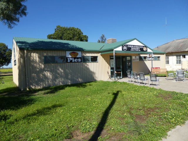
Those wishing to munch on a tasty hot pie or any other baked goodies will find their needs met at the Green Frog cafe and bakery at the far end of the park. This was actually open as we strolled past and I remain amazed the co-pilot did not break off in search of a chocolate donut. But the cash register of this august establishment did not ring with the receipt of any coin from the Mobile Marshies who continued their ramble down the main street,

where we next came across this surprisingly large motel.

Directly opposite is the equally impressive communications tower which rises far above the roof of the local Post Office (and acts as a local landmark for miles around)

beyond which we took in a couple of what we discovered were pretty typical Dirranbandi homes.

At this end of the CBD the highway takes a left hand turn. Strategically placed on the corner is the local 'Servo', and that's not just me making loose with our language

as the sign on the wall above the door attests. Pragmatic to the end these outback folk.....why pay a painter to add all the extra letters involved with the full title of 'Dirranbandi Service Station' (assuming the wall was long enough!)

About turn and off to see the other side of the main drag where a view along the first side street at this end of town presented us with two of the bottle trees which abound throughout this area standing with bloated trunks (well, one is still working on that) in front of the rooms of the motel section of the local pub.

For those eschewing the tempting delights of a freshly baked pie or pasty (yep, Queensland bakeries actually make pasties, unlike every other State except good old SA), the Dirranbandi cafe and take-away does a fine line in just about everything else one could desire for breakfast, lunch or dinner

and if that doesn't do the trick, one can buy all that is needed for a home cooked meal from the indisputably most colourful commercial premises in the street,

or repair to the cool interior of the impressively large Dirranbandi Hotel/Motel.

Speaking of colour, the locals have done their best to brighten the CBD footpath with a series of little mosaics, quaint but certainly bright.
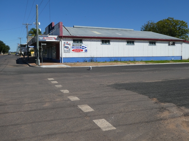
At the next junction we saw evidence of the fact that all has not been well with every commercial venture here in the town. The Five Star supermarket building is sadly empty, but at least the arrow on its wall showed us where to find the local caravan park, which we did check out later.

On the opposite corner the story is very different. Here the flapping entreaties of the promotional flags invite those passing by to sample the large and very good range of goods on offer at this clothing and work wear store.

We had now reached the end of the Dirranbandi CBD.....the road on which we had travelled into the town stretched off in the distance

and, looking the other way was the scene which had presented itself on our arrival.

Reminders of the recent rains were everywhere. Sheets of water were still glistening in the open spaces between the road and the old railway line.

As we made our way back to our mobile home and a very miffed black cat who was totally put out by the fact that he had to go back into his cage again, our route took us past the largish building which bookends the park. This is one of those 'jack-of-all trades' premises,

as the nearby sign demonstrates. I'm sure they are quite widespread in these small country towns, but we had not come across one so well advertised since travelling through Mataranka in the Northern Territory.
Now it was into the Cruiser and a final jaunt down the relevant side street to find the local caravan park.

En route we discovered the almost incongruously modern 'Dirran' Civic Centre,

the local RSL HQ

and the starkly white Catholic School which looked absolutely at home in its surroundings.

Opposite the school buildings the Dirranbandi nunnery, which we had been told was directly adjacent to the caravan park, was completely hidden behind surrounding trees

but sure enough, right next door was the entrance to what we could see is a more than reasonable looking park where the owner specialises in taking guests (for a fee of course) on a guided tour of the nearby Cubbie Station. What an enterprising chap he is.

Finally, on this side of the town we also came across the mass of low buildings which are the Dirranbandi hospital, set in lovely grounds and framed by the splash of colour from the street bougainvillea.
As we take our leave of this interesting little Queensland town let me present you with a reminder of why we were so glad to have been able to get in and out unsullied at a time when there was heavy rainfall about the district and in the catchments.

I have alluded previously to the fact that Dirranbandi lies smack in the middle of a flood plain and when it floods here it floods. Fortunately previous disasters prompted the construction of what are now very effective levee banks which protect the town from inundation, as this aerial shot by 'aerometrex' of the 2012 floods shows only too well. As you can see the entire town is surrounded by a sea of muddy floodwaters.

This photo, courtesy of the 'Courier Mail', also provides graphic evidence of just how necessary the town's levee banks are, and how well they work.
At one stage in recent years the town was cut off completely from contact with the remainder of the country for six weeks. From what we had seen to date this revelation came as no surprise, and indeed as we continued on to Hebel, we came across more evidence of the effect of heavy rains in this area.

From Dirranbandi, we didn't have far to go. This was any easy day on the road distance wise.

As we continued on past the incredible stands of yellow flowering weeds which had just thrived in the wet all through this area

we were soon on full alert again....surely we would not be stopped now.

Not today, but we did have to negotiate this wash away with some care (fortunately one side of the carriageway was still intact)

and a little further along we had another reminder of what had been an impassable highway a few days previously.

And here we were, safe and sound on the outskirts of Hebel......tiny, tiny Hebel,

where we were to discover that there is some (albeit limited) truth to this welcoming town sign.

But first, of course, we had to find our digs and settle in. In Hebel that's not hard (finding the park that is). As we made our approach to the town, it was obvious that there is not much to it. And that is almost an understatement.
The Castlereagh Highway makes a dogleg turn here at Hebel, and in this panoramic shot,

taken at the corner, I have been able to capture almost the entire town, well at least the three main buildings, the general store, the pub and the community hall.

We were to see much more of the first two, particularly as the town caravan park is directly behind the store and managed by its proprietors.

We dutifully drove past the entrance and around the corner where we parked on the huge bitumen apron which we later saw was often crowded with vans and road trains, despite its size.

After the usual formalities our host Barb (more of her and her husband Ralph later) escorted us to our drive-thu site.

Despite the fact that we were right next to the highway, we were very comfortable. With a flat patch (no need for levelling ramps), and conveniently located taps and power box, I had the van connected and the awning out for necessary shade in no time. And for once we were glad of the recent rains....there was not a grain of dust in the air which I am sure is not usually the case.
We were only spending one night here, and although Hebel does not occupy much real estate, there was plenty to see, which I'll have pleasure sharing in my next missive.
No comments:
Post a Comment