As I have mentioned previously, the Salamanca area, and its famous Saturday markets, is one of Hobart's prime tourist attractions. Hopefully I can show you why. I have not actually been to the market....I really do not like crowds (Liz did once and returned to the van unladen with goodies....whew!) but we did wander through the precinct and beyond to the waterfront as part of our foot tour of the city when things were a little less hectic.
Again, I have struggled with my editorial pen but have at least managed to reduce this presentation to about 50% of the photos I have on file!

 Let's begin with a stroll east along Salamanca Place, with the edge of St David's Park (and its wonderful memorials) on our right.
On the same side of the road as the square, we soon found ourselves gazing at the long low building which houses Tasmania's Supreme Court (and which was impossible to capture in its entirety).

At the end of this seat of justice we came to the beginning of the row of old Georgian stone warehouses and other buildings which line Salamanca Place here at the waterfront.

A long park lies between the roadway and the docks (you can see the buildings of Princes Wharf at the left of this photo) and it is here that the stalls and tents of the famous market spring up like seasonal mushrooms each weekend.

At this western end of what is really 'restaurant, pub and cafe central', and off to the left, are the gardens of Parliament Square,

behind which, unsurprisingly, stands Tasmania's Parliament House, another long stone building which was originally designed as a customs house.
With the achievement of self-government in Tasmania in 1841, this building served as the seat of government as well as fulfilling its original purpose. This situation continued until 1904 when the customs offices were relocated. I have had fun imagining some of the corridor encounters during this period!

For me, the solid square stone warehouse buildings of Salamanca Place just shout 'Old Hobart Town' and are another example of the marvellous manner in which Hobart history has been preserved and maintained.

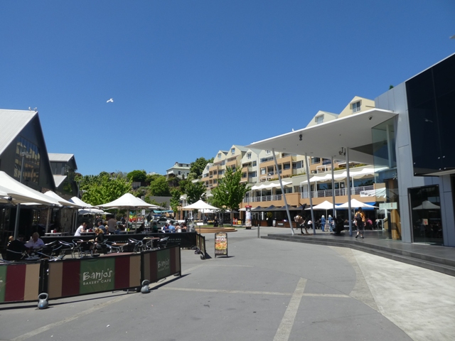
Now, of course, the bustle and noise which would have been part and parcel of the unloading of the goods in ships' holds into the many warehouses and stores along this precinct has long since been replaced by the bustle and noise of tourists and locals, all steadfastly engaged in enjoying themselves. Kerbside tables feature right along this strip, as this shot, looking back west, shows. Mind you, fine sunny weather helps!

We wandered along untroubled (at this stage) by the siren smells of food and coffee, until we came to the corner

of one of the two small streets which enclose the ends of Salamanca Square which lies behind Salamanca Place. We were off to take a look.

Here the old and the new rub shoulders. Leading the charge for the 'new' is the unmistakable Mercury building, home to Tasmania's daily newspaper,
immediately beyond which stands a group of apartment buildings dominating the southern side of the square. But as you can see, the other side of this delightful precinct is 'all eating and drinking'

where al fresco tables and chairs spill out onto the square from the many restaurants and cafes housed in the old stone buildings immediately behind Salamanca Place.

The fun and frivolity of the square is well exemplified in this bit of bronze whimsy

where some visitors just cannot help but get in on the act!

Towards the far end of the square

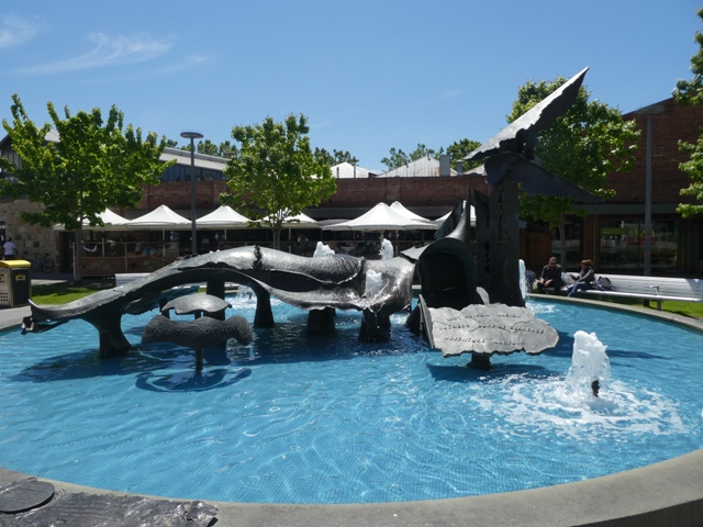
whilst the art work is not forgotten either. This extraordinary fountain

has a serious theme as representative of the State's history and development

but much of the rest, such as this colourful 'teepee',

the chess set at the base of the end granite wall

and these metal cut out figures all demonstrate. The stone archway which can be seen just beyond, had special significance for your scribe.

This magnificent old stone building is home to one of Hobart's best known and finest Greek Meze meal, one of my favourite munches. According to many of my UN colleagues, who darkened this doorway more than once, the reputation held by this restaurant is more than justified, and let's face it, those of us who served in Cyprus are well versed in these matters!
Circumstances prevented us joining our friends previously, but I fully intend to rectify this situation when we return to Hobart in the New Year....and to hell with the expense, which I was also told is not exorbitant.

This house of fine Greek cuisine is at the head of the narrow alley which took us back to Salamanca Place

and the beginning of our wanderings along the Hobart waterfront where the trees of the marketplace line one side of Castray Esplanade and the long dockside building of Princes Wharf the other.
Before we embark on this stroll I think some perspective is in order, and as usual it has fallen the lot of Google Earth to come to the rescue.
Here we can see how the waterfront docks of Sullivans Cove lie at the foot of the city of Hobart. The green area at the bottom left is St David's Square, with Salamanca Place leading from it to the open space of Parliament Square the right. From this point, stretching further to the right, you can see the trees of the Salamanca market place with the line of the Princes Wharf dock buildings immediately above.

Above this most southern of the wharves, is the relatively stubby Brooke Street pier and then those of Murray and Elizabeth Streets. Beyond the Elizabeth Street Pier, the roadway of the Franklin Wharf separates the two dock areas at the foot of the city from the jetties and finger wharves which form the Kings Pier Marina. Of the two inner enclosed dock areas, the lower is the famous Constitution Dock whilst the other is known as Victoria Dock.
Hunter Street, one of Hobart's most historically significant, forms the northern boundary of Victoria Dock and separates the basin from the major wharves beyond, the spot where the cruise ships come alongside and the commercial shipping loads and unloads (around the corner at the top of the shot.)
I trust this make some sense of an area I have found very difficult to actually describe, and the relationship between the city itself and the waterfront, something I just loved and which is, in itself, a major attraction for only for us tourist types, but also the Hobartians.


past the end of the Princes Wharf building

and on to the junction of Murray Street at the northern end of the Parliament Square gardens

where we took a final glance at the end of the Parliament House building.

The comparatively short Murray Street Pier building is home to apartments and restaurants,
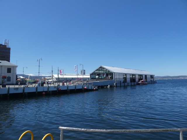
unlike its neighbour across the intervening basin.

The glass fronted Brooke Street Pier building is much more tourist orientated. Here we found a booking office for the famed MONA (the ferry service to this art museum, located far up the Derwent, also leaves from this area), an extensive whisky and gin tasting counter, a rather up-market restaurant and boutique shops.

With the rather bleak bulk of the Marine Board building (complete with its unique roof top wind turbines) overlooking it, the Elizabeth Street Pier

was hosting a regular and important visitor on the day we strolled past.
This two masted brigantine-rigged sailing ship was modelled on a mid 1800's Boston schooner. This vessel, built almost entirely of local eucalypt, huon and Oregon pine (recycled form old boats and buildings) is named 'Windeward Bound', a delightful play on the name of the builder of the original schooner, Lewis Winde.
The modern version, which is Hobart based and is commonly used as a sail training vessel for young people, completed a circumnavigation of Australia in 2002-3 to celebrate the 200th anniversary of that same feat by Matthew Flinders.

What a picture she made with the buildings of the waterfront and tree lined Elizabeth Street as a backdrop.

The large Elizabeth Street Pier building houses rental and holiday apartments, and naturally, fine seafood restaurants. It presents an ideal location from which to watch yachts cross the Sydney-Hobart finishing line.

And now we came to the real working end of Sullivans Cove. Immediately beyond the Elizabeth Street Pier is the Kings Pier marina, the largest of the marina basins in which moorings are provided for both commercial and pleasure craft, of all shapes and sizes. In this particular shot we can see one of the fleet of powerful cruise boats used to take sight-seers around the bottom end of Bruny Island and around the coast near Port Arthur. I'll have much more to say about this tourist success story in a later blog.

The docks and finger wharves of this marina are a clutter of craft, mainly private pleasure vessels

but did include a few of the local fishing fleet which were tied up

alongside the outer edge of Franklin Wharf, the roadway which joins one end of Sullivans Cove to the other. A swing bridge (the section enclosed either side by the rail fence) allows access from the waters of the Kings Pier marina to the two 'inner sanctums'.

Constitution Dock, with its floating seafood restaurants on its far side, is the first of these. What a different scene this will present with the controlled chaos which will be the arrival of the Sydney-Hobart fleet just after Xmas.

Its immediate neighbour to the north is Victoria Dock, where the crowded cutters of the commercial fishing fleet lie calmly and securely under the watchful gaze of the Grand Chancellor Hotel, Hobart's largest (by far!) The northern boundary of this basin is Hunter Street about which I'll have more to say shortly.

This is another shot of the bridge and the entrance channel to these two docks, with the buildings of the old Henry Jones jam factory in Hunter Street in the background.

As we made our way across the Franklin Wharf (such an odd name for what is predominately a road!) towards Hunter Street

we came across yet another example of waterfront street art, this time in the form of a tribute to Louis Bernacchi taking a self portrait with his dog Joe.
Louis who? I asked the same question and was amazed to discover that the redoubtable Mr Bernacchi, who was raised in Tassie, was a man of physics specialising in terrestrial magnetism. Right, we all knew that, of course. But there was much more to Louis than the crusty cloisters of academia.......he toddled off to Antarctica twice, firstly in 1898 with Borchgrevink (I'll let you find out more about him if you choose) and again with the much more widely known and acclaimed Robert Scott in 1901. The things you learn on (and after) a walk around Hobart!

On a completely different note, these statues were to be found wending their downcast way across the open space in front of the large apartment block which lies along the northern edge of the Kings Pier marina. It was not difficult to recognise these as members of early Hobart's struggling poor, many of whom lived nearby as we shall soon see.

In front of the apartments, at the junction of Franklin Wharf and Hunter Street stood this rather odd looking memorial

to 150 years of life in Hobart. In itself this was of little interest, but not so the ring of information boards which surrounded it. I have drawn extensively from them,

beginning with this sketch of Sullivans Cove as it was in 1879 in which the basins which are now Constitution and Victoria docks are quite easy to make out.

Hunter Street, here seen looking east across the corner of Victoria Dock, is the site of some serious and significant Hobart history. I know I planned to eschew this sort of detail, but in this case I couldn't resist.
But I am being lazy about it. Rather than bash away at the keyboard, I've pieced together the text from one or two of the information plaques at the end of Franklin Wharf which tell the story more than adequately.


So, as you can see, those who established their businesses here on the docks along Hunter Street all those years ago created a legacy which lives on today (and has been thoughtfully preserved) in much of Hobart.
Hunter Street and its immediate surrounds did have a darker side, however.


The 'Drunken Admiral' is now one of the many seafood restaurants which are dotted throughout the waterfront area. I'll not bother you with a review of its offerings other than to say they are mixed, and it is far from cheap.

But irrespective of what goes on inside this building today, there is still an alley next to it,

and as we soon discovered, the homes here now are a very far cry from the hovels and cottages of Shades Row. The narrow entrance opens into a large courtyard (serviced by another larger driveway, obviously) where the old wall of the rear of 'The Admiral' is now in the architectural minority amongst the modern apartment blocks

which have now taken over this area.

But as we emerged back onto Hunter Street from this enclave of modern Hobart, we were given a small reminder of the days of yore.
There is so much more to the history of Hunter Street and its immediate surrounds, but I am sure you have had enough by now. Let me conclude this waterfront wander with a few final photos which are far better than any I could manage(not least because my feet were stuck firmly on the ground!).

In this shot (thanks to 'booking') we can look over the southern end of the waterfront area from Murray Street to Elizabeth Street.

This aerial provided by 'marasinenews' shows the entire waterfront and commercial docks area with the high rise of the city an Mount Wellington in the background.
And, just to provide a comparison, this is what things used to look like so many years ago in Sullivans Cove (again I am indebted to Geoff Richie and 'On the Convict Trail')


Finally, in one of those odd coincidences of the sightseeing world, as we were (by now) dragging ourselves back to the Cruiser which was parked behind the Old Woolshed, I came across this odd looking piece of street sculpture.
A closer look revealed that this 'wall', which stands on the site of Hobart Town's old Wapping area, presents a stylised history of the area and its development over the years. As they say, 'the things you find'!
Well, dear readers, that is it for Hobart itself for some time. I suspect if you have made it this far you may be struggling to believe that I have culled the photos of this area by over half, and really did not do Hunter Street entire justice (apart from one photo reference I've not even mentioned the famous Henry Jones jam factory, for example...a story for another day perhaps).
But enough is enough!
We shall be back here just after Xmas. As an erstwhile off shore yacht racing crewman, the chance to wander around Constitution Dock when the boats of the Sydney-Hobart fleet are rafted up (those which haven't already turned around) is irresistible.
For our next Tassie adventure........a complete change of pace when we head off south to the delightful little timber town of Geeveston (where a deal of the current ABC TV show 'Rosehaven' has been shot), and, whilst there, even further south, as far as one can travel by road in Australia.
No comments:
Post a Comment