Seriously.....!
Cockle Creek is the most southerly point in Australia accessible by road, although a few of the walking tracks nearby do take hikers further towards Antarctica, but not by much. We were off to have a look.
This was an occasion on which I as not driving. We were travelling as guests of our Margate hosts and for a couple of reasons this offering will be constructed in reverse, that is we shall be visiting the sights as we came back from the far south, rather than as we approached.
I should also note that our trip down from Geeveston did take us through the towns of Dover and (with a detour) Southport. We stayed at both later, and I'll have more to say about them then, so for now we begin this tour just south-west of Southport, at the historic Ida Bay Railway complex.
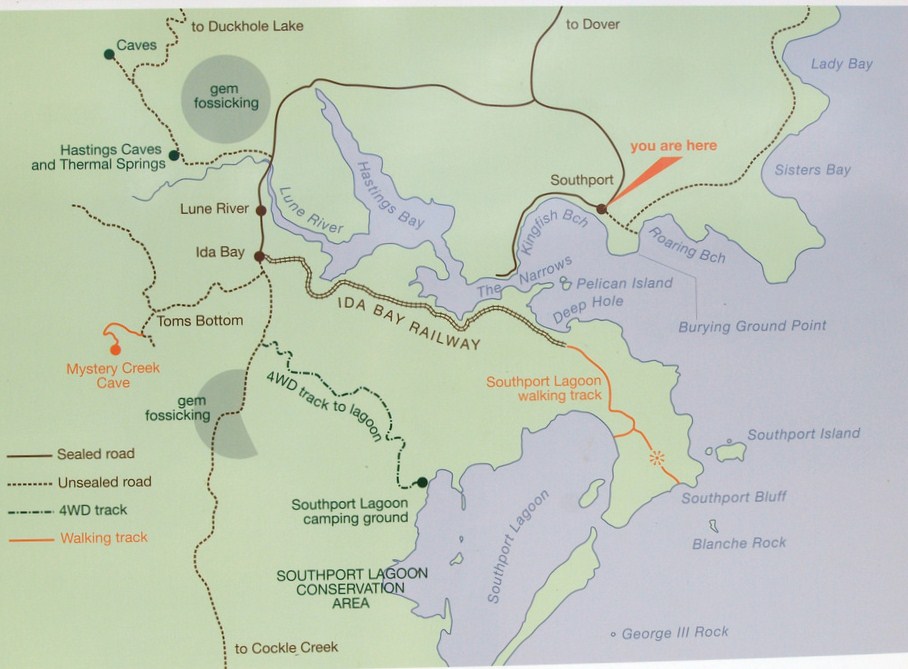
Hopefully this map will give you a better idea than my mere words as to exactly where we were and where the railway line runs. And as you can see, in this area the coastline of Tasmania is another mass of inlets and bays. These do provide for some spectacular scenery, but can be quite confusing for the uninitiated in terms of knowing just quite where one is at any time.
We were travelling down the road which brought us out of Dover, by-passing Southport, and on around the northern tip of Hastings Bay, through Lune River to Ida Bay before we continued south along the track to Cockle Creek.

The Ida Bay railway is no longer in commercial use, a situation which has existed since June 1975.
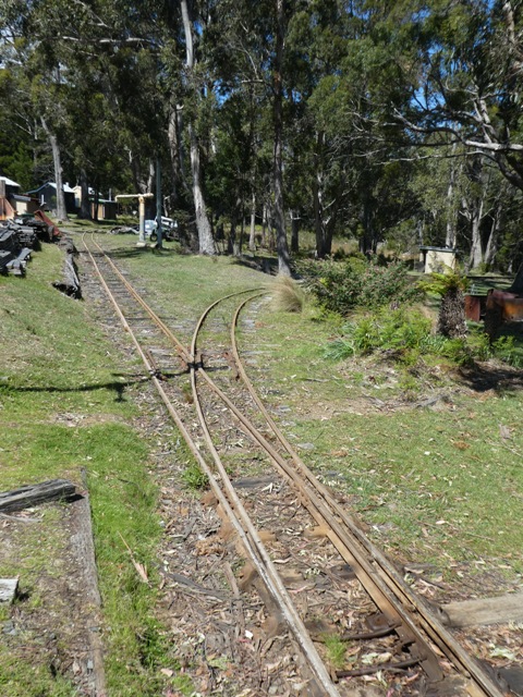
Its narrow gauge line (2 feet in the old scale, or for the more modern, 610 mm) was laid down in 1922 to provide a means by which to transport limestone from the quarry near Lune River to a wharf which had been built on Ida Bay itself at a spot known as Brick Point. From here the limestone was shipped north through the D'Entrecasteaux channel by river boats to Electrona, located quite co-incidentally, just south of Margate where we were currently staying. Here the limestone was used to produce calcium carbide, a very significant industrial product. Apart from its use in the steel manufacture of steel, it was also the source of acetylene gas and was used in the production of synthetic rubber and plastics.
After WW2 the workshops and operational headquarters of the railway were moved to the present location on the Cockle Creek Road. Silting of the Lune River forced the closure of the Ida Bay wharf and the line was extended to a new loading dock at Deep Hole.
When road transport finally overtook the use of boats, the Ida Bay railway was potentially consigned to history, but in 1977 the Tasmanian Government bought all the remaining infrastructure and on 20 December of that year, the tourist attraction we were now visiting was declared officially open.

Today, visitors can wander through the museum (when open!) and book a trip on the train which still takes tourists to Deep Hole and back past some quite interesting historical sites, including one block near the old township which was bought in 1863 by one John Woodcock. John who? The composer of that well known and famous English folk song 'D'ye Ken John Peel'.....that John Woodcock!

We chose not to join those propping their bottoms on one of the old railway carriage seats (as seen here courtesy of the official Ida Bay website)
nor did we indulge ourselves with any of the offerings from the nearby cafe which appeared somewhat tired and less than sparkling and where Andy noted that the price of a humble egg and bacon roll was $11.50 no less.

But, as we wandered about the heritage buildings we did spot something which brought us up short.

We could not believe our eyes. A poster promoting the annual music festival held in the Southern Flinders Ranges town of Melrose in our home State, a town I know very well for a number of reasons. How extraordinary!

But enough of Ida Bay and its old railway....it was time to farewell the bitumen, hit the dirt and make our way further south for the remaining 30 kms or so to Cockle Creek, where sections of the road were little more than a track which took us through quite heavily timbered country.

At this point let me refresh your memories as to where we were actually heading. Cockle Creek is right at the southern tip of Recherche Bay, a place of historical significance in itself (more shortly)

And now.....fast forward to the parking bay at the end of the road which had brought us here.

From this point a short track through the bush took us

to a point where we could look out over the pristine waters to the shoreline of this section of the bay,

or, in the other direction, out towards the open sea. The plaques erected here were most informative.
One reminded us of where we were and detailed the various walking track options

which began at this point. Unfortunately we had no time to meander along any of these.

Others, such as this, were of far more interest to yours truly.
We had first become aware of this valiant French admiral three years ago when in Western Australia. He commanded two ships, 'Recherche' and 'Esperance'. D'Entrecasteaux, whose full name was something of a real mouthful....Antoine Raymond Joseph de Bruni d'Entrecasteaux (BD for short)....was wandering around this southern section of the globe in the vain hope that he could discover the fate of one of his countrymen who had preceded him to the Great South Land.
The French explore Laperouse had sailed all over the world some years before, and had actually landed at Botany Bay in January 1788, just as Governor Arthur Phillip was trying to move all his troops and others north to Sydney Cove.
Laperouse was offered every courtesy, and after spending six weeks in the fledgling colony of New South Wales (where clearly the English had just beaten their rivals in claiming the lands for the Mother Country), he headed out to sea again, ostensibly en route back to France. He and the members of his expedition were never seen again.
It was whilst sailing around the bottom tip of Western Australia, looking for any trace of Laperouse, that BD's two ships were beset by a raging storm. He took shelter in a bay which he later named after one of his ships, Esperance.
Recherche Bay, where we were now standing, is the second of two Australian bays named by BD after one of the two ships of his expedition. In what seems to have been a bit of a habit of his, it is the second he discovered as the result of having to scuttle for shelter in the face of a storm.
He came ashore here twice, firstly in April 1792 when he spent six weeks replenishing his supplies and exploring, and again in January 1793 when he laid up for just over three weeks.
I was particularly taken by comments he recorded in his log in January 1793 when describing Recherche Bay:
"It will be difficult to describe my feelings at the sight of this solitary harbour situated at the extremities of the globe, so perfectly enclosed that one feels separated from the rest of the universe. Everything is influenced by the wilderness of the rugged landscape. With each step, one encounters the beauties of unspoilt nature, with signs of decrepitude, trees reaching a very great height, and of corresponding diameter, are devoid of branches along the trunk, but crowned with an everlasting green foliage. Some of these trees seem as ancient as the world, and are so tightly interlaced that they are impenetrable."
This description remains incredibly apt even today.

But enough of history....let's get back to the sightseeing. Here at what is known as Fishers Point, this more than impressive statue of a Southern Right whale presents another reminder of past local activities.
This description remains incredibly apt even today.

But enough of history....let's get back to the sightseeing. Here at what is known as Fishers Point, this more than impressive statue of a Southern Right whale presents another reminder of past local activities.

After taking all this in, it was about turn for the trip back but not before we spotted another aspect of the local topography which did astonish us. As were were taking in the grander of the distant mountain range

we noticed a white patch high on one peak. Surely not! But as I focussed the lens in, confirmation. Beneath the constantly swirling clouds, and visible only every so often (hence the rather poor shot), was the unmistakable gleam of snow. I was very pleased to be at ground level.

Driving back from the end of the road, we passed several shacks which become the summer bush hideaway for those lucky enough to own one.

We stopped briefly on our return trip at Boltons Creek Camp ground,

from where we could see back along the western shore of Recherche Bay

all the way to Fishers Point, the spot we had just left.

Here, it was not only the view which attracted our attention. This old flywheel demanded further examination.
We were about to be given another lesson in the history of this southern extremity of Tasmania. This small plaque next to the old rusting fly-wheel told the story.


And this is what their timber mill, in what was then a very remote part of the island, looked like in those days.

As the heading on this photo says, this is the 'tram' line on which the logs were brought to the mill. But if you look closely you will see it is a line with a difference.....the rails are round....they are made of tree trunks not steel. Nothing like making the most of what is on hand.

And finally, here we have the wharf in front of the mill from which the milled timber was taken to Hobart for sale (with apologies for the quality of the photo....I wish folk who erect these information boards would look after them!).
One of the things about all this that I found particularly interesting was the fact that after all this felling throughout the Cockle Creek area, there is now absolutely no evidence of it. The forests have all regenerated, and the debate continues to rage on the Apple Isle.....'to log or not to log'.

The camp ground at which we came across this little slice of southern history is one of many in this part of the world in a National Park managed by rangers who operate out of this base. We have been told that over the Xmas holiday period this area can become 'interesting' and not entirely 'family friendly' in places.

Opposite the Ranger Station we came across these two reasonably substantial shacks perched on the edge of the upper section of the bay,

and as you can see, there are far worse places in the world in which to take a break from the rat race.

One of the shacks in particular caught my eye, not so much because of its colour, which was striking enough, but rather for its chimney. Here, rather than use bricks as was so often the case with old wooden buildings, sheets of galvanised iron have been substituted. We were later to find that this is quite common, and is obviously both easier and cheaper than using bricks.

Just beyond this area the road took us across a short bridge over an inlet of the bay,

where the views over the white sands of the beach and the crystal clear waters brought the work 'idyllic' instantly to mind. This is indeed a beautiful part of the Tasmanian coast, unlike so much of it where the wild open ocean batters itself against high rocky cliffs, spectacular in itself, but far from peaceful.

Tourists and locals alike all take advantage of the various camping spots on offer throughout this area. Mind you, an off road van is a distinct advantage. The unsealed road south of Ida Bay can be a little gnarly in places. But when you get there.....well, judge for yourself. And fresh fish to boot!

Others we passed had clearly set up on a more permanent basis. This van had not moved for some time we guessed, and the pot belly stove behind it did give a hint that this set up was something more than temporary.

The road back to Ida Bay took us past some delightful inlets

and long expanses of beach at various points around the edge of Recherche Bay. It was here, in particular, that the shelter offered for visiting vessels became obvious.

Out to sea the unmistakable flashes of white were tell tale signs of waters which were far less inviting.

As this close up shows, some of these breaking waves delivered serious menace. I estimated this one to be at least ten feet in height.

Some 10 kms or so north of Cockle Creek, at the upper end of the northern most reach of Recherche Bay, the road brought us past the open lawns and buildings of a small seaside village (the name of which now completely escapes me....one of the problems with lagging so far behind).

The curve of the road around the edge of this part of the bay

took us past homes both old

and much newer.


than others, but all were surrounded by well maintained and wide open lawns, and in many cases, charming little gardens.

Irrespective of age or condition, all had one thing in common....the view south down the reach to the waters of the Tasman beyond.

This really was postcard stuff, with a cray boat bobbing at anchor in the calm waters

and black swans feeding amongst the mooring lies. I think 'extreme envy' about covers it!
This had been a wonderful day's outing. And of course there is no show without Punch, well in this case Punch and Judy! Vicki and Andy's two dogs were part of the passenger list.

One is but a pup and at one stage Tilly was mightily miffed by the fact that her older companion was enjoying the sights from the comfort of the back seat.

Well, not so much the back seat, but more to the point, Liz's lap. After a quick scramble, Tilly made herself at home (it almost looks as though she is suckling, but I can assure you she were merely asleep) next to a much more alert Jimmy. "You can come again any time Aunty Liz"!
In my next we shall explore Geeveston itself, with its incredible wooden statues, interesting buildings, and, if you are all very quiet.....a platypus in the wild!
No comments:
Post a Comment