'Quick' is indeed the operative word today. Unlike so many Tasmanian towns, Smithton does not echo with history, tales of derring-do or sagas of woe and hard work in challenging conditions.
In fact its population of about 4,000 live in a pretty ordinary town, albeit one of significance in the north-west of the Apple Isle. As I mentioned in my previous missive, we used Smithton as a base for sorties north and west, but we did take the time to have a short wander about town.
Much of 'suburban' Smithton rises on a quite steep hillside east of the Duck River valley, and as I have said many times before, hills provide vantage points. Here was no exception, so let me begin our genuinely 'whistlestop' town tour from there.

From here we could see out over the river flats to the west, a system which spreads out over quite some area. In fact, in Smithton's early development days, large tracts of local swamp were drained to provide land for dairy pastures.

Looking northwards brought us a view which reminded me of the River Murray system, where a wide expanse of water

enters the ocean through a narrow channel, just as it does at the Murray mouth.

After this quick aquatic survey we tootled back down the road which had brought us to the heights, and from this you can see what I mean about the local topography.
Smithton was settled in the late 1800's, but did not really begin to flourish as a town until the middle of the next century. By then the dairy and beef cattle industry was booming, as was forestry and agriculture. Aquaculture and crop farming were added to the mix as time went by. The provision of civic infrastructure and the development of the north-western railway web saw Smithton assume the role as the administrative and service centre of the Circular Head district.
This remains the position today, but now Smithton has become an important secondary industry town. Several companies have established processing plants in Smithton. Major employers in the town include Greenham Tasmania, who operate a meat processing plant that prepares beef for export to Japan and the United States as well as Australian markets.
McCains operate and maintain potato storage, processing and freezing facilities in the town for the production of 'french fries'.....chips to Aussies! This plant operates year-round and employs a workforce of 150 from the local community. From what we were told, all the chips sold at the MacDonald's chain throughout Australia, and in regions beyond, are made here in Smithton.
And as we saw in Burnie, guess who holds the transport contract?....correct...Toll Holdings, hence the constant flow of their trucks along the Bass Highway and the constant presence of a Toll freighter in the Burnie docks. This is big business.
Two timber mills are also located in Smithton, and Tasmanian Seafoods Pty Ltd operate an abalone processing facility and cannery as well as having their head office located in the town.
So as you can see, Smithton is a busy little town, and despite its relative isolation, has continued to thrive.
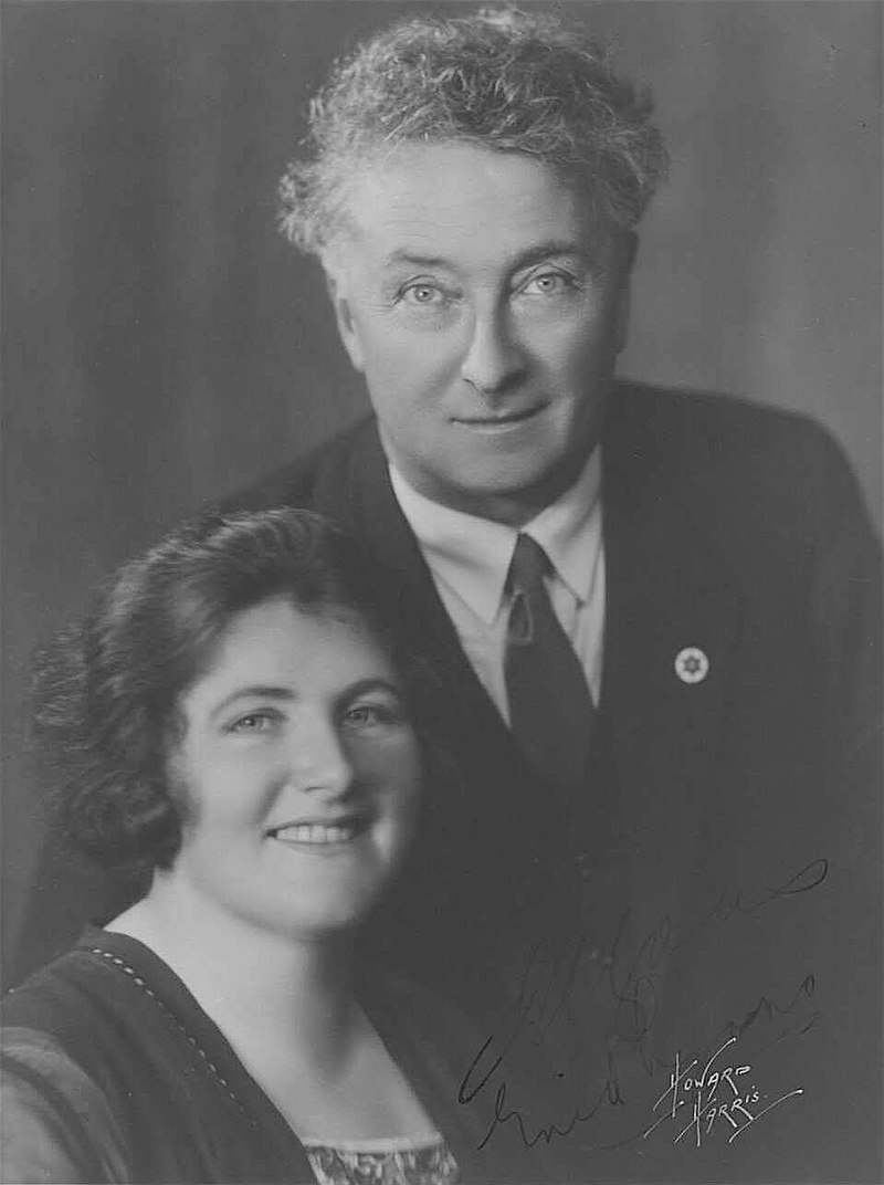
And for something completely different, you may be interested to know that Smithton was also the birthplace of Dame Enid Lyons, wife of the one time Prime Minister of Australia, and the first woman to be elected to the House of Reps. Now there's a 'local girl made good' if ever there was one!

Now back to the present and our tour, and given its prominent position in the town, I've begun with a look upstream along Duck River from a point where we can see a few of the local fishing cutters alongside a small wharf (with seafood factory behind them) and the road bridge over which we had travelled (several times by now).

As you would expect, the locals here are right into fishing, and a very good small boat ramp caters to their needs.

On the opposite bank a number of boat sheds and small marinas provide marine services to boat owners, both professional and amateur.

A short distance downstream from the boat ramp, locals and visitors alike can enjoy a stroll along the river bank on a well constructed

formal walking trail which includes gym stations and public picnic areas.

This entire area is a haven for water birds of all descriptions, (many of which are identified and described on a series of information boards along the walkway),

and these attract some serious photographers (apart from yours truly, that is). Can you just imagine me lugging all this through the streets of town!

As we wandered back along the road, I did snap a couple of local homes,

houses which indicated to us that we were in the 'better' end of town,
but then, there is always someone who has to be completely different!

The elevated main CBD of the town is functional but unremarkable. I began a quick flit through this area at the intersection of Emmett and King Streets,

where this particular view caught my attention....two houses of worship which could not be more different in style and construction.

where this particular view caught my attention....two houses of worship which could not be more different in style and construction.

A little further east up King Street took me past a charming old Smithton cottage, where the front wall served to demonstrate just how steep this road is.

I was actually en route to check out the local Memorial park where, apart from the almost obligatory 'Lone Pine tree',

I came across something I'd never seen before.......a triangular commemorative monument.

Emmett Street is home to the main cluster of commercial businesses in Smithton,

where I soon discovered there is a penchant for mural decoration such as displayed here at this cafe

and on a nearby wall. This all added a touch of colour.

CBD colour was also to be found at each of the major intersections along Emmett Street, in the form of flower beds in the roundabouts and flags fluttering, as seen here at Smith Street.

Smith street is also the location of the decidedly art deco building which is home to the Smithton Club. Unfortunately this was closed at the time I wandered past, so I am unable to comment on the interior, but the street frontage was pretty impressive, if size counts for anything.
A little further to the south of the Smith Street intersection is one of Smithton's older buildings, one of some historical significance, in the commercial sense at least.

The Duck River butter factory, circa 1906, is now obviously and sadly suffering from the ravages of age and neglect, but this belies its past. Its development stands testament to the success of the local dairy industry and, at the peak of its production in the 1950's, this factory was the largest butter producer in Australia, production which has now been moved elsewhere.


Looking west down Gibson Street the sprawl of the McCain factory is more evident than it is from most parts of the town, apart from the steam and smoke that is, which rise above the town buildings constantly, and can be seen from all points. The grey building on the far corner was of interest to us.

It was the rear of the surprisingly large local RSL building,

where, as is our custom, we popped in for a quick drink and a chat with a most welcoming group of locals in the spacious and well appointed bar room.

Let me conclude this brief town toddle with an equally brief return to the river, where as I walked down towards what I thought was a riverside park, I passed this assembly of hitched caravans. "Odd spot for a social gathering", I thought. And then the reason for this congregation became clear....this was the place in the 'RV Friendly Town' where those in need can refill their water tanks.

The Smithton riverside park, like so much else throughout the State at this time, was looking a bit brown and bare,

but the numerous trees did at least provide some greenery and shade for the picnic and BBQ area.
The riparian lawns were equally dessicated, and, as is obvious, the tide was falling in Duck River at the time of this visit. The decks of the craft at the seafood factory mooring where well below the level of the pavement.


And speaking of the bridge, I did take this opportunity to utilise the pedestrian crossing and to take this downstream shot.

And to complete this different picture of Duck River, this is what the marina fingers on the western bank look like as the ebb tide drains the waters off into Bass Strait.

Now I've not posted a photo of any of the local flora for some time, so shall finish this Smithton missive with a fine example of a tree of which we were about to see much more. You may recall I did previously include one which we found near the Burnie docks, and it was not until we reached Smithton that I came to realise that the stunning spectacle presented by these trees was commonplace in this part of Tasmania.
And they are not even locals! By the time we reached Stanley in a few days' time, I was over my ignorance. Enquiries with a chap there revealed that these are trees native to our neighbours across the Tasman. The Kiwis know them as 'Pohutukawa'....we Aussies have simplified the name considerably. Here in Tasmania these magnificent blooming trees are called New Zealand Xmas trees. That's much easier to say and you will see more of them!
But not immediately. In my next we take to the road yet again to visit the village of Arthur River where the seas of the Southern Ocean thunder onto the west Tasmanian coast and another charming river meets the sea.
No comments:
Post a Comment