Queenstown......the Tasmanian town which conjures up visions of the moonscape left by massive mining operations over many years. Liz had seen it all before. I was excited about the prospect in the same way I relish travelling across the Nullarbor or the Hay Plains where the oft barren, seemingly endless flat plains are, for me, fascinating in their 'nothingness' (bad word...hope you get the gist!)
As it turned out Liz was amazed and I was just a little disappointed.....re-vegetation has now covered much of the scarred and barren earth around the town, but there was still enough of the old landscape left to ensure that Queenstown remains unique on the Tassie touring map.

But enough of this preemptive prattle.....we have to first get there. And to do that, our immediate mission in life on rising at Derwent Bridge was to thaw out, and that included cajoling the Ship's Cat out from under his blanket. As I said in my last, this form of slumber was unprecedented as far as Max was concerned.
I have to admit that I snuck out from under the covers just long enough to hit the diesel heater start button before returning to the comfort of the cot until the van temperature had risen from the overnight low of -3 to something approaching livable conditions.
Even then I creaked about a bit until the internal warmth of hot coffee (I've never before been tempted to lace my morning cuppa, but the urge was strong today) and the heat blasting from our marvellous and highly efficient heater did the trick and my joints all moved without too much protest.

The clearing skies of the morning revealed the popularity of this pub as a resting place, situated as it is almost halfway between Hobart and Strahan.

There were no marked sites now unoccupied, and many late comers had just propped where they landed. Strangely enough there was a dearth of general movement in the camp as we made ready to leave.
We were about to embark on the trip which is described as the 'highway with ninety-nine bends'. This is actually not true......my trusty navigator gave up when the count reached one hundred and fifty.
As this excellent government produced tourist map shows (apologies for the fuzzy reproduction....an inescapable product of enlargement) the route from Derwent Bridge to Queenstown virtually bisects the great expanses of Tasmania's western wilderness areas,
As this excellent government produced tourist map shows (apologies for the fuzzy reproduction....an inescapable product of enlargement) the route from Derwent Bridge to Queenstown virtually bisects the great expanses of Tasmania's western wilderness areas,

with the Cradle Mountain - Lake St Clair National Park to the north and that of the Franklin - Gordon south of the highway.
One glance at this offering from Google Earth was enough to convince me that today's
One glance at this offering from Google Earth was enough to convince me that today's

journey would be one of constant mountain scenery with the possible odd pocket of flat or marshy land just for a change.


How true this proved to be. I recognise that there are just so many highway bends, mountain views and thick forest scenes which can be included in an offering such as this before they become stultifying boring, so I've again wielded the editor's blue pen with alacrity in an effort to reduce the innumerable highway shots for today to a representative few. Once Liz gets the photographic bit between her teeth from her co-pilot's seat there is no stopping her!
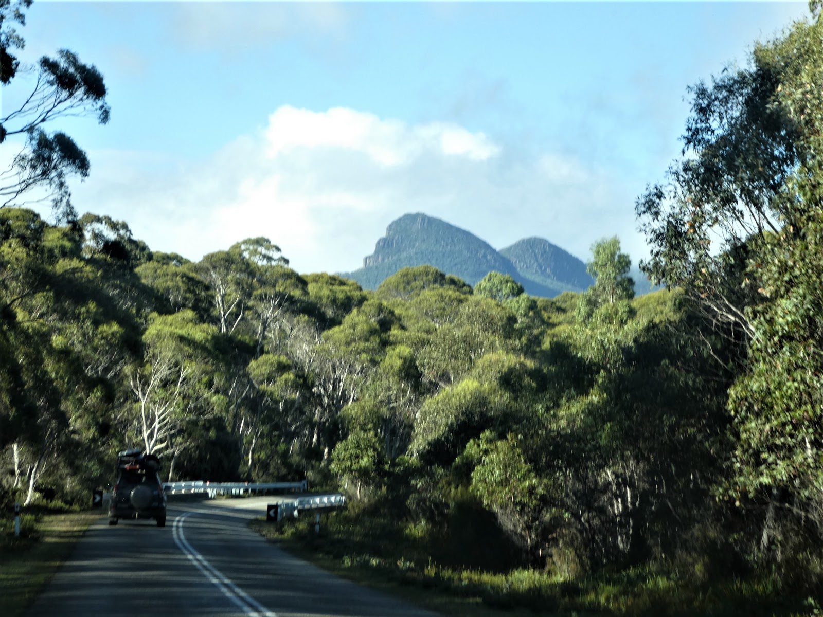
Despite the challenges of this drive, or more to the point, because of them, this is one which should not be missed by any visiting the Apple Isle. We were no more than a few kilometres out of Derwent Bridge when forests and peaks like these continued to fill our forward vision.

As I had anticipated, some of the road took us past relatively flat and open grasslands (often swampy) but these stretches were few and far between.
We were delighted that there were some significant patches of blue sky above us and that the sunlight was typically Tasmanian bright.

One sight we could well have done without was that of this poor old 'muddlehead', a wombat which didn't make it to the other side of the road. Liz had often remarked that unlike her previous visits, the highways were almost completely devoid of road kill, which had usually been Tassie Devils. This hefty wombat, sadly prostrate in his last resting place, came as a real surprise...so much so that I just managed to avoid doing more damage.

We were still toddling along across a less than challenging section of the highway, but this was all about to end.


We were still toddling along across a less than challenging section of the highway, but this was all about to end.

This was an all too familiar roadside warning sign. I should comment here that by now we had well and truly learnt that in Tasmania these signs mean exactly what they say.

The promise of a lookout view out across the King George Range

had me pressing a little more firmly on the brake pedal than might have otherwise been the case as we continued on down the slope,

and although I did manage to find a safe lay-by area and come to a complete stop, the trees immediately below the vantage point had sadly obscured most of what should have been a spectacular view.

By now the day was warming, but not much, and needless to say we did not spend long outdoors at the Surprise Valley lookout before scurrying back to the closeted comfort of the Cruiser cabin!

This typical tunnel of tall timber

brought us to our first river crossing for the day. I had never heard of the Navarre River before, but that is not surprising.
This entire area is a mass of rivers and streams, some more famous than others as we were to find later.

Distant tree clad ranges were a constant throughout this trip

as was the ever changing topography

and the never ending bends

some of which provided views which were like looking down the lens of the camera to the rugged ridges in the far distance.

At one point the landscape altered dramatically where the starkly bare trunks and limbs of these roadside trees bore all the signs of a serious bush fire.

I mentioned earlier that some of the rivers in this area were more famous than others, and just beyond the fire razed stretch of the A10 we came to one of them, the Franklin River. Who could forget the protests that the proposed damming of this wilderness waterway sparked.

I'm not quite sure what we expected to see as we crossed this stream of such previous significance, but frankly it looked like so many others we had come across.

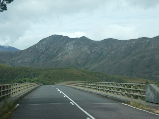
One last dip and bend

had us on the approach to the Bradshaw Bridge. We were about to cross the narrows of the beautiful Lake Burbury, bordered on its far side by a granite massif of awesome proportions.
By now we were on the cusp of the final run into Queenstown (when things get really exciting!) and I've decided to bring you another Google Earth view to put all this into some perspective because

I have found it impossible to do so otherwise. The bridge we were about to cross is the straight section of the highway at the very bottom of the map, directly above the left hand end of the 5 km scale marker. Lake Burbury is a huge expanse of water.....this is only its northern section.
Two more things I would point out are firstly the way in which the highway past the lake squeezes along between the water and the steep mountain ridge we had just seen in front of us, and the second is the colour of the the mountains and hills around Gormanston and through to Queenstown.

So let's push on across the bridge
from which we had our first close look at the southern section of the lake which is one of Queenstown's playgrounds and which we would return to explore in more detail later.

Once across the narrow neck which joins the two sections of the lake, we swept around its western edge towards the rocky ramparts ahead.

These were impressive lumps of granite, similar to much of what we had seen in the Strathgordon area.

As they hemmed the road closer and closer to the edge of the lake, Liz did her best to capture the towering presence of these ancient ranges....with a less than successful outcome I'm afraid, but hopefully the top of our CB aerial gives some idea.

Past the pinch, the last of the lakeside curves took us beyond the water

and on to our first glimpse of the barren hillsides of the old mining areas on the approach to Gormanston.

For me, this all just got better and better

as every bend in the road opened another visual page in the history of mining in and around Queenstown.

We soon found ourselves passing through the old mining hamlet of Gormanston, where the hauntingly grey walls of this once impressive but now long derelict cafe spoke sadly of busier times.
This was one of the areas first mined around Queenstown, a district we would revisit during our stay on a day when we were to learn about ruthlessness, greed and pride.....in spades.

Now for the last leg into 'Queenie'. I knew from all I had read and researched, this was the section of the highway which sends shivers down many spines. I was what I considered to be appropriately prepared, but no amount of pre-planning and imagination can match the real thing, and I confess that as we hauled up out of Gormanston, past the Iron Blow lookout road, I my grips on the steering wheel and the gear shift lever tightened.
The shots through the windscreen did not really do this section justice, so, from here on I've taken the step of combining photos from two different sources, from the Cruiser as we made the journey, and a couple of scenes of the road taken from various vantage points a few days later.

For all the hype, this last leg, whilst demanding, did not prove to be quite as hair raising as I had been led to believe, but on a scale of 1 - 10 for increased pulse rate and intense concentration I would rate this as a 7. For example, if you look closely at the shot above, you will see that at one point about midway, the road 'disappears'. Well not really, it's just that the bend there is so sharp it is hidden by the small rocky outcrop this side of the approaching vehicle.
Let me expand this same view, this time to include Queenstown, nestled as it is in the valley below, to provide another perspective.

It is virtually impossible to present an overview of the tightly twisting ribbon of bitumen which snakes its way steeply down this rocky hillside, where both road and its users cling grimly to the side of the slope.

This was our view, and if the challenges of the road were not enough, this sign told us to 'beware of falling rocks'. Great. Just where the hell do we go to avoid a falling rock? There were but two options....over the edge or over the edge!

Undaunted we pressed on, very slowly,

trying very hard to ignore the sheer and significant drop to our left

whilst at the same time keeping a combined four weather eyes out for oncoming drivers who might be tempted to cut the corners (as a frighteningly large number of them did - invariably in hire cars in which the drivers presented with distinctly non-European visages!)

The replacement of the flimsy looking wire cable fence with a fair dinkum guard rail on the drop side of the road was a welcome sight,

but this did not last for too long before the protection again became 'interesting'. We thought that if we had gone over the edge here we probably would have arrived at our destination.....very quickly, and end over end!

As luck would have it we had either arrived at an unpopular time for tourist traffic, or we just fluked it, but for whatever reason, despite the fact that there were a few vehicles congregated at the lookout point above the town,

we had to share the road with only one or two throughout our entire descent, and to my great relief none of these were trucks. And as you can see here, we were now almost there.

Queenstown, or at least the eastern section of the town, appeared much closer now than it had done when we first caught sight of it.

There was still a bit of work to do

as the Lyell Highway challenged us with 'one last hurrah', but within the next few minutes

and with no more surprises we saw the sign we had been waiting for. The only thing which vexed us now was 'are we really expected to push on the throttle and speed up?' By now we had become quite used to a comfortable 15 - 20 kph!
Despite my best efforts I am afraid the photos still don't really convey the challenges of this part of the A10, but equally I must comment that I found this much feared descent into Queenstown only a little more demanding that quite a number of other sections of Tasmanian mountain highways.

Nevertheless, it did feel almost odd to be cruising sedately down a 'normal' small town street. Now The Navigator had to concentrate on the next matter at hand...finding our park.

This did not prove to be difficult. The main highway brought us in to this junction from where we could already see the town railway station.

And as we turned right to head down Driffield Street we had our first sighting of what are probably the two most well known buildings in town from the tourist point of view....the Empire Hotel and the Wilderness Railway Station. We were to see much more of both in the coming days.

Our chosen caravan park was at the far south-western end of the town. Not that there was much choice...it is the only one here! To reach it we had to cross the Queen River,

an interestingly coloured brook,

and make our way along Urquart Street

which in turn took us into Grafton Street and the entrance to our new home for eight days, the Queenstown Cabin and Caravan Park.

We had heard that this park was under new management (which, from various comments, was apparently a blessing), and I have to say right from the outset, Jac and Andy Starr could not have been more welcoming hosts.

After completing the normal formalities at the office,

we were directed down the driveway to a large site at the far end of the park under the watchful eye of the barren orange top of Mount Owen.

To get there we passed a number of the park drive-thru sites. We had considered one of these, but chose the alternative on the advice of the park owners.

Getting on was a doddle, something for which I was more than grateful after the events of the past hour or so. We were soon well tucked up behind the lovely screen of shrubs and trees which were a feature of this excellent site.
At this point I should make some observations about the surface. As is evident, it was all gravel, and quite course gravel at that, a feature which normally would leave me a little less than entirely impressed, but here in Queenstown it just seemed to fit with all we were seeing around us.
As you will see when we 'do the tour' Jac and Andy have been hard at work with planter boxes of shrubs between sites and are nurturing other ferns and flowers which do much to soften the otherwise somewhat harsh appearance of this park.
The ground here was rock hard and we had no sooner unhitched when Andy appeared with a heavy duty impact drill and long masonry bit in hand...exactly what I needed. I actually carry this kit, but on this occasion did not have to dive into the equipment drawers and drag it all out.

So after a little bit of site mining, all the necessary pegs were well and truly in place and our awning and end shade cloth walls were firmly anchored.

As this angle shows, we were delightfully screened from our sole neighbouring site and with only the park roadway on the other side, we could not have been happier.
You must forgive me it I wax lyrical about this park. We just loved it here. Apart from the friendliness of the owners and the 'elbow room' of our site, everything we needed was close at hand and of a good standard. Time for a tour.

As the title announces, this park does provide a number of modest cabins which were well occupied during our stay, in the main by families enjoying the summer school holidays in the west.

One of the planter boxes here was even sporting one of my favourite shrubs, a hydrangea in full bloom.

Behind the row of cabins the park camping area along the back fence was equally well patronised, although here most groups stayed only one or two nights.

This photo shows that we did not have far to go to get to the amenities block (that's the back of the Cruiser at left of shot). The covered area immediately behind the big Maui

housed the park BBQ area where the usual flat plate was augmented by a large hooded BBQ and wok burner, all that was needed for a serious roast, a fine barbecue or a bit of a stir fry.

At the rear of the building this fern lined pathway took punters to

the well equipped laundry, complete with an iron on hand (this is unusual!)

and the ablutions, where, apart from being kept spotlessly clean, the owners provide another lovely touch. Note the two baskets at the far end of the sinks. In one were clean bathmat towels.....obviously the other was for those which had been used. I know it seems a little thing, and indeed it does make extra work for the park managers, but considerations like this are really appreciated, particularly when the floor is highly likely to be bloody chilly underfoot.

The roadway in front of the head gave access to the drive-thru sites and others between the planter boxes, and as is the case everywhere in Queenstown, steep hills were not too far away.

Now I haven't forgotten the camp kitchen, to which access was gained through the white door at the far end of the amenities building. I have merely save the best till last!

When I first poked my nose in here I could not believe it. For what is a relatively small park, the amenity here was extraordinary......a couple of dining tables, a bar table and high chairs for happy hour groups,

a lounge and comfortable leather arm chairs, a pot belly wood fire in the corner and a large, wall mounted TV (very well used during our stay by a fellow South Australian who was glued to the Australian Open tennis).

To top all this off, the range of kitchen utensils and the cooking facilities was first class.

There was even a set of wine glasses on the crockery shelves.
Nothing here was remarkably 'flash'.....it was just homely, functional and welcoming. And as I said, we have been in plenty of much larger parks where the equivalent facilities would not come within cooee of these.
This was indicative of the whole set up here, and it was ours for the unbelievably low price of just over $23 a night (with our discount).
We had been tossing up about the length of our stay. A move on to Strahan was an option, but once we had established ourselves here in Queenstown, and discovered what was on offer, we decided that we would be nuts to do other than make this our base from which to roam around this part of the Island.


This worked for Max. He is always happy when I set up the cooking table. It doubles as his 'safe' spot from where he can keep a beady eye on the passing parade without being seen (he thinks!)
And 'Chef Pierre' was pretty happy with the set up as well. Nothing like a most welcome balmy Queenstown evening to inspire the production of a dish of fettuccine with a creamy rose tuna sauce!
We both felt completely at home in Queenstown. I was disappointed that much of the 'moonscape' I had been anticipating was now covered with greenery, but there were still enough bare, yellow and orange coloured hills around the town to confirm we were in a very different place.
We had much to do here, and two of these plans included formal tours, something we normally try to avoid. But all we had been told and researched indicated that a trip on the Wilderness Railway and a Gordon River cruise out of Strahan were absolute 'musts'.
Then there were the Nelson Falls to visit, the Iron Blow lookout, the camp grounds of Lake Burbury not to mention the towns of Queenie itself and neighbouring Strahan and Zeehan. We were in for a busy week.

some of which provided views which were like looking down the lens of the camera to the rugged ridges in the far distance.

At one point the landscape altered dramatically where the starkly bare trunks and limbs of these roadside trees bore all the signs of a serious bush fire.

I mentioned earlier that some of the rivers in this area were more famous than others, and just beyond the fire razed stretch of the A10 we came to one of them, the Franklin River. Who could forget the protests that the proposed damming of this wilderness waterway sparked.

I'm not quite sure what we expected to see as we crossed this stream of such previous significance, but frankly it looked like so many others we had come across.

One last dip and bend

had us on the approach to the Bradshaw Bridge. We were about to cross the narrows of the beautiful Lake Burbury, bordered on its far side by a granite massif of awesome proportions.
By now we were on the cusp of the final run into Queenstown (when things get really exciting!) and I've decided to bring you another Google Earth view to put all this into some perspective because

I have found it impossible to do so otherwise. The bridge we were about to cross is the straight section of the highway at the very bottom of the map, directly above the left hand end of the 5 km scale marker. Lake Burbury is a huge expanse of water.....this is only its northern section.
Two more things I would point out are firstly the way in which the highway past the lake squeezes along between the water and the steep mountain ridge we had just seen in front of us, and the second is the colour of the the mountains and hills around Gormanston and through to Queenstown.


So let's push on across the bridge
from which we had our first close look at the southern section of the lake which is one of Queenstown's playgrounds and which we would return to explore in more detail later.

Once across the narrow neck which joins the two sections of the lake, we swept around its western edge towards the rocky ramparts ahead.

These were impressive lumps of granite, similar to much of what we had seen in the Strathgordon area.

As they hemmed the road closer and closer to the edge of the lake, Liz did her best to capture the towering presence of these ancient ranges....with a less than successful outcome I'm afraid, but hopefully the top of our CB aerial gives some idea.

Past the pinch, the last of the lakeside curves took us beyond the water

and on to our first glimpse of the barren hillsides of the old mining areas on the approach to Gormanston.

For me, this all just got better and better

as every bend in the road opened another visual page in the history of mining in and around Queenstown.

We soon found ourselves passing through the old mining hamlet of Gormanston, where the hauntingly grey walls of this once impressive but now long derelict cafe spoke sadly of busier times.
This was one of the areas first mined around Queenstown, a district we would revisit during our stay on a day when we were to learn about ruthlessness, greed and pride.....in spades.

Now for the last leg into 'Queenie'. I knew from all I had read and researched, this was the section of the highway which sends shivers down many spines. I was what I considered to be appropriately prepared, but no amount of pre-planning and imagination can match the real thing, and I confess that as we hauled up out of Gormanston, past the Iron Blow lookout road, I my grips on the steering wheel and the gear shift lever tightened.

For all the hype, this last leg, whilst demanding, did not prove to be quite as hair raising as I had been led to believe, but on a scale of 1 - 10 for increased pulse rate and intense concentration I would rate this as a 7. For example, if you look closely at the shot above, you will see that at one point about midway, the road 'disappears'. Well not really, it's just that the bend there is so sharp it is hidden by the small rocky outcrop this side of the approaching vehicle.
Let me expand this same view, this time to include Queenstown, nestled as it is in the valley below, to provide another perspective.

It is virtually impossible to present an overview of the tightly twisting ribbon of bitumen which snakes its way steeply down this rocky hillside, where both road and its users cling grimly to the side of the slope.

This was our view, and if the challenges of the road were not enough, this sign told us to 'beware of falling rocks'. Great. Just where the hell do we go to avoid a falling rock? There were but two options....over the edge or over the edge!

Undaunted we pressed on, very slowly,

trying very hard to ignore the sheer and significant drop to our left

whilst at the same time keeping a combined four weather eyes out for oncoming drivers who might be tempted to cut the corners (as a frighteningly large number of them did - invariably in hire cars in which the drivers presented with distinctly non-European visages!)

The replacement of the flimsy looking wire cable fence with a fair dinkum guard rail on the drop side of the road was a welcome sight,

but this did not last for too long before the protection again became 'interesting'. We thought that if we had gone over the edge here we probably would have arrived at our destination.....very quickly, and end over end!

As luck would have it we had either arrived at an unpopular time for tourist traffic, or we just fluked it, but for whatever reason, despite the fact that there were a few vehicles congregated at the lookout point above the town,

we had to share the road with only one or two throughout our entire descent, and to my great relief none of these were trucks. And as you can see here, we were now almost there.

Queenstown, or at least the eastern section of the town, appeared much closer now than it had done when we first caught sight of it.

There was still a bit of work to do

as the Lyell Highway challenged us with 'one last hurrah', but within the next few minutes

and with no more surprises we saw the sign we had been waiting for. The only thing which vexed us now was 'are we really expected to push on the throttle and speed up?' By now we had become quite used to a comfortable 15 - 20 kph!
Despite my best efforts I am afraid the photos still don't really convey the challenges of this part of the A10, but equally I must comment that I found this much feared descent into Queenstown only a little more demanding that quite a number of other sections of Tasmanian mountain highways.

Nevertheless, it did feel almost odd to be cruising sedately down a 'normal' small town street. Now The Navigator had to concentrate on the next matter at hand...finding our park.

This did not prove to be difficult. The main highway brought us in to this junction from where we could already see the town railway station.

And as we turned right to head down Driffield Street we had our first sighting of what are probably the two most well known buildings in town from the tourist point of view....the Empire Hotel and the Wilderness Railway Station. We were to see much more of both in the coming days.

Our chosen caravan park was at the far south-western end of the town. Not that there was much choice...it is the only one here! To reach it we had to cross the Queen River,

an interestingly coloured brook,

and make our way along Urquart Street

which in turn took us into Grafton Street and the entrance to our new home for eight days, the Queenstown Cabin and Caravan Park.

We had heard that this park was under new management (which, from various comments, was apparently a blessing), and I have to say right from the outset, Jac and Andy Starr could not have been more welcoming hosts.

After completing the normal formalities at the office,

we were directed down the driveway to a large site at the far end of the park under the watchful eye of the barren orange top of Mount Owen.

To get there we passed a number of the park drive-thru sites. We had considered one of these, but chose the alternative on the advice of the park owners.

Getting on was a doddle, something for which I was more than grateful after the events of the past hour or so. We were soon well tucked up behind the lovely screen of shrubs and trees which were a feature of this excellent site.
At this point I should make some observations about the surface. As is evident, it was all gravel, and quite course gravel at that, a feature which normally would leave me a little less than entirely impressed, but here in Queenstown it just seemed to fit with all we were seeing around us.
As you will see when we 'do the tour' Jac and Andy have been hard at work with planter boxes of shrubs between sites and are nurturing other ferns and flowers which do much to soften the otherwise somewhat harsh appearance of this park.
The ground here was rock hard and we had no sooner unhitched when Andy appeared with a heavy duty impact drill and long masonry bit in hand...exactly what I needed. I actually carry this kit, but on this occasion did not have to dive into the equipment drawers and drag it all out.

So after a little bit of site mining, all the necessary pegs were well and truly in place and our awning and end shade cloth walls were firmly anchored.

As this angle shows, we were delightfully screened from our sole neighbouring site and with only the park roadway on the other side, we could not have been happier.
You must forgive me it I wax lyrical about this park. We just loved it here. Apart from the friendliness of the owners and the 'elbow room' of our site, everything we needed was close at hand and of a good standard. Time for a tour.

As the title announces, this park does provide a number of modest cabins which were well occupied during our stay, in the main by families enjoying the summer school holidays in the west.

One of the planter boxes here was even sporting one of my favourite shrubs, a hydrangea in full bloom.

Behind the row of cabins the park camping area along the back fence was equally well patronised, although here most groups stayed only one or two nights.

This photo shows that we did not have far to go to get to the amenities block (that's the back of the Cruiser at left of shot). The covered area immediately behind the big Maui

housed the park BBQ area where the usual flat plate was augmented by a large hooded BBQ and wok burner, all that was needed for a serious roast, a fine barbecue or a bit of a stir fry.

At the rear of the building this fern lined pathway took punters to

the well equipped laundry, complete with an iron on hand (this is unusual!)

and the ablutions, where, apart from being kept spotlessly clean, the owners provide another lovely touch. Note the two baskets at the far end of the sinks. In one were clean bathmat towels.....obviously the other was for those which had been used. I know it seems a little thing, and indeed it does make extra work for the park managers, but considerations like this are really appreciated, particularly when the floor is highly likely to be bloody chilly underfoot.

The roadway in front of the head gave access to the drive-thru sites and others between the planter boxes, and as is the case everywhere in Queenstown, steep hills were not too far away.

Now I haven't forgotten the camp kitchen, to which access was gained through the white door at the far end of the amenities building. I have merely save the best till last!

When I first poked my nose in here I could not believe it. For what is a relatively small park, the amenity here was extraordinary......a couple of dining tables, a bar table and high chairs for happy hour groups,

a lounge and comfortable leather arm chairs, a pot belly wood fire in the corner and a large, wall mounted TV (very well used during our stay by a fellow South Australian who was glued to the Australian Open tennis).

To top all this off, the range of kitchen utensils and the cooking facilities was first class.

There was even a set of wine glasses on the crockery shelves.
Nothing here was remarkably 'flash'.....it was just homely, functional and welcoming. And as I said, we have been in plenty of much larger parks where the equivalent facilities would not come within cooee of these.
This was indicative of the whole set up here, and it was ours for the unbelievably low price of just over $23 a night (with our discount).
We had been tossing up about the length of our stay. A move on to Strahan was an option, but once we had established ourselves here in Queenstown, and discovered what was on offer, we decided that we would be nuts to do other than make this our base from which to roam around this part of the Island.


This worked for Max. He is always happy when I set up the cooking table. It doubles as his 'safe' spot from where he can keep a beady eye on the passing parade without being seen (he thinks!)
And 'Chef Pierre' was pretty happy with the set up as well. Nothing like a most welcome balmy Queenstown evening to inspire the production of a dish of fettuccine with a creamy rose tuna sauce!
We both felt completely at home in Queenstown. I was disappointed that much of the 'moonscape' I had been anticipating was now covered with greenery, but there were still enough bare, yellow and orange coloured hills around the town to confirm we were in a very different place.
We had much to do here, and two of these plans included formal tours, something we normally try to avoid. But all we had been told and researched indicated that a trip on the Wilderness Railway and a Gordon River cruise out of Strahan were absolute 'musts'.
Then there were the Nelson Falls to visit, the Iron Blow lookout, the camp grounds of Lake Burbury not to mention the towns of Queenie itself and neighbouring Strahan and Zeehan. We were in for a busy week.
No comments:
Post a Comment