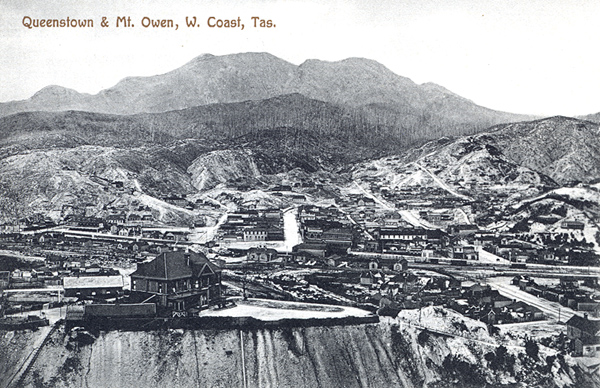
Let's begin on a high note, well a high spot at least. One of the best overviews of Queenstown possible is the reward for a struggle up the pathway and stairs of the hill known as Spion Kop, a name which commemorates a famous battle of the Boer War and which was bestowed on this prominent landmark by soldiers returning from that conflict.
Before I go further, let me present a quick overview of Queenstown from Google Earth with some of my very ineptly added arrows. As you can see from this, Queenie is an elongated township, squeezed along the Queen River valley between the two high ridges either side. Indeed in many of the photos I have and shall be presenting, the surrounding hills and peaks are ever present. The incredibly orange slash of the Queen River is obvious.
Before I go further, let me present a quick overview of Queenstown from Google Earth with some of my very ineptly added arrows. As you can see from this, Queenie is an elongated township, squeezed along the Queen River valley between the two high ridges either side. Indeed in many of the photos I have and shall be presenting, the surrounding hills and peaks are ever present. The incredibly orange slash of the Queen River is obvious.

Now to the arrows, beginning at the top. The red dart points to the position of the current copper mine whilst the blue shows the peak of Spion Kop (below which you can see a white patch....the town oval...more later!).
The white arrow indicates the position of the railway station and lower part of the CBD and the yellow the location of our caravan park.

I guess there is no point in being surrounded by hills if advantage is not taken of them. This is certainly not the case in Queenstown where the lookout rises directly over the northern end of Driffield Street.

A car park half way up the hill provided a starting point, but from then on it was shank's pony to the top, initially up a cement pathway

which culminated in a flight of rather primitive stairs at the upper end.

It was a bit of a slog, but well worth the effort. From here we could see out past the small field gun top the hill over the western side of the CBD (the gleaming white roof mid shot is the hospital).

and by panning just slightly to the right, we had this marvellous view of 'tourist' Queenstown, including the magnificent Empire Hotel and the Wilderness Railway station, both of which were clearly prominent.

As we swept our view yet further to the right, I was able to pick out the grand Queen Anne style 'house on the hill'. 'Pengahana' is now a very up-market B&B, but as you might expect there is story here, so let me briefly digress.
In doing so, I've relied on the most informative Penghana website for the following text and photos:

"Penghana was built in 1898 for the General Manager of the Mount Lyell Mining and Railway Company, Mr Robert Sticht, after fire destroyed the “tent” styled settlement which had grown up in the shadow of the progressive smelters.

Back to the present..........

.....and now we come to the town oval, a playing field unlike any other in Tasmania certainly, and as far as I am aware, nowhere else in the entire world is there a silica gravel playing field (no-on else would be silly enough??)

This is as good a time as any to bring you the story of this extraordinary field of sporting conflict. Information plaques at its entrance provided us with the history.

This same board went on to note what I thought was the 'bleeding' obvious!
By all accounts the contests here were fierce. At the end of one early match, decisions by the umpire had proved to be so unpopular with the local supporters that they set his horse free and it galloped out of town. The poor unfortunate official then had to walk home......to Gormanston!
Over the past 120 years the oval has been mainly used for Aussie Rules, but was also the venue for horse trotting during the early 1900's. Today 'The Gravel' is home to the Western Tassie Cricket Association and more latterly has been used for school athletic carnivals.
But no matter the sport or other activity, one rule prevails here......do not bloody well fall over or you will be well bloodied!
As I expected it might, 'Aussie Towns' had a delightfully pithy comment about this oddest of ovals which I've included as the last word on 'The Gravel':
"They play Australian Rules Football in western Tasmania and as a study in sheer, foolhardy "hard man" bravery, to play a game on Queenstown's gravel oval has got to be the height of stupidity or a crazy brave preparedness to come off grazed and bleeding. It is claimed the oval was created because a grass oval, given the area's huge rainfall, would have always been nothing more than mud. With mud you slip and slide, with gravel you just get flesh ripped off you. Not surprisingly it has terrified visiting teams for nearly a century."

Beyond the oval, our perch provided yet another view of the Mount Lyell mine, its surrounds and the harsh ridge of the ranges beyond.

In the opposite direction, on the hilltop leading up to Mount Owen, I spied this one lone tree which was quite evidently determined to surge well ahead of its fellows in the re-vegetation stakes.

As I said before, this climb was worth the effort. Then of course, we had to get back down, but even this presented more typical Queenstown views where harsh denuded mountain peaks glower over the town.
Well, now that we were warm, it was time for our usual town stroll, and at this point I must confess that the photos are something of a composite collection pulled together over a couple of sorties.

In fact, I have decided to start back at our park and make our way pictorially into the CBD from there, a jaunt which took us initially along Urquhart Street where we passed several neat Queenstown cottages,

and others which may well have belonged to those who were 'just hanging around'.

Crossing the Queen River bridge

brought us into the southern end of Driffield Street where a spot of exercise lay before us.

The Wilderness Railway line parallels the street along this stretch and our stroll north-west took us firstly past the railway works shed which arched over the lines

and a little further on we came to the first of two main parks on this street.

Here this quite evocative fountain statue, complete with miners' pick,

and this series of small individual monuments in the surrounding circular garden,

serve to remind all and sundry of that dreadful day in 1912.

On the opposite side of the road we found the first of the two operational pubs in the town of which we were aware.

The Railway Hotel was a far cry from the Empire (which we'll visit later), but from what we saw it nevertheless attracted a fair bunch of 'regulars'.
Only two pubs in town! What a change this was from the days of yore.
Following the discovery of gold in the area in 1881, many diggers landed at the Strahan Harbour. In an endeavour which stands as a testament to the power of the lure of gold, to reach the area these hardy hopefuls then made the extremely difficult trip up the King River, or even worse, slogged their way up and down the step hills and gullies covered by all but impenetrable scrub.
Claims were pegged out and Queenstown had its genesis in the shanty town of Penghana in the Queen River Valley. After this was burnt down in 1896, those who stayed moved further along the Queen River to establish what was now renamed as Queenstown.
With the later development of copper mining, and the establishment of the rail link to Strahan, Queenstown boomed.

And one of the focal points of that industry was now dominating our view, the long and very well maintained Western Wilderness Railway Station. I'll have more to say about this when I present the blog of our trip on this extraordinary railway.

Beyond the station building a short park

connects it to another of the town's major attractions. These stone walls marked the entrance to the renowned Miners' Siding sculptures.


In this series of large and small works, the artist Stephen Walker has depicted significant and traditional events in the 100 year history of the Lyell District. This remarkable work and the re-opening of the railway between Queenstown and Strahan in 2003, have both contributed significantly in drawing tourists to this area.
This is the reverse view of the main sculpture looking back towards the railway station and the front of 'The Empire'.

Beyond this, the large raised shelter

houses a piece of mine machinery of the more modern era.

The two are connected by a long flowing water feature

in which a series of small castings show various scenes of local life, such as this one which celebrates a picnic on the King River.

The opening up of the west coast to motor vehicles is depicted in this offering

whilst this notes the significance of off shore fishing out of Strahan Harbour.
This really is something to see, and has been very strategically sited at what is both the tourist heart of the town and the entrance to Orr Street, the main commercial thoroughfare of Queenie.

Just beyond Miners' Siding, at the far end of Driffield Street, we could see the last of the two major structures in this part of the town, the Galley Museum and the old Evans Store building.
What is now the museum building (which we probably should have visited, but for some reason did not) has had an interesting and not atypical history. It began life as the Imperial Hotel in 1898 (wasn't the importance then of the ties to the Mother Country reflected in the names of that era....Imperial Hotel, Empire Hotel, Queenstown itself and so on). After the taps ran dry at the bar, this building was then converted to a hospital and later into miners' accommodation before being refurbished and re-opened in its present format.

Whilst no longer a general store as it was when it opened, this building has a real tie with Queenstown, not so much for its current function, but its name.
In another oddity we had been finding throughout Tasmania, here in Queenstown there were two supermarkets, both in Orr Street and both belonging to, and run by, the Evans family. If ever there was a vote of confidence lodged for the promise of the future of Queenstown, the Evans family have provided it is spades.......the current 'Evanses' are members of the fourth generation to maintain the services of a general store/supermarket in the town.

The town War Memorial stands in a small open space opposite Miners' Siding,

within a stone's throw of one of one of Queenstown's most recognised buildings, the opulent looking Empire Hotel which dominates the junction of Driffield and Orr Streets. We were to return here later for a much better look at the incredible interior of this magnificent watering hole.

Under the ever present backdrop of the scarred and barren crest of Mount Owen, shrouded today as it often was in low cloud, Orr Street was also to provide us with one or two reminders of the heady days of the town with the 'richest copper mine in the world'.

As we ventured more or less east up the gentle incline of this main shopping precinct, this mural bounding one side of a small paved square was unavoidable, but annoyingly I was unable to discover exactly what this was all about, other than the obvious.

The large and almost incongruously 'outback' looking Mount Lyell Motel took up a fair chunk of the corner opposite the square.

We did not have to walk too far before another of the fourteen town pubs of the past featured large in the streetscape.

Unlike the Empire, and the old Imperial, now the town museum, the Hunters Hotel was in a state of obvious disrepair, but I believe from what I was later told, that steps were afoot to bring this grand old lady with her frilly lace balcony back to her former glory. Let's hope this was true.

A mere few paces further on, at the junction of Orr and Stitch Streets, the stunning facade of the Queenstown Post Office showed just what could be done to preserve the town's history beautifully.

Looking in a southerly direction along Stitch Street we could see the flag flying above the Queenstown Police Station with yet another reminder of just how hilly this town is beyond the narrow confines of the Queen River Valley floor. The homes on the hill were just typical of Queenie.

And speaking of homes beetling up a slope, here, looking in the opposite direction along Stitch Street we had another example of both hillside houses and the startling contrast between the old and the new which was also not an uncommon sight here. This suggested to us that there were many younger folk who were prepared to build here and make this town their home.

At about this point I could not resist turning around for another shot of the Post Office, a photo which also shows one of the two Evans stores I spoke of earlier.

And then we came to this oddity. For some reason the owners of this building had decided that the rather imposing facade would look all the better for having the columns decorated with a shiny copper coloured paint. I'll say no more.

I suppose at least the copper columns which were part of the original old front of house have been retained, unlike that of the Gaiety Hall opposite, where for some unknown reason it was decided to plonk this totally unsympathetic front entrance addition right across the original facade. Again, I'll make no further comment.

Another of the town's halls stands right across the road, this time the Lyell District Memorial Hall which was built in the early 30's as the second of Queenstown's acknowledgements of the sacrifices of those who went to war.

One thing which can be said for this town is that it does not want for tourist accommodation. Here, on the corner of Bowes Street the Queenstown Motor Lodge stood ready to welcome guests.

And should any who do take up temporary residence here fall ill, help is not far away in the form of the modern looking West Coast District Hospital all but next door.

With one last snap of some of Orr Street's older but well preserved little shops

and a general shot back down the street from this end of town, it was time for an about turn and a wander into some of the streets running off this central commercial thoroughfare.
It was also time for a quiet libation in two completely different watering holes, and that's exactly what we did, but I'll make that the subject of my next offering.
The white arrow indicates the position of the railway station and lower part of the CBD and the yellow the location of our caravan park.

I guess there is no point in being surrounded by hills if advantage is not taken of them. This is certainly not the case in Queenstown where the lookout rises directly over the northern end of Driffield Street.

A car park half way up the hill provided a starting point, but from then on it was shank's pony to the top, initially up a cement pathway
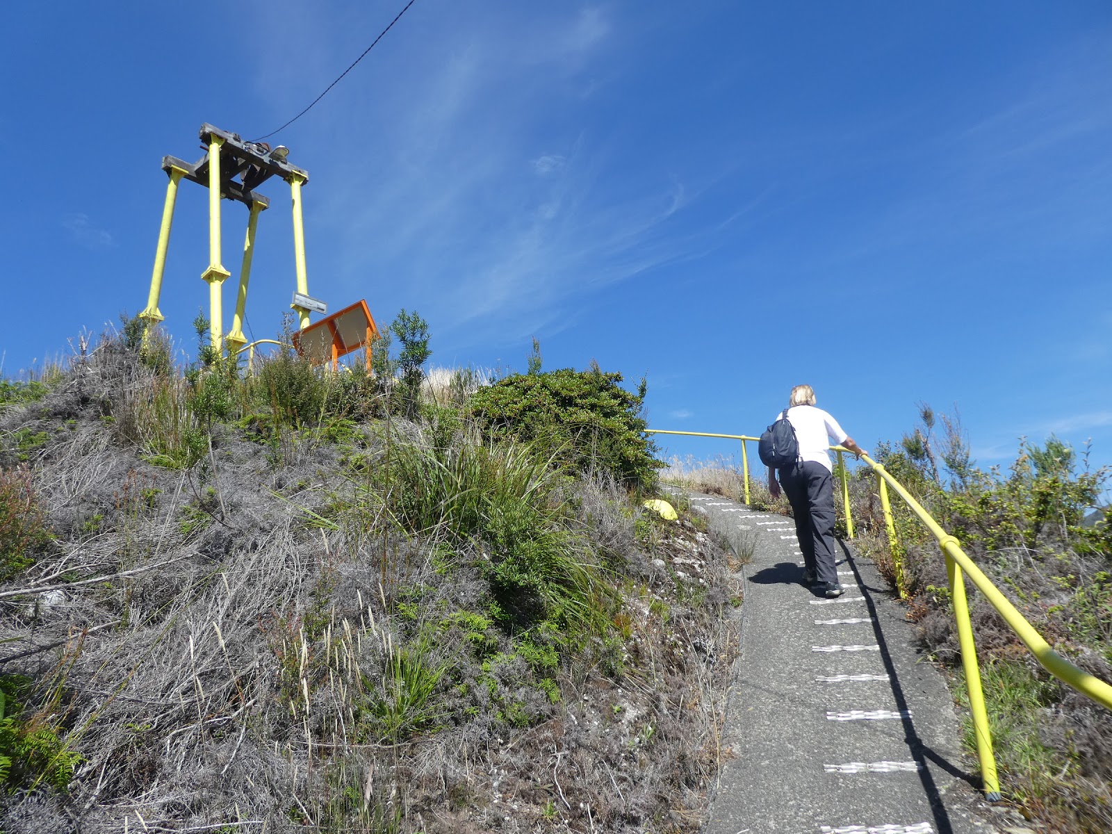
which culminated in a flight of rather primitive stairs at the upper end.

It was a bit of a slog, but well worth the effort. From here we could see out past the small field gun top the hill over the western side of the CBD (the gleaming white roof mid shot is the hospital).

and by panning just slightly to the right, we had this marvellous view of 'tourist' Queenstown, including the magnificent Empire Hotel and the Wilderness Railway station, both of which were clearly prominent.

As we swept our view yet further to the right, I was able to pick out the grand Queen Anne style 'house on the hill'. 'Pengahana' is now a very up-market B&B, but as you might expect there is story here, so let me briefly digress.
In doing so, I've relied on the most informative Penghana website for the following text and photos:

"Penghana was built in 1898 for the General Manager of the Mount Lyell Mining and Railway Company, Mr Robert Sticht, after fire destroyed the “tent” styled settlement which had grown up in the shadow of the progressive smelters.

In the late 1890’s Queenstown’s development of buildings reflected
the enormous wealth associated with the company’s desire for a corporate
identity to project a successful and confident image and inspire
investor confidence.
As Queenstown was a company town and the General Manager was the most powerful person in the town, the general manager’s residence was constructed and positioned to exemplify that."
As Queenstown was a company town and the General Manager was the most powerful person in the town, the general manager’s residence was constructed and positioned to exemplify that."
Back to the present..........

.....and now we come to the town oval, a playing field unlike any other in Tasmania certainly, and as far as I am aware, nowhere else in the entire world is there a silica gravel playing field (no-on else would be silly enough??)

This is as good a time as any to bring you the story of this extraordinary field of sporting conflict. Information plaques at its entrance provided us with the history.

This same board went on to note what I thought was the 'bleeding' obvious!
By all accounts the contests here were fierce. At the end of one early match, decisions by the umpire had proved to be so unpopular with the local supporters that they set his horse free and it galloped out of town. The poor unfortunate official then had to walk home......to Gormanston!
Over the past 120 years the oval has been mainly used for Aussie Rules, but was also the venue for horse trotting during the early 1900's. Today 'The Gravel' is home to the Western Tassie Cricket Association and more latterly has been used for school athletic carnivals.
But no matter the sport or other activity, one rule prevails here......do not bloody well fall over or you will be well bloodied!
"They play Australian Rules Football in western Tasmania and as a study in sheer, foolhardy "hard man" bravery, to play a game on Queenstown's gravel oval has got to be the height of stupidity or a crazy brave preparedness to come off grazed and bleeding. It is claimed the oval was created because a grass oval, given the area's huge rainfall, would have always been nothing more than mud. With mud you slip and slide, with gravel you just get flesh ripped off you. Not surprisingly it has terrified visiting teams for nearly a century."

Beyond the oval, our perch provided yet another view of the Mount Lyell mine, its surrounds and the harsh ridge of the ranges beyond.

In the opposite direction, on the hilltop leading up to Mount Owen, I spied this one lone tree which was quite evidently determined to surge well ahead of its fellows in the re-vegetation stakes.

As I said before, this climb was worth the effort. Then of course, we had to get back down, but even this presented more typical Queenstown views where harsh denuded mountain peaks glower over the town.
Well, now that we were warm, it was time for our usual town stroll, and at this point I must confess that the photos are something of a composite collection pulled together over a couple of sorties.

In fact, I have decided to start back at our park and make our way pictorially into the CBD from there, a jaunt which took us initially along Urquhart Street where we passed several neat Queenstown cottages,

and others which may well have belonged to those who were 'just hanging around'.

Crossing the Queen River bridge

brought us into the southern end of Driffield Street where a spot of exercise lay before us.

The Wilderness Railway line parallels the street along this stretch and our stroll north-west took us firstly past the railway works shed which arched over the lines

and a little further on we came to the first of two main parks on this street.

Here this quite evocative fountain statue, complete with miners' pick,

and this series of small individual monuments in the surrounding circular garden,

serve to remind all and sundry of that dreadful day in 1912.

On the opposite side of the road we found the first of the two operational pubs in the town of which we were aware.

The Railway Hotel was a far cry from the Empire (which we'll visit later), but from what we saw it nevertheless attracted a fair bunch of 'regulars'.
Only two pubs in town! What a change this was from the days of yore.
Following the discovery of gold in the area in 1881, many diggers landed at the Strahan Harbour. In an endeavour which stands as a testament to the power of the lure of gold, to reach the area these hardy hopefuls then made the extremely difficult trip up the King River, or even worse, slogged their way up and down the step hills and gullies covered by all but impenetrable scrub.
Claims were pegged out and Queenstown had its genesis in the shanty town of Penghana in the Queen River Valley. After this was burnt down in 1896, those who stayed moved further along the Queen River to establish what was now renamed as Queenstown.
With the later development of copper mining, and the establishment of the rail link to Strahan, Queenstown boomed.
By 1901, the year the magnificent Empire Hotel was completed, this was Tasmania's third largest town. Its 5000 plus population occupied 1,300 houses, and were served by banks, schools, shops and, of course, several churches (this was Tassie after all).
And just look at the comparative grandeur and dominating position of 'Penghana' in the developing township.
And just look at the comparative grandeur and dominating position of 'Penghana' in the developing township.
It soon gained electric street
lighting, provided by the Company's Lake Margaret power scheme and by now it boasted fourteen pubs......this mining lark is thirsty work!
As we have seen, tree-felling, sulphur and fire denuded the surrounding hills of trees,
giving Queenstown its 'moonscape', but the mines brought prosperity and,
as well, more militant workers than elsewhere in Tasmania, strong
unions, and a close-knit community. Whilst other nearby mining towns established rail links to the north coast, Queenstown remained remote.
As Alison Alexander has noted in her excellent article for the Centre of Tasmanian Historical Studies, "the population rose and fell in succeeding years, as mining's fortunes varied and large machinery gradually displaced manual workers, but Queenstown continued to be a major town. A road linking it to Hobart, the Lyell Highway, was
finally opened in 1932.
From the 1970s the workforce declined, even more
so in the 1990s when the Mount Lyell Company sold the mine, but tourism developed, with visitors drawn to the unearthly landscape."
The town did enjoy a brief boom in the 1980's, when the Crotty and Darwin dams were built and the Lake Burbury hydro scheme came into being.
Whilst it still remains the largest town on the island's west coast, with a current population of about 2,000, that is as much a comment on the size of the others (or lack of it) as anything else. But as we were to see, it does remain home to the area council, the regional hospital, the district police headquarters, and a large court house. Obviously tourism now plays a major role in the local economy.

And one of the focal points of that industry was now dominating our view, the long and very well maintained Western Wilderness Railway Station. I'll have more to say about this when I present the blog of our trip on this extraordinary railway.

Beyond the station building a short park

connects it to another of the town's major attractions. These stone walls marked the entrance to the renowned Miners' Siding sculptures.


In this series of large and small works, the artist Stephen Walker has depicted significant and traditional events in the 100 year history of the Lyell District. This remarkable work and the re-opening of the railway between Queenstown and Strahan in 2003, have both contributed significantly in drawing tourists to this area.
This is the reverse view of the main sculpture looking back towards the railway station and the front of 'The Empire'.

Beyond this, the large raised shelter

houses a piece of mine machinery of the more modern era.

The two are connected by a long flowing water feature

in which a series of small castings show various scenes of local life, such as this one which celebrates a picnic on the King River.

The opening up of the west coast to motor vehicles is depicted in this offering

whilst this notes the significance of off shore fishing out of Strahan Harbour.
This really is something to see, and has been very strategically sited at what is both the tourist heart of the town and the entrance to Orr Street, the main commercial thoroughfare of Queenie.

Just beyond Miners' Siding, at the far end of Driffield Street, we could see the last of the two major structures in this part of the town, the Galley Museum and the old Evans Store building.
What is now the museum building (which we probably should have visited, but for some reason did not) has had an interesting and not atypical history. It began life as the Imperial Hotel in 1898 (wasn't the importance then of the ties to the Mother Country reflected in the names of that era....Imperial Hotel, Empire Hotel, Queenstown itself and so on). After the taps ran dry at the bar, this building was then converted to a hospital and later into miners' accommodation before being refurbished and re-opened in its present format.

Whilst no longer a general store as it was when it opened, this building has a real tie with Queenstown, not so much for its current function, but its name.
In another oddity we had been finding throughout Tasmania, here in Queenstown there were two supermarkets, both in Orr Street and both belonging to, and run by, the Evans family. If ever there was a vote of confidence lodged for the promise of the future of Queenstown, the Evans family have provided it is spades.......the current 'Evanses' are members of the fourth generation to maintain the services of a general store/supermarket in the town.

The town War Memorial stands in a small open space opposite Miners' Siding,

within a stone's throw of one of one of Queenstown's most recognised buildings, the opulent looking Empire Hotel which dominates the junction of Driffield and Orr Streets. We were to return here later for a much better look at the incredible interior of this magnificent watering hole.

Under the ever present backdrop of the scarred and barren crest of Mount Owen, shrouded today as it often was in low cloud, Orr Street was also to provide us with one or two reminders of the heady days of the town with the 'richest copper mine in the world'.

As we ventured more or less east up the gentle incline of this main shopping precinct, this mural bounding one side of a small paved square was unavoidable, but annoyingly I was unable to discover exactly what this was all about, other than the obvious.

The large and almost incongruously 'outback' looking Mount Lyell Motel took up a fair chunk of the corner opposite the square.

We did not have to walk too far before another of the fourteen town pubs of the past featured large in the streetscape.

Unlike the Empire, and the old Imperial, now the town museum, the Hunters Hotel was in a state of obvious disrepair, but I believe from what I was later told, that steps were afoot to bring this grand old lady with her frilly lace balcony back to her former glory. Let's hope this was true.

A mere few paces further on, at the junction of Orr and Stitch Streets, the stunning facade of the Queenstown Post Office showed just what could be done to preserve the town's history beautifully.

Looking in a southerly direction along Stitch Street we could see the flag flying above the Queenstown Police Station with yet another reminder of just how hilly this town is beyond the narrow confines of the Queen River Valley floor. The homes on the hill were just typical of Queenie.

And speaking of homes beetling up a slope, here, looking in the opposite direction along Stitch Street we had another example of both hillside houses and the startling contrast between the old and the new which was also not an uncommon sight here. This suggested to us that there were many younger folk who were prepared to build here and make this town their home.

At about this point I could not resist turning around for another shot of the Post Office, a photo which also shows one of the two Evans stores I spoke of earlier.

And then we came to this oddity. For some reason the owners of this building had decided that the rather imposing facade would look all the better for having the columns decorated with a shiny copper coloured paint. I'll say no more.

I suppose at least the copper columns which were part of the original old front of house have been retained, unlike that of the Gaiety Hall opposite, where for some unknown reason it was decided to plonk this totally unsympathetic front entrance addition right across the original facade. Again, I'll make no further comment.

Another of the town's halls stands right across the road, this time the Lyell District Memorial Hall which was built in the early 30's as the second of Queenstown's acknowledgements of the sacrifices of those who went to war.

One thing which can be said for this town is that it does not want for tourist accommodation. Here, on the corner of Bowes Street the Queenstown Motor Lodge stood ready to welcome guests.

And should any who do take up temporary residence here fall ill, help is not far away in the form of the modern looking West Coast District Hospital all but next door.

With one last snap of some of Orr Street's older but well preserved little shops

and a general shot back down the street from this end of town, it was time for an about turn and a wander into some of the streets running off this central commercial thoroughfare.
It was also time for a quiet libation in two completely different watering holes, and that's exactly what we did, but I'll make that the subject of my next offering.
No comments:
Post a Comment