I must commence this offering with an apology. In my last I made the comment that I had split the presentation of our day trip to Strathgordon and beyond to ensure that each blog would not be too long. Sorry folks, we had just the most interesting day, and despite my good intentions this one grew legs. But dive in, the water's warm!
Strathgordon is known for several things.....the 'town at the end of the road', the 'village that moved', and the home of the Lake Pedder Wilderness Lodge. It was also at the forefront of activity which spawned the Tasmanian protest movement and the birth of the 'Greens'.
Strathgordon is known for several things.....the 'town at the end of the road', the 'village that moved', and the home of the Lake Pedder Wilderness Lodge. It was also at the forefront of activity which spawned the Tasmanian protest movement and the birth of the 'Greens'.
'Discover Tasmania' speaks thus of the town:
"Strathgordon is set deep within the Tasmanian wilderness on the banks of Lake Pedder, surrounded by a spectacular landscape packed with adventure activities, and with a secret history to share. Located on the edge of Tasmania's World Heritage Wilderness Area, Strathgordon is literally the place at the end of the road. From here, civilisation ends and there is only amazing nature to explore. It also sits on the edge of Lake Pedder, Australia's largest freshwater lake and water catchment system."
These comments are echoed on the 'Hobart and Beyond' website:
"If you’re heading to Strathgordon you’re not on the way to anywhere else. This is literally the end of the road. Located deep in the Tasmanian wilderness on the shores of Lake Pedder, for those who make it here, it’s worth driving to this far-flung outpost.
Perched on the edge of World Heritage Area, Lake Pedder is Australia’s largest freshwater lake. It draws keen anglers, kayakers and those who enjoy the peaceful quiet of its spectacular surrounds. Snow-capped peaks, tracts of ancient Huon pine including a 2,000 year old stump at Lake Pedder Chalet are just some of the reasons visitors are drawn here."

As we shuffled on from Ted's Beach over the remaining few kilometres to Strathgordon, we soon discovered that all the epithets were apt,

and just beyond the entrance to the town we did indeed come across the huon pine stump about which we had read sheltering under a protective roof at the entrance to the lodge. Given the remarkable weather and water resistant qualities of the huon, we were a little take aback by the extent to which this sample had been covered, but a closer inspection revealed the possible reason.

This is a serious lump of timber, of incredible antiquity,

the age of which has been presented by a means we had not previously seen. Behind my model's head you will see a serious of rectangular white strips stretching out from the centre of the log to the edge.

These were ring markers with a difference.....

........and what a clever way this was to bring the extraordinary age of this tree

into real perspective (we've take a bit of an historical jump from 1215 to 1803!)
I was just tickled pink by this presentation, and we now suspect that the shelter is as much about preserving these little strips as the tree to which they are nailed.

Not too distant from this exhibit we could see a long, low building of some size,

fronted by an appropriately rustic sign which told us what we has already suspected. This was the Pedder Wilderness Lodge.
We were initially a little taken aback by what we saw in front of us. Surely there must be more to this much publicised tourist accommodation 'at the edge of the world' than that which lay before us.

There was only one way to find out (apart from initially peering in through a window to check out a room, that is.....it's not only The Ship's Cat which is insatiably curious by nature!),

and that was to wander on through this narrow passageway between a couple of the rooms to see what what was beyond.

Ah, this was more like it. The lodge has been built around a central vehicle park, complete with the only fuel bowser this side of Maydena (something which both towns play on),

as this aerial shot, courtesy of 'lonelyplanet', so amply demonstrates. We had parked in the outer park. Apart from providing a wonderful view down one of the Lake Pedder reaches, if you look at the right side of the photo, you can see the road which we later took out to the Gordon River dam.

At ground level, now that we knew which end was up, we were quick to make our way to the covered entrance of what is the rear of the main section of the lodge.

Once inside we passed what looked like a display area (which it was), something I'll come back to shortly.

Beyond this and the front desk,we found a large bar area behind a row of lake-view windows

and an adjoining dining room, which as one would expect, also provided those supping here

with marvellous views out over this section of Lake Pedder.

A front deck area caters for the hardy or those well rugged up

and from here we could see the quite charming lodge stone BBQ

and beyond that to the arrival point of the rich and famous, well at least the rich. I mean to say, what's a wilderness lodge without its own helipad?
Honesty demands the admission that those comments are a touch cynical. Although I did not enquire, I strongly suspect that in reality this facility had much more to do with the ability to effect emergency medivacs than to provide for spectacular 'up yours' guest arrivals.

Immediately past the BBQ, a sharply descending path provided access to the lodge lakeside jetty

and to the left of this around the head of the reach a good small boat ramp provided access to the trout infested waters of Lake Pedder.
As you might well expect, the Pedder Wilderness Lodge provides all sorts of water activities for its guests....boating, fishing, kayaking and so on....at a cost, of course. This is also the jump-off point for wilderness rambles of varying lengths and challenges.
But we were not here to commune with nature other than as a delightful side benefit. Feats of incredible engineering were foremost on our agenda for the day.
We began with a return to the area I mentioned earlier, the displays in the front foyer of the lodge. These proved to be excellent. It is not too often I can leave exhibits such as these well satisfied that I have achieved all I set out to by visiting, but here I certainly did.
Let me share some of it with you.
I mentioned at the outset that Strathgordon is sometimes called the 'town that moved' and to understand that we need an historical overview of just what went on out here several decades ago.
Strathgordon was, and remains, a company town, one built and managed by the State's Hydro-Electric Commission, the Government business enterprise developed to take advantage of Tasmania's high rainfall and a terrain which is ideally suited to the construction of hydro power stations.
After all reasonable options in the central highlands of the State had been exhausted, attention turned to the south-west. It was decided that the waters of the Gordon River and the landscape though which they flowed presented an ideal opportunity for the creation of another series of hydro power plants, but as we now all known, it was only the Gordon River dam and connected power station which actually made it from the drawing board to reality.
This is probably the best point at which to comment that I do not intend to canvass all the protests, the politics and the bitterness which the incursion into the south-west wilderness brought with it.....if you are too young to remember, you have some homework to do!
The Gordon River dam project actually kicked off in 1963, when a Commonwealth Government grant of $5 million to Tassie's Hydro lot funded the road extension from Maydena into the south-west wilderness region.
This was no picnic for those who built it. And now I'll let the Wilderness Lodge information plaques and photos take over the story.

The 'village' of Strathgordon of the late 60's was a far cry from what we were seeing today.

Those newly arrived pitched their tents or set up their caravans around the central amenities block (and made sure they brought their boats with them...boys and their toys....nothing has changed!).

They set to with a will and the town of Strathgordon, as it was then, soon came into existence,

a town which understandably included a large section of single men's quarters.

With the constant rain, life here was never easy, even when the homes were built and other facilities developed. This massive annual rainfall, so necessary to the success of the project which had brought all these folk out here, also delivered another set of outcomes altogether.

But as I mentioned at the outset of this piece, Strathgordon is sometimes called the village that moved, and this plaque told the story.

With the workers and their families on site, it was time to build a dam, well several in fact, but the Gordon River Dam reigns supreme.

The previous plaque talked of a 'complex mountainous landscape', and this model at the lodge demonstrated that more than adequately. My less than skillfully drawn arrows point to the location of Strathgordon (red) and the dam site (green).
Apart from the model, this diagram helped us further in getting our heads around the topography and the system of dams and lakes which resulted from this project.

Finally, before we left this very well set out and informative display area in the lodge, I snapped a few of the construction photos presented in a folder for folk like us to marvel at.
The first excavation got under way here at the dam site in January 1970, but it was not until two years later that the concrete pours began. In that time a staggering 144,500 cubic metres of rock and soil was removed.

In the period between January 1972 and the final pour in November 1974, 157,500 cubic metres of concrete had been used to complete this curved dam wall, which now stood 140 metres high and 192 metres wide at the crest. Its width at the base is 18 metres decreasing to a mere 2.7 metres across the top of the wall.

Apart from its location, this dam is unusual in another significant way. I suspect most of us are used to the fact that many dam walls are curved, but the Gordon River dam is not only curved from one side of the gorge to the other, it bulges in an outward curve from the top to the bottom (which can just been seen in this construction photo....if you know what you are looking for!)
So the immediate question is, just what did result from all this effort? Quite a bit really. Lake Pedder and its companion Lake Gordon, together comprise the largest inland freshwater storage in Australia, covering more than 500 square kilometres and holding more than 37 times the volume of the water of Sydney Harbour. The folk around Lake Argyle and the Ord River still quibble, but there is no dispute....they run second!
For us, now much better informed about what we were about to see than we had been on arrival, it was time for a last quick look around Strathgordon before we headed out on the final stretch of this 'road to nowhere' (which is actually quite untrue....it goes somewhere quite significant).

Leaving the rear car park of the lodge, we first drove past the local automatic weather station, something I would not have normally included in a missive such as this, but my attention was drawn to a small plaque on the fence.

Here was the final word about Strathgordon's weather, a pithy comment on the trials and tribulations faced by those who lived in the construction village and those who remain here today.

And yes, apart from the staff of the Pedder Wilderness Lodge, Strathgordon remains home to a small population of mainly hydro workers responsible for maintaining the systems infrastructure and so on.

We initially suspected that quite a number of the remaining cottages we spied in other parts of the town were unoccupied, but the tell-tale satellite dishes on the roof of each was a dead give-away.

And the folk remaining here at Strathgordon can enjoy the indoor swimming pool and other recreational amenities,

such as the town basketball/tennis courts we spotted not too far from where we had parked.
With a great bar and restaurant on the doorstep, and some of the finest trout fishing to be had on the island equally close, I could think of worse places to live than at Strathgordon....if wet weather did not present a personal problem that is!


With one last glance at another of the long, almost mini-fiord type reaches of Lake Pedder
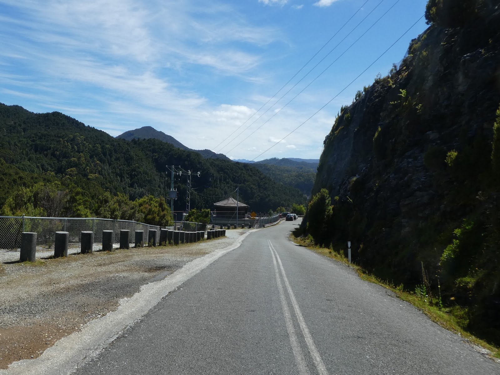
we began the relatively short journey from Strathgordon to the dam, along the road still maintained by the Hydro Commission staff, which took us past the blasted cliffs of white rock

and along the long, narrow, man-made gorges

until we reached the final run into the dam carpark. The guard rail you see here is not there for show. The Gordon River gorge below the dam is frighteningly steep and deep.

With the Cruiser safely stowed we trudged on down the last few metres to the small hut type building below,

the Gordon dam lookout, perched precariously below a cluttered mass of dam infrastructure (and there was our first glimpse of the wall!).

We toddled on past the sheer blasted cliffs which line the other side of this very last stretch of road,

and joined our fellow gawkers in the small observation hut.

This shot I took a little later does provide some idea of how this all works here, but even this does not really show just how deep the narrow river gorge below the dam actually is.

And, at last, this is what we had come to see, the famous curve of the Gordon River dam wall,

with the captured waters of this small section of Lake Gordon stretching serenely beyond the massive structure which was preventing their unimpeded flow

into the ravine down which the Gordon River once thundered.

Out of consideration for my aged and aching knees we decided against tackling the steep stairway which would have enabled us to access the walkway across the top of the dam. But I did wander down past the lookout (as you saw previously) and from this vantage point was able to capture some of the outward curve of the back side of the dam's wall (again prior knowledge was a help!)

This shot, courtesy of the Pedder Wilderness Lodge we had just left, taken obviously when the water level was much lower, does give a better idea of just how far this wall does bulge.

And, finally, before we move on, this rather blurred photo I found on the Hydro website, shows what we could never achieve, a view from the foot of the wall to the top.

The first excavation got under way here at the dam site in January 1970, but it was not until two years later that the concrete pours began. In that time a staggering 144,500 cubic metres of rock and soil was removed.

In the period between January 1972 and the final pour in November 1974, 157,500 cubic metres of concrete had been used to complete this curved dam wall, which now stood 140 metres high and 192 metres wide at the crest. Its width at the base is 18 metres decreasing to a mere 2.7 metres across the top of the wall.

Apart from its location, this dam is unusual in another significant way. I suspect most of us are used to the fact that many dam walls are curved, but the Gordon River dam is not only curved from one side of the gorge to the other, it bulges in an outward curve from the top to the bottom (which can just been seen in this construction photo....if you know what you are looking for!)
So the immediate question is, just what did result from all this effort? Quite a bit really. Lake Pedder and its companion Lake Gordon, together comprise the largest inland freshwater storage in Australia, covering more than 500 square kilometres and holding more than 37 times the volume of the water of Sydney Harbour. The folk around Lake Argyle and the Ord River still quibble, but there is no dispute....they run second!
And of course, in conjunction with the dam there was a power station to be built, but I'll have a bit more to say about this shortly.
For us, now much better informed about what we were about to see than we had been on arrival, it was time for a last quick look around Strathgordon before we headed out on the final stretch of this 'road to nowhere' (which is actually quite untrue....it goes somewhere quite significant).

Leaving the rear car park of the lodge, we first drove past the local automatic weather station, something I would not have normally included in a missive such as this, but my attention was drawn to a small plaque on the fence.

Here was the final word about Strathgordon's weather, a pithy comment on the trials and tribulations faced by those who lived in the construction village and those who remain here today.

And yes, apart from the staff of the Pedder Wilderness Lodge, Strathgordon remains home to a small population of mainly hydro workers responsible for maintaining the systems infrastructure and so on.

We initially suspected that quite a number of the remaining cottages we spied in other parts of the town were unoccupied, but the tell-tale satellite dishes on the roof of each was a dead give-away.

And the folk remaining here at Strathgordon can enjoy the indoor swimming pool and other recreational amenities,

such as the town basketball/tennis courts we spotted not too far from where we had parked.
With a great bar and restaurant on the doorstep, and some of the finest trout fishing to be had on the island equally close, I could think of worse places to live than at Strathgordon....if wet weather did not present a personal problem that is!


With one last glance at another of the long, almost mini-fiord type reaches of Lake Pedder
we began the relatively short journey from Strathgordon to the dam, along the road still maintained by the Hydro Commission staff, which took us past the blasted cliffs of white rock

and along the long, narrow, man-made gorges

until we reached the final run into the dam carpark. The guard rail you see here is not there for show. The Gordon River gorge below the dam is frighteningly steep and deep.
With the Cruiser safely stowed we trudged on down the last few metres to the small hut type building below,

the Gordon dam lookout, perched precariously below a cluttered mass of dam infrastructure (and there was our first glimpse of the wall!).

We toddled on past the sheer blasted cliffs which line the other side of this very last stretch of road,

and joined our fellow gawkers in the small observation hut.

This shot I took a little later does provide some idea of how this all works here, but even this does not really show just how deep the narrow river gorge below the dam actually is.

And, at last, this is what we had come to see, the famous curve of the Gordon River dam wall,

with the captured waters of this small section of Lake Gordon stretching serenely beyond the massive structure which was preventing their unimpeded flow

into the ravine down which the Gordon River once thundered.

Out of consideration for my aged and aching knees we decided against tackling the steep stairway which would have enabled us to access the walkway across the top of the dam. But I did wander down past the lookout (as you saw previously) and from this vantage point was able to capture some of the outward curve of the back side of the dam's wall (again prior knowledge was a help!)

This shot, courtesy of the Pedder Wilderness Lodge we had just left, taken obviously when the water level was much lower, does give a better idea of just how far this wall does bulge.

And, finally, before we move on, this rather blurred photo I found on the Hydro website, shows what we could never achieve, a view from the foot of the wall to the top.
Believe it or not, there is an adventure company here in Tasmania which offers the chance to abseil off the top of the dam wall to the rocky floor below.

For those with $210 to spare and nerves of steel, this could be you! I had to chuckle when I saw the credit for this shot I found on the company website.....'breakloose' did not strike me as inspirational advertising for this activity!!

This is promoted as the highest commercial abseil offered in the world (something I would not challenge), so if you too want to look as insignificant as this, the Gordon dam awaits you (a death wish is not mandatory, but it would help!)

Of course this leads to the obvious question. Once down, how to you get back up? 'Tripadvisor' provided the answer.........see the ladder?
When a much younger man I did abseil as part of my Commissioned Officer training, but believe me, the cliffs of the Adelaide Hills near Echunga were a far cry from the drop here at the Gordon dam. Not on your Nellie, thank you.
With hearts racing at the very thought, we completed the much more sedate climb back up to the waiting Cruiser and began the return trip to New Norfolk.
We had but one last mission in this rugged neck of the Tassie wilderness.....to find the power station.

Obviously we had to drive back the way we had come in and in doing so we came across a vantage point not far from the dam which offered another view out across a section of Lake Gordon.

Not far beyond this point a roadside sign pointed to a boat ramp. That should be worth a look. So down we went to the water's edge which in itself proved to be unremarkable until we looked around behind us.

There it was, a tower poking out above the surface. We knew we must be close, but from here this was all we could see.

Back to the main road and on a touch further and we came to another vantage point, and from here we had a much better view of all that is to be seen above ground.

Here is another shot of all that can be seen from the road of the largest conventional hydro power station in Tasmania, and there is a simple reason for this......

....it is all underground, as this information plaque we found at our new vantage point explained.
Another diagram showed us how this all fitted together.

What an incredible feat of inventive engineering this is and it was all happening beneath our feet.

For the statistically minded, here are the relevant figures.

First commissioned in 1978, the three huge turbines spinning away beneath us provide just under 15% of the total power needs of Tasmania. This shot from 'hydro100' shows part of interior. The three blue structures are just the tops of the massive turbines.
So there you have it. Not much to see from the road, but there was plenty going on below.

Now that we really did know how these pieces fitted together we pushed on to find yet another little side track which we thought was worth exploring.
It took us to a small parking area high above the water from where we took in our last look at Lake Gordon. It was here that the obviously low water level confirmed what we already knew. Tasmania was in the grip of an unusually dry summer from which not even the largest fresh water storage system in the country was immune


Obviously all this generated power has to be transmitted to where it is needed, and initially the transmission lines were strung between a type of tower we had never before seen.

For some reason, a little further down the road, these more conventional looking towers came into view. Why the difference? Absolutely no idea!

As I mentioned earlier, we popped back to Ted's Beach for lunch before heading back to New Norfolk. Not far into the return journey I found a vantage point from which the last piece of the south-western wilderness power infrastructure puzzle fell into place. This was a section of the McPartlan Pass canal, the waterway which links Lakes Pedder and Gordon.

That was it. We were done. It was high time to be getting back. But just before we left the lakes area the roadside threw up another surprise, this time in the form of a heap of hives. As we spent more time in the west of the island, this sight became far more common as honey producers moved their buzzing little factories around from spot to spot in the scrubs and forests, sometimes along quite improbable tracks, in search of particular bush blossoms.

With still over 100 kms to go to our digs, we said farewell to the granite humps and crags of the Sentinal Range

and hightailed it back to, and through, Maydena.

By now we had left the western wilderness far behind us. We were back into timber country

and tiny timber towns like Fitzgerald, one which really did pass the 'blink and you will miss it' test!

The quaint little pub near the entrance to the Mount Field National Park tempted us briefly as we passed by, but we did not tarry,

and by mid afternoon we had well and truly exchanged the rugged ranges of the west for the gentle slopes of the Derwent Valley

and the last we were to see of the hop fields of Bushy Park. We had come full circle.This had been a big day. Over 250 kms of sometimes 'interesting' roads and another Tassie touring big ticket item ticked off.
We were ready for the next phase of our Apple Isle adventure. The west coast was beckoning. The moonscape around Queenstown, the harbour at Strahan, and the mining history of Zeehan were all in our sights, but to get there we had another couple of pub stays planned, one of which was to be far more pleasant than the other. Oh, yes, and this leg was to include the quite incredible 'Wall in the Wilderness' and one of the most miserable days we had spent here since arrival....weather wise that is. Don't touch that dial!
No comments:
Post a Comment