"Whatever you do, or don't do in Tasmania, a visit to Corinna and the Pieman River is a must." So spoke an old mate of your scribe's. He waxed lyrical about a cruise on the river in the good ship "Arcadia", the only Huon pine river boat known to be still in survey anywhere in the world!
I was enthused, Liz not so. Given that we had only recently done the Gordon River cruise, a float down the Pieman was not high on our agenda, but I was keen to see Corinna itself, the old temperate rain forest of the Tarkine, and the Pieman river crossing. I knew too, that the trip would take me through Savage River, and I was also keen to see that.

And, for those who night need the reminder, a visit to Corinna would complete the set of west coast mining towns, old and new. As I soon discovered, Corinna is anything but new!
So just where was I planning to venture today? The 120 km round trip from Waratah (red arrow) to Corinna would take me almost to the west coast again, but not quite. As you can see from this

Google Earth offering, this tiny township lies on the Pieman River some 18 kms upstream from it mouth. The blue arrow indicates the Savage River mining area, and as I later discovered, the large blotch appearing here on the otherwise green wooded landscape is indeed an ugly reality.
This piece, from the Corinna Wilderness Lodge Website, gave me a good insight into what I was about to see:
"Corinna, which was once called Royenrine, was the
aboriginal name for a young Tasmanian tiger. Corinna is the only
surviving remote area historical mining settlement in Tasmania.
Corinna’s rip roaring days were in the goldrush of the late 1800’s, when
it had two hotels – one on each side of the river. Corinna was born
when prospectors pushed overland south from Waratah to the Heemskirk,
Zeehan and Lyell regions. They cut a track from the river at a point
some 19km from its mouth and at this exact crossing point Corinna was
established when gold was found in the Pieman’s tributaries.
The Corinna goldrush was at its peak from the mid 1870’s to the early
1880’s and the largest nugget of gold ever discovered in Tasmania
(7.5kg) came from Rocky River, a small tributary of the Whyte River,
(itself a tributary of the Pieman) a few km upstream from Corinna in
1883. It aroused considerable excitement and attracted many men from other Tasmanian goldfields.
By 1893 the town had more than 30 structures including the two
hotels, a post office, a number of stores and shops, slaughter yards and
numerous residences.
These were colourful days for Corinna, with a population of 2500
people and sailing ships and steamers making the hazardous entrance
through the Heads to bring in eager prospectors and suppliers.
It was far from the quiet, peaceful place it is today.
Prospector-historian Mark Ireland, who knocked around the West Coast in
the boom days, said it was the toughest town he had ever been in – and
there were some rough and tough towns in the west in those years.
Eventually, the town declined in population when the Emu Bay railway to Zeehan was opened in 1900."
So there you have it. Although Corinna appears on the posters as the west coast 'gold' town, that is a thing of the distant past.
So there you have it. Although Corinna appears on the posters as the west coast 'gold' town, that is a thing of the distant past.
I set out on the 120 km return trip without my road trip photographer, the upshot of which is that there are very few of the highway itself, other than some I snapped on the way back. Although the road was sealed to Savage River, it took me through some pretty mountainous country. I was loath to be waving a camera about with only one hand on the wheel (as you will see later).
Apart from all else which goes on here today, Corinna is the location of the only crossing over the Pieman River on the gravel road which connects Arthur River (to the north) to Zeehan, a road which traverses the dense rain forest through the area known as the Tarkine.

Apart from all else which goes on here today, Corinna is the location of the only crossing over the Pieman River on the gravel road which connects Arthur River (to the north) to Zeehan, a road which traverses the dense rain forest through the area known as the Tarkine.

I couldn't find a decent chart of this road to lift from the Internet, so have resorted to another of my 'arrow' efforts overlayed on a Google Earth shot. The red line is a very approximate route line of what is known as the 'Western Explorer Highway' with the yellow arrow indicating the Pieman River crossing at Corinna.

Because it is the river crossing point, Corinna is sometimes described as one large car park. This is a bit rough, but there is no doubt that the car park here is substantial. At the time of my arrival quite early in the morning, it was all but empty.

But not entirely. This group of bikers had gathered to await the arrival of the ferry from the other side of the river (very noisily I might add....they were like a mob of school kids...all trying to outdo each other with displays of their (questionable) local knowledge!)

Well, I thought, this is as good a spot as any to begin my Corinna ramble. Any from South Australia would call this 'ferry' a punt, but I'll not be too parochial about it.

There are two comments I would make, however. The first is that it is anything but commodious, and the second.....what a licence to print money this little venture is. The joys of a monopoly!

This obvious 'gouge' is tempered a tad by a local sense of humour,

but which ever way you look at it, this operation remains a good little earner. As the intrepid two wheeled adventurers were ferried across the calm waters of the Pieman, I calculated that the ferryman had just pocketed at least $150, and it was just 0900 hours.

As the 'Fatman', as this punt is known, neared the other bank, I decided to visit the other famous Corinna craft, the beautiful looking 'Arcadia II' which was lying alongside its boarding pontoon nearby.
This vessel cruised the Macquarie Harbour from 1961 until it was brought here to the Pieman by the Poulson family (who also reinstated and operate the punt) in 1970. Normally daily cruises to the Pieman River mouth and back are on offer. I am more than glad that this was not on my agenda for the day.....I soon established that the good ship 'Arcadia' was undergoing maintenance so I was not even to be given the opportunity of watching her under way on the river, which was something of a disappointment.
But at least I had seen what is reputed to be the only boat of its kind in the world!

It was still a touch early for any real activity around this tiny town, so I decided to toddle off on one of the two walks immediately available from either end of the car park, a riparian ramble upstream which began with a jaunt through the local camp ground.

This is advertised as 'bush camping' an apt description, and I would have to say, quite appropriate for this area. There is far more up-market accommodation available, as I found later, but for those who are prepared to haul their vans or other forms of mobile home to Corinna, they will indeed find themselves communing closely with nature.
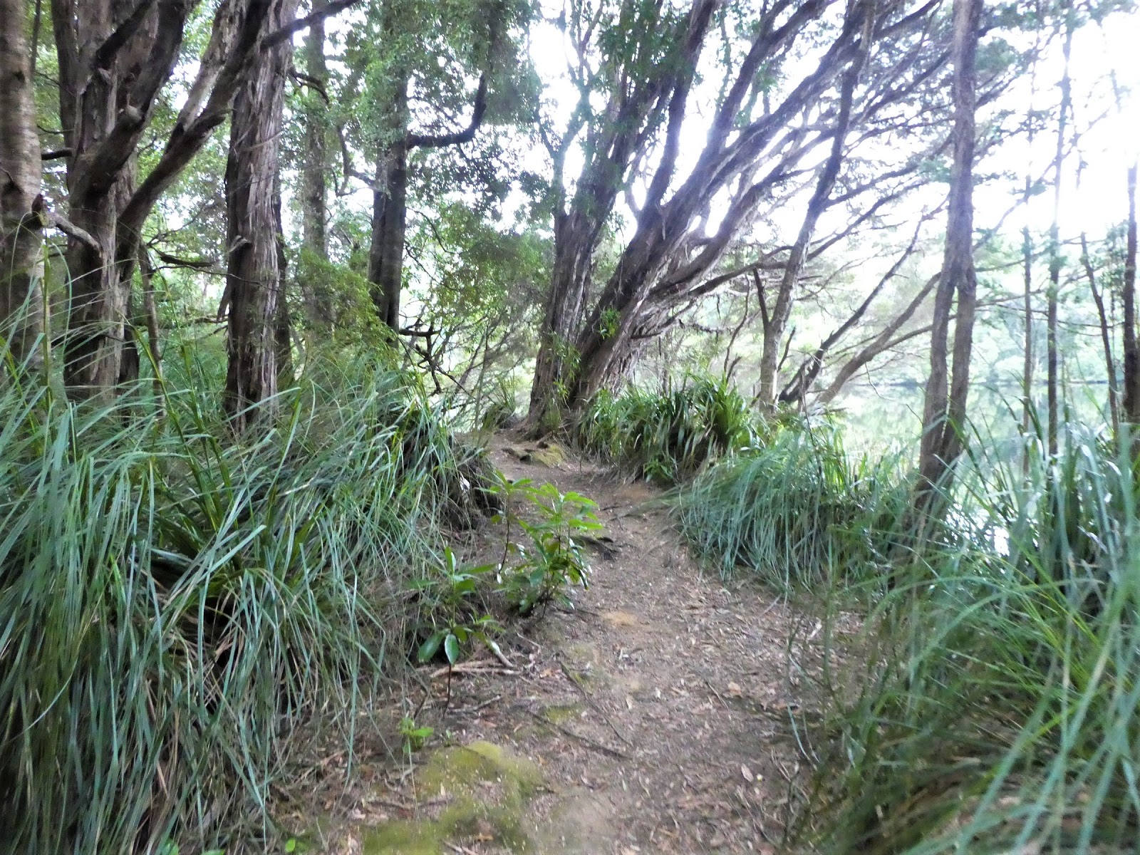
As will become evident, the walk on which I was now embarking is the the more challenging of the two immediately available through the rain forest along the northern bank of the Pieman (the other begins with a boardwalk).

The sky was somewhat overcast and there was a decided nip in the air, but that did not seem altogether inappropriate for a stroll through what has been described as some of the densest temperate rain forest anywhere in Australia. This track was certainly not one for the handicapped,

but it was not long before I was afforded one of several grand views along this most impressive waterway.

The surface of this track varied constantly

as did the passing scenery as it wound past large and leafy fronds of ferns.

Regular planked gully crossings took me through jumbles of fallen trunks

and past open areas where much larger trees had come to grief in the past.

After about fifteen minutes into this jaunt the track deteriorated quickly. Gone were the flat areas and it was 'eyes down' to scramble over tree roots, large

and small all just lying in wait to bring down the unwary. By now I had decided that it was almost time to go about. I had more to do with my time than pick my way along this increasingly difficult path where the need to remain upright meant that it was virtually impossible to take in my surroundings.

But I was still on the lookout for river views, and was soon to be rewarded. Even on this gloomy morning, the Pieman presented magnificently, an postcard picture of mirror calm serenity.

I had now been scrambling along this bush track for nearly half an hour. It was definitely time to head back. As is oft the case, the return walk brought new vistas, including this looking downstream towards the river crossing point. This really was the western wilderness at its best.

After meandering back through the camping ground, I decided that I was on a roll.

I would take a quick look at the other local walk before 'doing the town'. This took me across the car park area and initially past the local boat ramp, which was about to put to good use.

Lucky buggers! With scenery like this all around, a fishing trip here would definitely fall within the ambit of that old saying....'a fish would only be a bonus'!
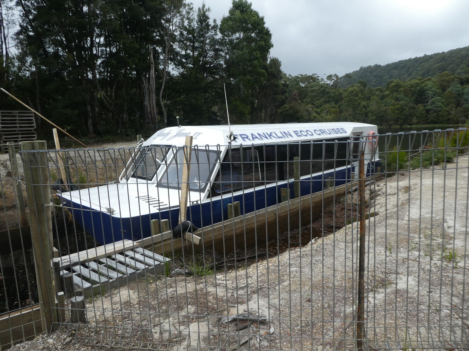
Before reaching the 'formal' walkway through the forest, I was surprised to find this vessel in a small slipway. I had believed that the 'Lady Jane II' normally operated on the Huon River. She was a long way from home and I still have no idea why.

This area of the Tarkine rainforest is the most northern part of Tasmania in which the Huon pine grows. The National Parks mob have definitely taken advantage of that.

Ah, after my last forest jaunt, this was to be much easier going.

As we had found elsewhere on the island, this walkway was lined with signs which identified various species of trees

in the immediate area.

The walkway signs even included local grasses, such as this 'Cutting grass', named thus for a very good reason, as any foolish enough to unwarily grasp a frond will soon discover.

Needless to say, tree ferns were in abundance. They just thrive in this cool, shaded environment.

I'll not bore you to death with an endless series of 'tree signs', and I think we have had enough of flora for the moment, but this boardwalk did bring me to another set of information boards which provided a real insight into the other major industry of early Corinna (other than gold prospecting).

So I'll give my typing fingers a brief rest and

let them tell their own story, yet another of the harsh, unforgiving and dangerous life of the bush pioneers of Tasmania.

Beyond this point the boardwalk came to an abrupt end, as did my stroll through this part of the forest. Tree markers showed the way from here on. I had no desire to embark on another bush bash, and made my way back to 'town'.

Before I wander around Corinna, let me again 'set the scene', firstly with this incredible shot from 'Peter Bellingham aerial photography' which shows the Corinna township as a white scar on the river bank.
And although the River Pieman appears to be meandering away from the coast at this point, it does curve sharply just beyond the right of this photo to head south-west to the coast.

And here, thanks this time to 'tripadvisor', I can bring you another aerial view of this isolated township in the wilderness.

I began my personal tour at the pub, the Tarkine Hotel, which opened in September 2008.

where its elevated front verandah presented me with a grand view out across the car park and the ferry crossing point.

The hour was still much too early for there to be any action at the bar and understandably I did not tarry.

At the rear of the same building the Corinna general store provides a range of basics for the locals and those visitors who are self-catering.

Almost opposite the pub building on the other side of the road into town, the plaque in front of this modest little wooden cottage informed me that this was the site of one of Corinna's two earlier pubs which had been sensibly situated, one on either bank.
As was recorded in the introductory piece about early Corinna, this was as tough a town as existed in Tasmania during its early years, and the pubs were the centre of much mischief. I recommend a quick trawl on the Internet for some of the stories, particularly the tale of the burial and wake held for one of the early publicans. That was a day to remember!
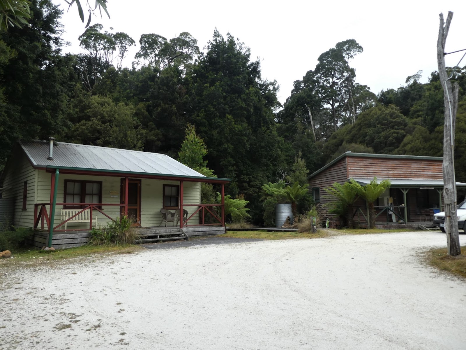
Most of the buildings which make up 'modern' Corinna are given over to tourist accommodation. Many are operated by the Corinna Wilderness Lodge.

A fair range of options are available, from luxury rooms in the lodge to self catering cabins.

Most are relatively new and have been built in a style to suit their location,

but a few originals still remain.

but a few originals still remain.

Of these, Pete's Place is one of the standouts.

This is what Pete called home when he was not out patrolling the roads. I just hope it had a very large fireplace!

There are few permanent residents in today's Corinna, where living off the grid demands the use of all the help they can get from nature.

I suspect that this 'holiday house' says as much about Corinna as anything else I found.

It was little more than a slab lean to with a large undercover area

the 'interior' of which I have to say looked far less than inviting.

But as I took a quick peek inside 'Spear Ling's Corinna Retreat', it soon became obvious that this shanty had been the venue of many a fine time and that Spear Ling, whomever he may be, or have been, was a grand host. At least that was demonstrably the view of the Schramms, Bastard and Lassie and Snipe and Big Ears. I could just imagine!

Spear had a fine plot atop the rise, and from here I wandered down the path,

past the back end of the general store

and back to the car park, where an erstwhile camper was preparing to cross the Pieman and take the track down to Zeehan.

There's another $30 for the ferryman. During my comings and goings, I had seen at least four transits including the initial motor cycle group. I estimated the takings to have been in the order of $250 so far this morning....as I said earlier, a nice little earner.
What a fascinating place this was. Apart from being the Pieman crossing point, it is the HQ for a variety of significant bush walks, for fishing and kayaking on the river, trips to the mouth and its beach, and is a haven for those who just want to chill out in what can genuinely claim to be a pristine environment with a significant history. I suspect that evenings in the Tarkine Hotel could be jolly affairs indeed.

Well, now for the trip 'home to Waratah' where the first 25 kms or so back to Savage River would be on the white silica surface common to unsealed rods in this part of the State.

This took me back through the edge of the Tarkine for some distance

before I climbed out of the river valley and into the stunted scrub vistas of the hills.

Here the road twisted

and turned through a pretty bleak landscape

until I reached the blacktop once more and the mining village of Savage River with its rows of pretty basic looking accommodation

and its inevitable dongas which are part and parcel of life in just about every mining town in Australia.
Interestingly, for a mine which is still operational in this area, it does not rate a mention on the 'Rich in Minerals, Rich in History' placard we saw in Queenstown. Could this be because the iron ore which is mined here is not considered as glamorous as gold, zinc, copper, tin or galena, or is it because this operation is a real 'johnny-come-lately' in the west coast mining history?
Although iron ore was discovered here last century, difficulties associated with its extraction and delivery to the coast meant that nothing was done to exploit it for many years.

This all changed in 1965. The town to house the mine workers was purpose built (it looked like it!) and open cut mining began. The real clincher for this to be viable was the fact that the ore can be dissolved into a slurry which is then piped, yep, that's right, piped the 85 kms to the north coast at Port Latta (thanks to 'The Habitat Advocate' for the map).
Here it is reconstituted into pellets and shipped off to......?? Right again, China, where the company which now owns the operation, Grange Resources h,as a contact to supply China's largest steel mill, Shagang, until 2030. The initial supply estimate of 45 million tonnes over a twenty year period has recently been upped to 107 million, a handy increase indeed, which is very good news for the 600 company employees and assorted other contractors.
This is a very significant mining operation and I pulled over on the other side of the township to try and get a feel for the place.
As I gazed out across the slurry lake to the overburden heaps far in the distance, I could now see why this mine appears as such a slash on the earth shots.

It is vast, and it is ugly (but then again where can one find a pretty mine) and in all fairness this is such a contrast to all around it that the comparison is inescapably magnified.

I could not see any of the open cut workings, but as I stood staring out over this wilderness, I spied some movement.

A bulldozer was hard at it, pushing the material into piles.....why...absolutely no idea. I can only assume that this has something to do with preparing the stuff for its piped journey to the coast.
So much for Savage River, named, it is believed after one Job Savage, a storeman at Corinna in the 1880's. But the name could well apply to the weather, which, like nearby Waratah is less than inviting for much of the year.
As I noted at the outset of this offering, I did poke the camera out of the window a couple of times to try and capture the challenges of the road back to Waratah through the mountains,


but common sense and survival instincts restricted this endeavour to only two attempts. Just let me say, it is a drive worth doing, preferably as the passenger!
And so it came to pass that I took my old mate's advice and visited Corinna, recognised as probably the most isolated township in Tasmania. I was glad to have done so.

And I had my Corinna passport stamped......the Cruiser was absolutely covered in fine, white silica dust, to the extent that this photo does no justice. Ah well, no pain no gain as they say.
I have to say I had a marvellous morning. Let me take our joint leave of Corinna and the Pieman River with one last question.....the origin of the river's name. Some say it was after a local pastrycook, Thomas Kent of Southampton who was transported to Van Diemen's land in 1816 and was nicknamed 'The Pieman'.
Others more plausibly argue that it is named after Alexander Pearce, the convict we first learnt of during our Sarah Island visit, a truly evil man who became know as 'The Pieman' because of his penchant to kill and eat his fellow escapees.......more than once, but only when he was starving!
I'll leave you to look up his story at your leisure, if you dare!
No comments:
Post a Comment