Surely there would be hardly a soul in Australian (and beyond) who has not heard of Tasmania's Cradle Mountain, and surely any trip to the Apple Isle must include a visit to that National Park and a stroll around Dove Lake.
This venture certainly featured high on our priority list but the question remained.....could we take the van there or should we base elsewhere? This question was quickly answered.
The Cradle Mountain caravan park, which is rustic to say the least (but that tends to be what folk want in these areas) has limited facilities and water, and, although the sites are secluded, they are dirt based and, wait for it.....$59 per night! Not that any of that mattered to us. Being in a National Park, this is not a pet friendly camp. Scratch the van at Cradle Mountain.
As we now knew, Tassie is not big, and there were several base town options on our tourist plate. We chose Waratah, for several reasons. It was sufficiently close for a comfortable day trip, offered what appeared to be a very good Council camp ground, and, as we discovered, is a town with a fascinating and quite significant history. Oh, yes, and it features a waterfall in the main street....that in itself was enough to get me in!

Our trip of 120 kms today would take us up the A10, through Rosebery and Tullah, and whilst in Waratah, I planned to visit Corinna and the Pieman River.
And, as a quick glance back at this Queenstown poster shows, Waratah was the home of tin

Our trip of 120 kms today would take us up the A10, through Rosebery and Tullah, and whilst in Waratah, I planned to visit Corinna and the Pieman River.

mining in the island's north-west, so that would see out the mining areas this entire region of Tasmania.

Although we had had a marvellous stay in Queenstown, with a morning mist drifting across the hilltops and a chill in the air, we were not unhappy to be leaving.

Nothing much changed around us initially as we climbed north-west out of Queenstown for the last time, passed the Strahan turn-off and headed off towards Zeehan.

Some fifteen minutes later, however, the skies cleared slightly as we crossed the bridge over the Yolande River. I had spotted what looked like a very promising camping area (the bare ground at the right of this photo) when we came through here on our day trip to Zeehan.

Today it was time for a closer look.

A quick gallop back down along a track beside the river bank led me to a flat, open free camp site, surrounded by screening bush.

Here impossibly clear waters flowed over the rocky river bed,

and this river-side fireplace confirmed that I had been right. Note to self for a return visit....'a few nights alongside the Yolande River'!

Now feeling quite pleased with myself, we pushed on, past the Zeehan junction

and along the A10 towards Rosebery.

A few odd sprinkles continued to dot the windscreen as we made our way through the type of country we had anticipated......

.........hilly and densely timbered, but we had the highway virtually to ourselves, and driving challenges were few.

The overhead bucket conveyor system which crossed the highway

and the roadside mullock heap

 on the approaches into Rosebery left us in no doubt that we were still travelling through mining country, in this case zinc.
At once stage we had briefly considered Rosebery as our Cradle Mountain touring base, but as we

drove along the main street and through the town, we remained quite happy that we had discarded that idea.

 Yet another junction came and went. The route up from Queenie along the B28, past Lake Plimsoll, had also come under some planning consideration, but we had wanted to check out Rosebery and so took the A10. The fact that the B28 was a secondary route, and, from what I could see on Google Earth, traversed some pretty rugged countryside, also featured in this decision.
By now, over an hour into our trip for the day, the mists had cleared even further, exposing the impressively rugged, craggy ridges and peaks of the mountains of the west.

The small town of Tullah lies just off the highway

as a result of which we saw very little of it as we drove through, but it remains firmly embedded on our 'to do list' for our inevitable return visit to Tasmania. Let me show you why.

Mining for galena has long since ceased here, and Tullah, which, lies on the bank of Lake Rosebery (thanks to 'Australia Guide' for the photo), is now a serene and peaceful holiday town in what must be one of the most beautiful locations on the island. We shall return!

But for today our destination lay further afield, and we pushed on,

over the Mackintosh Bridge at the top end of Lake Rosebery


Fortunately the stretch under repair was short, and in no time flat we were scooting happily along the good blacktop past the Cradle Mountain turn-off

until we reached our final junction for the day. Waratah was in our sights.

As we made our way into the town,

with its very colourful welcome sign, we were glad we had done our homework.


Here the town colour continued, in front of the modest office building

and in simple kerbside pots.
Our welcome from the office staff was warm. With our fee of $28 per day handed over, we were invited to wander down to the park grounds, which were just behind the office building, and chose any site we liked.

So, after a quick 'U' turn, we made our way back to the junction we had just passed, turned right past the old mine manager's house,

and toddled the short distance to the entrance road

which ran alongside part of the quite extensive lake complex here in Waratah.

We had already done the right thing and pushed on regardless.

Powered sites here were available in this lower, gravel based area, which had the advantage of being quite flat,

but we were far keener to find some grass and so headed up the slope to this upper section of the camp ground. Fortunately we were able to snare the last of the powered sites at the bottom end of this row of vans. This had two benefits.....one there was no room for any one to squeeze in alongside the Cruiser (elbow room!)

and secondly, this was one of the most level parts of this section of the park.

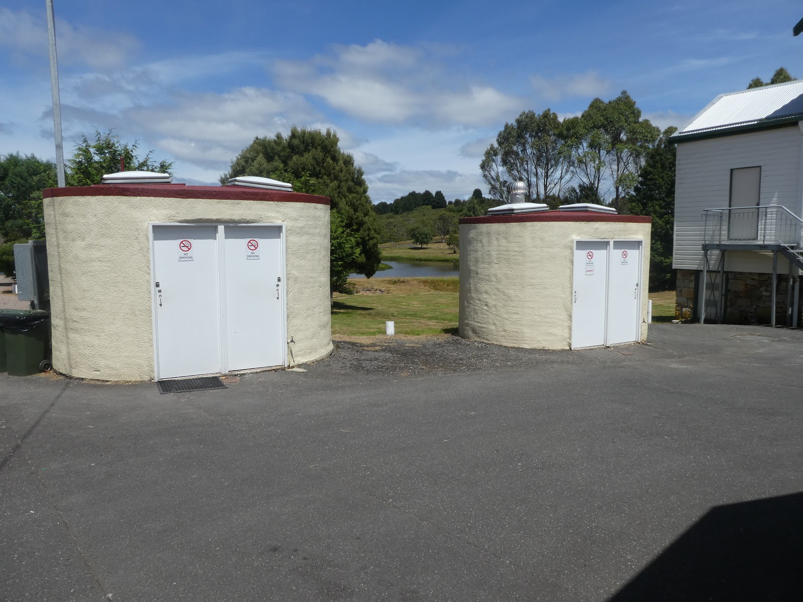
Informally managed parks such as this can be a bit of a punt in terms of layout and infrastructure, but we could not have been happier with what we found. Power and water were easily attached, and the rather quaintly housed ablutions located at the top end of the park were self-contained, virtually brand new and kept spotlessly clean.

For those either inclined or in need, these two outdoor shelters

provided more than adequate cooking, washing up and eating facilities. We were more than happy with our decision to make this our base for a few days.

And for us, this park even came complete with ready-made happy hour companions.
We had no sooner settled in than our erstwhile companions, from our overnight stay at the Gretna pub a week or so ago, pulled in next door. The party rolled on!

.........hilly and densely timbered, but we had the highway virtually to ourselves, and driving challenges were few.

The overhead bucket conveyor system which crossed the highway

and the roadside mullock heap

 on the approaches into Rosebery left us in no doubt that we were still travelling through mining country, in this case zinc.
At once stage we had briefly considered Rosebery as our Cradle Mountain touring base, but as we

drove along the main street and through the town, we remained quite happy that we had discarded that idea.

 Yet another junction came and went. The route up from Queenie along the B28, past Lake Plimsoll, had also come under some planning consideration, but we had wanted to check out Rosebery and so took the A10. The fact that the B28 was a secondary route, and, from what I could see on Google Earth, traversed some pretty rugged countryside, also featured in this decision.
By now, over an hour into our trip for the day, the mists had cleared even further, exposing the impressively rugged, craggy ridges and peaks of the mountains of the west.

The small town of Tullah lies just off the highway

as a result of which we saw very little of it as we drove through, but it remains firmly embedded on our 'to do list' for our inevitable return visit to Tasmania. Let me show you why.

Mining for galena has long since ceased here, and Tullah, which, lies on the bank of Lake Rosebery (thanks to 'Australia Guide' for the photo), is now a serene and peaceful holiday town in what must be one of the most beautiful locations on the island. We shall return!

But for today our destination lay further afield, and we pushed on,

over the Mackintosh Bridge at the top end of Lake Rosebery

and on across a 'formal' boundary. According to this sign, we had now officially entered 'The North-West',

where our highway welcome was not quite what we would have wished for.....roadworks. Whilst many Tassie roads have their challenges, this was not usually one of them.

Fortunately the stretch under repair was short, and in no time flat we were scooting happily along the good blacktop past the Cradle Mountain turn-off

until we reached our final junction for the day. Waratah was in our sights.

As we made our way into the town,

with its very colourful welcome sign, we were glad we had done our homework.

We knew that rather than turn off immediately to the camping area, we had firstly to drive a little further along the main road into the town and present ourselves at the Council offices to book in.

Here the town colour continued, in front of the modest office building

and in simple kerbside pots.
Our welcome from the office staff was warm. With our fee of $28 per day handed over, we were invited to wander down to the park grounds, which were just behind the office building, and chose any site we liked.

So, after a quick 'U' turn, we made our way back to the junction we had just passed, turned right past the old mine manager's house,

and toddled the short distance to the entrance road

which ran alongside part of the quite extensive lake complex here in Waratah.

We had already done the right thing and pushed on regardless.

Powered sites here were available in this lower, gravel based area, which had the advantage of being quite flat,

but we were far keener to find some grass and so headed up the slope to this upper section of the camp ground. Fortunately we were able to snare the last of the powered sites at the bottom end of this row of vans. This had two benefits.....one there was no room for any one to squeeze in alongside the Cruiser (elbow room!)

and secondly, this was one of the most level parts of this section of the park.
Informally managed parks such as this can be a bit of a punt in terms of layout and infrastructure, but we could not have been happier with what we found. Power and water were easily attached, and the rather quaintly housed ablutions located at the top end of the park were self-contained, virtually brand new and kept spotlessly clean.

For those either inclined or in need, these two outdoor shelters

provided more than adequate cooking, washing up and eating facilities. We were more than happy with our decision to make this our base for a few days.

And for us, this park even came complete with ready-made happy hour companions.
We had no sooner settled in than our erstwhile companions, from our overnight stay at the Gretna pub a week or so ago, pulled in next door. The party rolled on!
No comments:
Post a Comment